Download
1 / 34
340 likes | 647 Vues
c. c. Wind is caused by: a. expanding and cooling of water vapor b. variations in temperature c. variations in air pressure d. heavy precipitation. b. Hurricanes form most frequently: a. Over land masses in middle latitudes b. Over warm tropical oceans

E N D
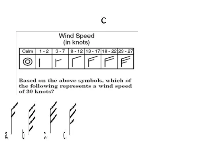
c • Wind is caused by: a. expanding and cooling of water vapor b. variations in temperature c. variations in air pressure d. heavy precipitation
b • Hurricanes form most frequently: a. Over land masses in middle latitudes b. Over warm tropical oceans c. Over tropical land masses d. At the equator
a • What is a front? a. a transition zone between two air masses of different density b. an area of precipitation c. a section of unstable air d. the center of a storm
b Air masses that originate in the Gulf of Mexico are a. Continental Tropical (cT) b. Maritime Tropical (mT) c. Continental Polar (cP) d. Maritime Polar (mP)
a Which diagram correctly shows wind motion between pressure areas? a. b. c. d.
c Base your answer to this question on the water cycle diagram shown below. Some arrows are numbered 1 through 4 and represent various processes. The clouds have formed primarily because moist air
d Compared to the climate conditions of dry inland locations, the climate conditions of locations influenced by a nearby ocean generally result in
c Thunderstorms which produce tornadoes: a. have very little cloud-to-ground lightning b. have updraft velocities that exceed 100 miles per hour c. have rotating updrafts c. will not produce hail
b Which location most likely recorded the highest wind speed? A B C D
c • Which of the following weather elements always decreases as we climb upward in the atmosphere? a.wind b.temperature c.pressure d.moisture
a Which factor most likely causes two cities at the same elevation and latitude to have different yearly average temperature ranges?
a Which map view best represents the pattern of isobar values, in millibars, and the pattern of wind flow, shown by arrows, at Earth’s surface surrounding a Northern Hemisphere low-pressure center? a. B. c. D.
a Compared to a maritime tropical air mass, a maritime polar air mass has a
a Compared to an inland location, a location on an ocean shore at the same elevation and latitude is likely to have
d An air mass classified as mP usually forms over which type of Earth surface?
d Most water vapor enters Earth’s atmosphere by the processes of
c Surface winds within this low-pressure system generally flow
d • Which combination of climate factors generally results in the coldest temperatures? a. low elevation and low latitude b. low elevation and high latitude c. high elevation and low latitude d. high elevation and high latitude
b At which location is it most likely raining? • A • B • C • D
D What is the windless, rainy zone near the equator called? • Coriolis effect B) land breezes C) sea breezes D) doldrums
a Land breezes and sea breezes are created by the differences in— a. the heat capacity between water and land b. solar radiation reaching the Earth's surface c. the living organisms occurring in the land and sea d. the Earth's tilt on its axis
A Conduction is the transfer of heat through __________. A) touch B) empty space C) thoughts D) radiation
b What happens to barometric pressure as a storm passes through an area? • Rises • Falls • Stays the same • changes
c • Present-day weather predictions are based primarily upon A) cloud height B) ocean currents C) airmass movements D) land and sea breezes
c Why do clouds usually form at the leading edge of a cold airmass? A) Cold air contains more water vapor than warm air does. B) Cold air contains more dust than warm air does. C) Cold air flows under warm air, causing the warm air to rise and cool. D) Cold air flows over warm air, causing the warm air to descend and cool.
b Which event will most likely occur in rising air? • A) clearing skies • B) cloud formation • C) increasing temperature • D) decreasing relative humidity
a The 90 in the station model represents • Temperature • Barometric pressure • Dew point • Wind speed
d Which is not a high altitude cloud? • Cirrocumulus • Cirrus • Cirrostratus • stratus
c A map view of surface air movement in a low-pressure system is shown below.The air near the center of this low-pressure system usually will a. evaporate into a liquid b. reverse direction c. rise and form clouds d. squeeze together to form a high-pressure system
d At which location will the least amount of rain fall? a. A b. B c. C d. D
a The shift in global winds (to the right in the Northern Hemisphere) as a result of the Earth's rotation is called the • Coriolis effect • Jet stream • Westerlies • easterlies
a • What is the movement of air around the center of a HIGH air pressure system? A. downward, outward and clockwiseB. downward, inward and counterclockwiseC. upward, outward and clockwiseD. upward, inward and counterclockwise
b • Winds are named according to A. the direction they are blowing towardB. the direction they are blowing fromC. their speedD. their origin