Download
1 / 20
200 likes | 314 Vues
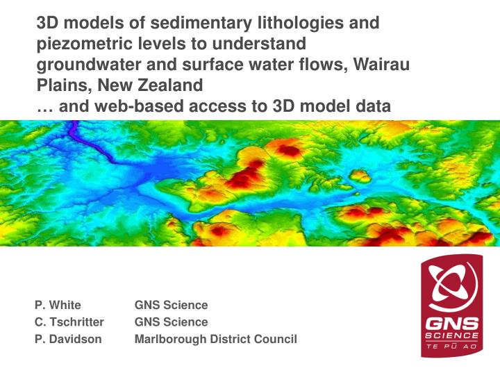
3D models of sedimentary lithologies and piezometric levels to understand groundwater and surface water flows, Wairau Plains, New Zealand … and web-based access to 3D model data. P. White GNS Science C. Tschritter GNS Science P. Davidson Marlborough District Council. Acknowledgements.

E N D
3D models of sedimentary lithologies and piezometric levels to understand groundwater and surface water flows, Wairau Plains, New Zealand … and web-based access to 3D model data P. White GNS Science C. Tschritter GNS Science P. Davidson Marlborough District Council
Acknowledgements Thanks to: • Harvey Thorleifson for the invitation to present this talk • GNS Science Groundwater Resources Research Programme for 3D model development (Wairau Plains) and GNS ‘seed’ funding (web site). • Groundwater managers for in-kind and direct support on model development, particularly Marlborough District Council and Bay of Plenty Regional Council (Janine Barber)
Outline of the talk Methods 3D models of geology and groundwater level: example of Wairau Plains Web-based access to model data • Web site demo Software used in talk: Earthvision and home-built including web and FORTRAN
Methods Building 3D geological models: two main types • Lithology (3D) • These models are used to understand the distribution of sediments relevant to aquifers systems and are particularly useful when interpreting drillers’ logs • Chrono – stratigraphic (typically 2D surfaces) • These models aim to understand strata in relation to time
Lithological models: a statistical approach with geological logs • Useful because we are uncertain about the quality of well logs • We use ‘pseudo-logs’ • e.g. blue = water bearing • pink = other The 3D model itself has an important role in data-quality checking Well log and pseudo log Reference: White, P.A. and Reeves, R.R. 1999. Waimea Plains aquifer structure as determined by three-dimensional computer modelling. Journal of Hydrology (NZ) 38 (1) 49-75.
Lithological models: a statistical approach with geological logs 1) Well log data quality checks • 2) Pseudo-logs are plotted in 3D space • 3) …and then modelled as continuous distribution in 3D as 3D grid and 3D ‘faces’ file • 4) Models developed separately for: • gravel; • sand; • silt and clay.
3D models of static groundwater level in 3D 1) Quality checks of static groundwater level data (e.g. remove wells where level is influenced by pumping) 2) Assemble as 3D points 3) Model as continuous 3D distribution in a conformal grid Unconfined area Confined area Holocene Gravel aquifer Holocene/ Pleistocene Gravel aquifer Static groundwater level (colour) and elevation of the base of the screen.
Web site access to model data Aim: access to 3D model data for everybody, e.g.: • education (e.g., children) • drillers • groundwater managers • Scientists • general public Some criteria: • not dependent of proprietary software • intuitive • fast • access to models from the field (i.e., smart phones) • uncertainty
An example of 3D models: Wairau Plain One purpose of this work: how does groundwater recharge travel to spring-fed streams? • Important to water management in the area The following slides show the results of: • Development of 3D models (geology and piezometric level) • Comparison of 3D geology and 3D piezometric level • Groundwater budget
Wairau Plain geology and historic hydrology Yellow = alluvial in west marine/estuarine in east
Study area: 1165 geological logs1562 static water level measurements
Results: 3D geological model: combines chrono- and lithology modelsMain purpose is to assess the distribution of Holocene gravels, sands and silts/clay
Results: 3D piezometric model and 2D water table Piezo contours in 3D Piezo contours in 2D
Results: 3D geological model, piezometric model and groundwater budget Approx 90% of nett gw inflow (Transition zone and west) flows to spring-fed streams West – east sections Figure 8.
Web-based access to model data Aims to provide model information to anyone http://data.gns.cri.nz/ebof/
Web access to model data: Aims to provide model information to anyone GNS Science has a programme of sub-regional 3D model development
Earth Beneath Our Feet web site: Aim to represent: Layers Properties and uncertainty
Conclusions 3D models • Models of lithology, chrono-stratigraphic units, when combined with models of static groundwater levels are very useful in understanding coastal aquifer systems • These models shown that most groundwater recharge in the Transition zone and west (approx 90%) flows to springs • This has significant implications for management of the system Web-based access to model information • shown to be great fun • … and it’s useful for groundwater managers