Download
1 / 67
710 likes | 1.13k Vues
RIVER STUDIES. The Changes downstream in a river valley. The Hydrologic Cycle. Infiltration = Groundwater System. Runoff = Surface Water System. Satellite view of river drainage, Middle East. What is this features?. Upper valley characteristics. Upper valley characteristics.

E N D
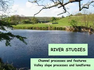
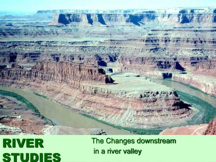
RIVER STUDIES The Changes downstream in a river valley
The Hydrologic Cycle • Infiltration = Groundwater System • Runoff = Surface Water System
Satellite view of river drainage, Middle East What is this features?
Upper valley characteristics “V”shape valley, vertical erosion dominant
Upper valley characteristics “V”shape valley, vertical erosion dominant Interlocking spurs
Upper valley characteristics “V”shape valley, vertical erosion dominant Interlocking spurs Slumping and landslides - very active hill slopes
Upper valley characteristics “V”shape valley, vertical erosion dominant Narrow, shallow channel, low velocity and discharge Interlocking spurs Slumping and landslides - very active hill slopes
Upper valley characteristics “V”shape valley, vertical erosion dominant Narrow, shallow channel, low velocity and discharge Interlocking spurs Slumping and landslides - very active hill slopes Large bed load derived from upstream and from valley sides
Interlocking spurs, Robinson, Lake District A typical upper course valley with interlocking spurs, steep valley sides and active slope processes
River load in upper course Why are they rounded? Boulders are large and semi-rounded, due to attrition within the loadand abrasion with the stream bed and banks
Rapids in the Upper Tees Valley WHAT IS A RAPID?
High Force waterfall, R. Tees WHAT IS A WATERFALL?
High Force waterfall, R. Tees Waterfall creates gorge as it recedes upstream by eroding the base and neck What is this feature called? HOW IS A GORGE FORMED? Plunge pool
Waterfall formation Look at the diagram, How is a waterfall formed?
Close-up of potholes How are these formed?
Erosion Processes Corrosion - Attrition- Abrasion (Corrasion) - Hydraulic Action- is when the river is loaded with material in suspension and scours away at the river banks. (Sandpaper effect) is the shear force of the river impacting on the sides of the river banks. is substances carried in solution such as acids. They dissolve rocks away over long periods of time. is when bed load collides into each other with the current flow and breaks down into smaller particles.
Middle course, R. Tees HOW DOES THIS DIFFER FROM THE UPPER SECTION?
Middle course, R. Tees WHAT DO YOU THINK THE ARROWS POINT TO? Valley opens out, more gentle slopes, wider valley bottom First signs of meanders River channel wider, deeper, greater velocity and discharge
Meandering Rivers WHAT IS A MEANDER?
Point Bar Deposits Point bar deposits grows laterally through time
Meander, R. Lavant, Chichester WHAT DO THE ARROWS POINT TO? WHICH WAY IS THIS MEANDER MOVING? Floodplain Slip-Off Slope River Cliff Point bar deposits on the inner meander bend where there is low energy
WHERE IS EROSION TAKING PLACE? Cut bank erosion (River Cliff) F A E B Point bar deposits } Meander loop C D WHERE IS DEPOSTION TAKING PLACE?
Meander on the R. Colorado WHY IS DEPOSITION OCCURING HERE?
Migrating meanders, R. Gongola, Nigeria WHY ARE THEY MIGRATING?
What happens to the river when it moves to the middles course • Gradient becomes less steep • River continues to erode vertically but LATERAL erosion now occurs in MEANDERS • What is MEANDER MIGRATION ? • Name three effects it have on the valley? • What factors effect how much load is being carried?
Transportation • What are the four methods of transportation? • Traction- is when large particles roll along the river bed • Saltation - is when smaller particles bounce and collide in a leapfrog manner across the river bed. • Suspension - is when the river holds even smaller particles and carries them in its current. This is when the river appears to be murky. • Solution - is when dissolved material is carried.
Lower Severn Valley Very wide floodplain Well developed meanders with bars in the channel indicating high sediment load Very gentle valley side gradients HOW DOES IT DIFFER FROM THE MIDDLE COURSE?
Flood Plains HOW DO YOU THINK THE TERRACES WERE FORMED? The entire floodplain can become covered with water during floods.
Ox Bow Lake Formation LOOK AT THE DIAGRAM & EXPLAIN THERE FORMATION
Levees WHAT DO YOU THING HUMANS MIGHT HAVE DONE TO THIS LEVEE?
Delta Formation WHAT IS A DELTA? DEPOSITON OF MATERIAL BY THE RIVER WHEN IT ENTERS THE SEA WHY DOES IT DROP ITS SEDIMENT
Mississippi Delta from Space MISSISSIPPI
The Nile Delta from space River Nile
Estuary Formation HOW DOES THIS DIFFER FROM A DELTA? The Lower Course of a river valley has been DROWNED by a rise in sea level or a fall in the land level. RAISED VALLEY SIDES USING YOUR ATLAS FIND AN ESTUARY (LOOK AT THE RIVER THAMES)