Download
1 / 8
80 likes | 205 Vues
2.6 Elevation & Climate. Understand the relationship between elevation & climate Chapter 4 p. 71. 2.6.1 Define Elevation p. 71. Elevation = height of a region above sea level Figure 1.6 p. 8 shows cross section of Canada. Winnipeg 239 m. 4000 m. Sea Level. DID YOU KNOW?.

E N D
2.6 Elevation & Climate • Understand the relationship between elevation & climate • Chapter 4 p. 71
2.6.1 Define Elevation p. 71 • Elevation = height of a region above sea level • Figure 1.6 p. 8 shows cross section of Canada Winnipeg 239 m 4000 m Sea Level
DID YOU KNOW? • Air temperature decreases 2oC for every 300m increase in elevation • IT’S TRUE!! In fact, the higher up we go; the colder it gets; hence snow on mountain tops
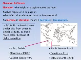
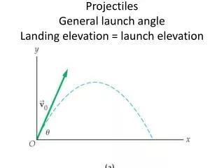
2.6.2 Describe the relationship between the elevation of a point and its temperature and precipitation. See Figure 4.19 – Textbook…what is the relationship between temperatures and elevation???? Stop La Paz & Rio de Janeiro have similar dist. from ocean & similar latitude. La Paz is much colder because of higher elevation . • La Paz, Bolivia • Elevation = 3600m • Coldest month = 9oC • Rio de Janeiro, Brazil • Elevation = 61m • Coldest month= 25oC
2.6.2 Describe the relationship between the elevation of a point and its temperature and precipitation. • Relief Rainfall • Windward Side of mountain • Leeward Side of Mountain • Rain shadow – What side?
Relief Rainfall – Recap!!! Elevation and Precipitation • Windward = side of a mountain wind blows toward • Leeward = side of mountain opposite from windward • Rain shadow = region on leeward side of mountain that receives little precipitation because most rain dropped on windward side.
Vancouver Prince George wind 2.6.3 Analyze the relationship between temperature and precipitation of a point and its location relative to a mountain system. • Cities higher up in a mountain have colder temperatures • Cities on leeward side have little rain • Cities on windward side have more rain • Match the city to the data • 1113mm rain & 0oC coldest month • 628mm rain & -12oC coldest month
2.6.3 Practice • #37 p. 71 • #40 a & b p. 72 • #41 a & b p. 72