Download
1 / 18
180 likes | 310 Vues
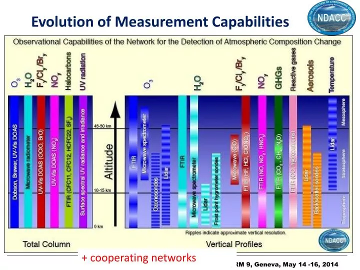
Evolution of Measurement Capabilities. + cooperating networks. Loss or Suspension of Data / Stations. O3 DIAL. T Lidar. Aerosol L idar. FTIR. MW O3. UV/VIS. Spec UV. Loss or Suspension of D ata / Stations: Summary. Diminished measurement capacity, in particular for O 3 Lidar!

E N D
Evolution of Measurement Capabilities + cooperatingnetworks
Loss or Suspension of Data / Stations O3 DIAL T Lidar Aerosol Lidar FTIR MW O3 UV/VIS Spec UV
Loss or Suspension of Data / Stations: Summary • Diminished measurement capacity, in particular • for O3 Lidar! • loss of many high-latitude stations/instruments • In several cases, observations are still being made but lack sufficient resources for data analysis/archiving Lackof fundingopportunitiesfor long-term monitoring !! • Some efforts are ongoing for ‘replacing’ instruments with more compact/ cheaper/ ... instruments • e.g., miniSAOZ: 8 MiniSAOZpurchased by Central Aerological Observatory in Dolgoprudny • e.g., PANDORA system complementary to UVVIS MAXDOAS systems
Capacity Building Kourovka The ‘strange’ situation is that it is often easier to get funding to establish a new station than to maintain stations with a long measurement history.
Capacity Building: Enhanced Capabilities e.g., FTIR adds new species to the detection list. Observed chlorine/fluorine budgets now also include CCl4, CF4, HCFC-142b, …
Mahieu et al., First retrievals of HCFC-142b from ground-based high-resolution FTIR solar observations: application to high-altitude Jungfraujoch spectra, poster at the EGU 2013 General Assembly, Vienna, 2013.
CINDI Intercomparison Campaign CINDI: CabauwIntercomparison campaign for Nitrogen Dioxide measuring Instruments • From June to July 2009 at KNMI’s Cabauw Experimental Site for Atmospheric Research in The Netherlands • > 30 different in-situ and remote sensing instruments : optical MAXDOAS type spectrometers, NO2lidars, NO2sonde, mobile DOAS, … • Also results on aerosol extinction measurements and tropospheric NO2 information • ‘Follow-on’: ICAL in 2016.
Contribution of NDACC to SI2N SI2N = SPARC/IGACO-O3/IO3C Initiative on Understanding Past Changes in the Vertical Distribution of Ozone • Proposed in 2011 by Neil Harris (U. Cambridge) • co-chairs: J. Stähelin, N. Harris, R. Stolarski • Background • Reliable long-term global ozone profile data set ismissingsince SAGE II data record stopped in 2005 • Shorterterm global ozone data sets: ENVISAT, Aura, ACE, … based on different techniques • Long-termground-based data sets of good quality (NDACC) Necessity to merge the satellite data sets to evaluate ozone recovery at global scale and to assessthese ozone products by ground-based data
Contribution of NDACC to SI2N • NDACC data willbeused for the evaluation of satellite drifts and correspondingresultswillbetakenintoaccount in the evaluation of the error bars of the trends (D. Hubert) • NDACC data willbeused for trend evaluation
SI2N special issue Changes in the vertical distribution of ozone – the SI2N reportEditor(s): P. K. Bhartia, N. Harris, M. Van Roozendael, M. Weber, R. Eckman, D. Loyola, J. Urban, C. von Savigny, M. Dameris, and S. Godin-Beekmann Special Issue jointly organized between Atmospheric Chemistry and Physics Discussions, Atmospheric Measurement Techniques Discussions, and Earth System Science Data Discussions http://www.atmos-chem-phys-discuss.net/special_issue179.html 34 papers to date (NDACC contributing to 17) + 3 synthesis papers • B. Hassler et al.: Ozone Profile Measurements: Techniques, Uncertainties and Availability(Acceptedfor AMT; cited in WMO O3 Assessment 2014). • JC Lambert et al.: Synthesis of Ozone Profile Intercomparisons in the SI2N Context • N. Harris et al.: Analysis and Interpretation of Changes in the Vertical Distribution of Ozone
Archiving / Databases • NDACC has progressedtowards GEOMS HDF archiving • Since October 1, 2012: 4305 NASA Ames and 14324 HDF files have been cataloged. • Progress towards early public release: • Of the 163 continuing datasets in the database, 116 (71%) of the data is available for early release. • Progress towards rapid data delivery (RD), within 1 month after acquisition • With clear distinction between RD data and consolidated data for different usage • Links established with other databases and portals • NDACC data available again on ACTRIS portal • WOUDC: Routine copy of o3sonde, not all files completed • BADC: Automatic nightly copy of database. Began in early 1990’s.
Additional Evolutions (1/3) Evolutiontowards • A single (or a few) standard retrieval algorithms withinan instrument WG, especially for more ‘routine’ processing of the data This does notexclude research-orientedalternative retrieval algorithmsanddevelopments ! • Agreements within a WG on common data acquisition procedures, retrieval strategies, and choices of ancillary and auxiliary data A more homogeneous network (consistency between the data products at different stations)
Additional Evolutions (2/3) Evolutiontowards • Commonlyagreedevaluations of uncertainty budgetswithin a WG In some cases, uncertainty budget evaluations are an integral part of (standard) retrieval algorithms • More operationaldata acquisition, timely data processing andarchiving (e.g., NORS project) forbetterservingthe satelliteand model communities Distinction is made between fully consolidated data and rapid delivery data Most NDACC stations are linkedto research organisations, notoperationalcentres – so a more operational mode of functioning is not well supported.
Additional Evolutions (3/3) Evolutiontowards • More automation of the acquisition, processing andarchivingfunctionscost efficiency increase • Development of generic tools (across instrument WGs) for the characterisation and exploitation of the data • Betterintegrationwithcooperatingnetworks (TCCON, GRUAN, … • Betterdocumentationof the data • HDF format including GEOMS metadata standard • Guide for data users • Technical notes about uncertainty budgets, data representativeness, etc. on the NDACC web pages • objective: peer-reviewed papers in open literature
Conclusions • NDACC suffers from station and data loss, but on the other hand • ‘gains’ some stations in poorlycoveredregions • is continuouslydeveloping new capabilities • is movingtowardsenhancedcost-efficieny • Severalrecommendationsfrom 8th ORM have been addressed • Data archiving issue • Qualityandconsistency issues • Capacity building activities NDACC stands as a key network that addresses a number of ORM recommendations in the area of systematic measurements.
Acknowledgements • K. Jucks & NASA • ESA forsupportingsomecampaignactivitiesdedicatedtosatellitevalidation but at the same time advancing NDACC capabilities • EU forsupportingsome NDACC-relatedprojectslike the EU FP7 project NORS • National fundingagencies