Download
1 / 87
1.39k likes | 2.44k Vues
52 o. 53 o. 54 o. 55 o. 56 o. Iraq. Ras Al Khaimah. N. Iran. Kuwait. Arabian. Diba. Gulf of Oman. Gulf. Qatar. Dubai. UAE. Saudi Arabia. Red Sea. 25 o. Oman. Arabian Gulf. Kalba. Yemen. Arabian Sea. AFRICA. Abu Dhabi. Al Ain. 24 o. OMAN. UNITED ARAB EMIRATES.

E N D
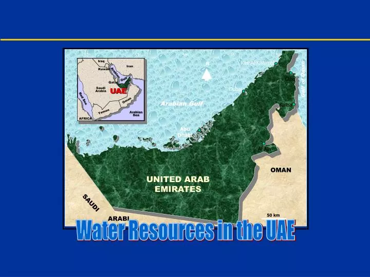
52o 53o 54o 55o 56o Iraq Ras Al Khaimah N Iran Kuwait Arabian Diba Gulf of Oman Gulf Qatar Dubai UAE Saudi Arabia Red Sea 25o Oman Arabian Gulf Kalba Yemen Arabian Sea AFRICA Abu Dhabi Al Ain 24o OMAN UNITED ARAB EMIRATES SAUDI 23o 50 km ARABIA Water Resources in the UAE
Water Resources - United Arab Emirates Water Resources in the United Arab Emirates • Summary • Objectives • Geomorphology • Mountains • Gravel Planes • Sand Dunes • Coastal Areas • Drainage Basins • Geology • Geologic Setting • Structural Conditions
Water Resources - United Arab Emirates • Climatic Conditions • Solar Radiation • Air Temperature • Relative Humidity • Evaporation • Evapotranspiration • Winds • Precipitation • Conventional Water Resources • Seasonal Floods • Springs • Falajes • Groundwater • Limestone Aquifers • Ophiolite Aquifers
Water Resources - United Arab Emirates • Gravel Aquifers • Sand Dune Aquifers • Non-Conventional Water Resources • Desalination Water • Treated Sewage Water • Water Problems • Depletion • Salt-Water Intrusion • Water-Quality Problems • Suggested Solutions • Modern Irrigation Techniques • Human Development • Modern Management Tools
Water Resources - United Arab Emirates Water Resources in the United Arab Emirates Because of the scarcity of water, the United Area Emirates rely on non-conventional water resources, in addition to conventional ones, to meet the ever-increasing demands for water (Table 1). Conventional Resources Include: • Seasonal Floods • Springs • Falajes • Groundwater Non-Conventional Resources Include: • Desalination Water • Treated Sewage Water
Water Resources - United Arab Emirates The mean annual runoff on the main wadis in UAE is 125 million m3. A large volume of runoff water is now harvested by 35 recharge dams with a total storage capacity of 75 million m3. A few dams are under construction at present and several others are planned in the future. The UAE permanent springs provide about 3.0 million m3 of water per year. Several seasonal springs with 22 million m3 annual discharge are claimed to exist by the Ministry of Agriculture and Fisheries. Despite their limited discharge, Falaj water is a renewable resource, which is directly related to rainfall. The total Falaj discharge in UAE varies between 9.0 x 10⁶ m3/yr in 1994 and 31.2 x 10⁶ m3/yr in 1982, which represents 2.8 to 9.7% of the total water use in the country.
Water Resources - United Arab Emirates The annual recharge for groundwater in UAE is 120 million m3, whereas the current annual groundwater extraction averages 880 million m3. The volume of desalinated water has increased from 7 million m3 in 1973 to 694 million m3 in 1998. In 1985, the desalination plants in UAE produced 204 million m3 of water, which represents 60% of the domestic water needs. In 1998, the production of desalinated water reached 526.6 million m3, which is 76% of the water used for domestic purposes. In 1997, the Abu Dhabi Emirate produced of desalinated water, The percentages of desalinated water production in 1997 was 57% in Abu Dhabi, 35% in Dubai, 5% in Sharjah, and 3% in the northern Emirates.
Water Resources - United Arab Emirates The sewage water discharge in UAE increased from 1.5 million m3 in 1973 to 142 million m3 in 1994. The sewage water discharge in UAE exceeded 175 million m3 in the year 2000. The most important water-related problems in UAE are the depletion of aquifers in several areas, such as Al Ain and Al Dhaid, saline-water intrusion problems, and water quality problems such as those associated with oil industry or agricultural activities. Improvement of the present water management in UAE can lead to water conservation, maintain better water quality, and restore deterioration aquifer systems in many areas of the country. The use of advanced irrigation technologies, construction of recharge dams, and growing salt-tolerant crops are proper agricultural approaches.
Water Resources - United Arab Emirates Location The United Arab Emirates lies in the southeastern part of the Arabian Peninsula between Latitudes 22° 40’ and 26° 00 ’N and Longitudes 51° 00’ and 56° 00’ E. The United Arab Emirates are bounded on the north by the Arabian Gulf and the Sultanate of Oman, on the east and northeast by the Sultanate of Oman and the Oman Gulf, and on the south and west by the Kingdom of Saudi Arabia (Figure 1). The mainland surface area of the United Arab Emirates is about 77,700 km2. Geomorphology and Geology The geomorphic features have a major role in controlling the movement of both surface and groundwater (Figure 2). Geology, on the other hand, encompasses the distribution of outcrops, stratigraphic sequences, and structural zones (Figure 3).
52o 53o 54o 55o 56o Iraq Ras Al Khaimah N Iran Kuwait Arabian Diba Gulf of Oman Gulf Qatar Dubai UAE Saudi Arabia Red Sea 25o Oman Arabian Gulf Kalba Yemen Arabian Sea AFRICA Abu Dhabi Al Ain 24o OMAN UNITED ARAB EMIRATES SAUDI 23o 50 km ARABIA Water Resources - United Arab Emirates Figure1. Location map of the United Arab Emirates
52o 53o 54o 55o 56o Ras Al Khaimah N Mountains Gravel Plains Linear Dunes, Star Dunes and Playa Deposits Ancient and Recent Dunes Coastal Sabkhas Diba Gulf of Oman Dubai 25o Kalba Arabian Gulf Abu Dhabi Al Ain 24o OMAN UNITED ARAB EMIRATES SAUDI 23o 50 km ARABIA Water Resources - United Arab Emirates Figure 2. Geomorphic Features of the United Arab Emirates.
52o 53o 54o 55o 56o Eolian Sand Surfacial Gravels Gypsum Deposits Sabkha Deposits Marl and Limestone Limestone, Marl and Sandstone Semail Ophiolite Hawasina Complex Musndam Limestone Hith Anhydrite and arab Formatin Triassic and Permian Rocks N QUATERNARY Ras Al Khaimah Diba Gulf of Oman TERTIARY Dubai Arabian Gulf CRETACEOUS 25o Kalba JURRASSIC Abu Dhabi TRIASSIC Al Ain 24o OMAN UNITED ARAB EMIRATES SAUDI 23o 50 km ARABIA Water Resources - United Arab Emirates Figure 3. Geologic Map of the United Arab Emirates.
Water Resources - United Arab Emirates These greatly influence runoff volumes, infiltration rates and surface and groundwater quality. Rainfall The principal rain in UAE falls between November and March, with the maximum intensity during February and March (Figure 4). About 90% of precipitation fall during winter and spring. The wettest months are February and March, when 60% of precipitation is received. February is the rainiest month with an average 37.9 mm while June is the driest month with an average of 0.3 mm (Figure 5). During wet years, there may be as many as nine rainy days during the winter months, although more than six days is not common.
Water Resources - United Arab Emirates The mean annual rainfall for the UAE is 110.7 mm (Figure 6). However, rainfall is extremely variable in space and time, depending on the climatic conditions, geographic location, local topography, and rainfall-driving mechanism. Rainfall is well over the average in the eastern and northeastern mountains followed by the eastern coast and gravel plains, below average along the western coast, and substantially lower in the western and southwestern desert regions (Figure 6). This figure also shows that the rainfall in UAE increases in the north and east and decreases in the south and west. A plot of the mean annual rainfall for the 1934-1996 period reveals cycles of about 10 years during which above average rainfall occurs (Figure 7). The importance of these cycles is that it produces enough rain that can contribute to groundwater recharge.
52o 53o 54o 55o 56o Buryrat Ras Al Khaimah N Falaj Al Mualla Diba Gulf of Oman Arabian Gulf Sharjah Airport Meleiha Dubai Dubai Airport 25o Kalba Al Hibab Al Hayer Abu Dhabi International Airport Sweihan Abu Dhabi Al Bateen Airport Al Oha Dalma Island Al Dhafra Al Ain Jebel Dhanna As Sila 24o Al Hamra Tarif Medinat Zayed OMAN Bu Hasa Al Wagan UNITED ARAB EMIRATES Medesis Asab Radoum SAUDI 23o 50 km ARABIA Water Resources - United Arab Emirates Figure 4. Major Meteorological Stations in the United Arab Emirates.
Mean for all Stations Extreme maximum Mean Minimum Rainfall (mm) Water Resources - United Arab Emirates Figure 5. Mean Monthly Rainfall in the United Arab Emirates.
Rainfall (mm) Mean Annual Rainfall Water Resources - United Arab Emirates Figure 6. Mean Annual Rainfall in the United Arab Emirates.
52o 53o 54o 55o 56o Buryrat Ras Al Khaimah N Falaj Al Mualla Diba Gulf of Oman Arabian Gulf Sharjah Airport Meleiha 180 Dubai 140 Dubai Airport Kalba 160 25o Al Hibab 140 Masfut Al Hayer Abu Dhabi International Airport Sweihan Abu Dhabi Al Bateen Airport 120 Al Oha Dalma Island Al Dhafra 100 Al Ain Jebel Dhanna As Sila 24o Al Hamra Tarif Medinat Zayed OMAN 80 Bu Hasa Al Wagan UNITED ARAB EMIRATES Medesis 60 Asab Radoum 40 SAUDI 23o 50 km ARABIA Water Resources - United Arab Emirates Figure 7. Iso-hyetal Contour map of the United Arab Emirates.
Conventional Water Resources • Seasonal Floods • Springs • Spring discharge • Water chemistry of springs • Falajes • Historical Perspective of falajes • Falaj Discharges • Chemistry of Falaj Waters • Groundwater • The Limestone Aquifers • Ophiolite Aquifer • Gravel Aquifers • Sand Dune Aquifers
Water Resources - United Arab Emirates Conventional Water Resources The conventional water resources in UAE include seasonal floods, springs, falajes and groundwater. Because these resources do not meet the demand for water in the country, non-traditional resources are now intensively used, especially desalinated water. There are no perennial surface water resources in UAE such as rivers or lakes. However, a few numbers of springs and several falajes provide a limited renewable supply of water. Estimates of the total annual volume of rainfall ranged from 700 to 1480 million m3. Optimistic figures suggest that 10% of this amount recharges groundwater every year; between 70 to 148 m3 with an average of 120 million m3.
Water Resources - United Arab Emirates Seasonal Floods Desert areas are known for flash flood. In UAE, these floods mostly occur in the eastern region in association with strong, short lasting, rain storms. Due to the low porosity and permeability of the prevailing igneous and metamorphic rocks, large amount of rainwater moves on land surface as surface runoff. This flow starts usually near the water divided and moves towards the Gulf of Oman in the east or desert in the west. The western region is dry and lacks surface runoff because of low rainfall (40 mm/year), high natural evaporation (3360 mm/year), scarce vegetation cover, and high porosity and permeability of dune-forming sands dominating this area.
Water Resources - United Arab Emirates Topographic map, aerial photographs, and satellite images show that the mountain range of the eastern region has 70 drainage basins, 58 of them are within UAE. The catchment areas of these basins vary between 5 km2 (Wadi Dhednah, Al Fujairah) and 500 km2 (Wadi Al Bih, Ras Al Khaimah). Some large wadis witness more than one runoff event every year, others may have surface runoff once every several years, and the rest of the wadis may remain dry for longer periods. The Ministry of Agriculture and Fisheries has constructed 35 dams across the outlets of several main wadis, with a total storage capacity of 75 million m3 in addition to their roles in protection against flood and recharging groundwater.
Water Resources - United Arab Emirates Topographic maps and satellite images in addition to the records of 5 stream gauges and 11 meteorological stations were used to estimate surface runoff and to assess flood potential of the major drainage basins in the Al Ain area, UAE (Figure 8). The calculated minimum annual rainfall that can produce surface runoff on drainage basins of the Al Ain area is about 75 mm in the Oman Mountains and 90 mm in Jabal Hafit. The annual average runoff volume ranges from 0.25 million cubic meters (MCM) in southwest Al Ain to 3.00 MCM in the northeast. The average annual runoff depth for the 1981-1991 period ranges from 5 mm in southwest Al Ain to 20 mm in the northeast (Figure 9).
56o 55o 56o N N Shaam 26o OMAN Arabian Gulf 26o Shaam Ras Al Khaimah 1 OMAN Arabian Gulf 2 Diba Gulf of Oman Gulf of Oman Umm Al Quwain 18 Ras Al Khaimah Ajman Sharjah 3 Dubai Diba Umm Al Quwain 4 Fujairah 19 Kalba 13 25o 5 6 Ajman 14 24 Khor Fakkan Sharjah 7 Water Divide 27 Dubai 9 17 UNITED ARAB EMIRATES 10 22 Fujairah 16 OMAN UNITED ARAB EMIRATES Kalba 15 8 25o Fold Fault Thrust Fault Fracture 12 23 24o OMAN Water Resources - United Arab Emirates Figure 8. Geologic Structures and drainage basins in the UAE.
Water Resources - United Arab Emirates Umm Al Quwain Umm Al Quwain 54o 55o 54o 55o 56o 56o N N Ajman Ajman 3.00 20 Sharjah Sharjah 25 2.50 15 30 Dubai Dubai 20 km 20 km 2.00 Arabian Gulf Arabian Gulf 1.50 1.00 0.50 10 5 25o 25o 0.25 Abu Dhabi Abu Dhabi OMAN OMAN 24o 24o Rainfall Intensity Runoff Volume Umm Al Quwain Umm Al Quwain 54o 55o 54o 55o 56o 56o N N Ajman Ajman Sharjah Sharjah 15 10 Dubai Dubai 20 km 20 km 12 20 18 Arabian Gulf Arabian Gulf 15 9 5 25o 25o 6 3 25o Abu Dhabi Abu Dhabi OMAN OMAN 24o 24o Runoff Depth Runoff Percent Figure 9. Rainfall-runoff relationship in major drainage basins of Al Ain area.
Water Resources - United Arab Emirates The percentage of rainfall as runoff varies between 3% in Jabal Hafit basins and 18% in the basins of the Oman Mountains. Based on the values of infiltration rate and length of overland flow, Wadi Sidr of the Oman mountains and Wadi Ain Al Faydah of Jabal Hafit have the highest flood potential, while Wadi Muraykhat and Wadi Al Ain West have the lowest flood potential (Figure 10).
55o 50’ 55o 50’ 55o 40’ 56o 00’ 55o 40’ 56o 00’ 56o 10’ 56o 10’ Risk of Flash Food Very Low Low Moderate High Very High Bifurcation Ratio (Rb) > 4.5 4.1 - 4.5 3.6 - 4.0 3.1 - 3.5 < 3.1 Infiltration Rate (Ir) Very Low Low Moderate High Very High Length of Overland Flow > 0.21 0.21 - 0.25 0.26 - 0.30 0.31 - 0.35 < 0.35 24o 30’ 24o 30’ N N 24o 20’ 24o 20’ 8 km 8 km Oman Mountains Oman Mountains 24o 10’ 24o 10’ Al Jaww Plain Al Jaww Plain Jabal Hafit Jabal Hafit 24o 00’ 24o 00’ Water Resources - United Arab Emirates Figure 10. Flash-flood potential and infiltration in major drainage basins in the Al Ain area.
Water Resources - United Arab Emirates Springs Spring are groundwater "outcrop“ or concentrated groundwater discharge at the ground surface. So, they are used as indicators of discharge areas in arid and semiarid regions. The UAE springs seem to discharge from local and intermediate groundwater flow-systems. Mineralized and thermal springs have therapeutic value. In UAE, several springs such as Khatt (Ras Al Khaimah), Maddab (Al Fujairah) and Bu Sukhanah or Ain Al Faydah (Al Ain) belong to this category, and have been utilized as recreational and touristic sites. The Khatt springs are located about 13 km east of Diba and 15 km south of Ras Al Khaimah, within hard limestone rocks of the Musandum Formation.
Water Resources - United Arab Emirates Siji spring lies at about 50 km west of Al Fujairah and 75 km east of Al Sharjah, on the contact between the ophiolite sequence and the western gravel plains. Bu Sukhanah spring is about 4 km west of Jabal Hafit, and south of Al Ain town. The spring issues from Miocene gypsum and clay layer through thin Quaternary loose sediments (Figure 11). Spring Discharge Records of spring discharge for the period 1984-1991 indicate that the Bu Sukhanah spring has the highest discharge (2.50 x 10⁶ m3/yr), whereas Siji spring has the lowest discharge (0.06 x 10⁶ m3/yr). Discharge of all springs shows wide variations during the 1984-1991 period, with a net increase of Khatt south and Bu Sukhanah springs and a net decrease of Khatt north spring.
Water Resources - United Arab Emirates Figure 11. Permanent springs in the United Arab Emirates
Water Resources - United Arab Emirates The discharge of Siji spring remained constant during the (1987-1991) period because of the construction of the Siji dam which maintained a steady and continuous groundwater recharge for the spring (Table 2). The studied UAE springs belong to the second (Bu Sukhanah), fourth (Khatt south and Khatt north) and fifth (Siji) orders. Water Temperature High-temperature water represents the most important physical property characterizing the studied UAE springs (40°C). It is believed that high-temperature water of springs is related to deep circulation of groundwater or presence of a radioactive source.
Water Resources - United Arab Emirates Table 2. Discharge of permanent UAE springs.
Water Resources - United Arab Emirates Waters of springs discharging from local groundwater flow systems are normally of low salinity and temperature close to the mean annual air temperature. In contrast, water of the springs discharging from regional groundwater flow systems can be highly mineralized with elevated temperatures. On this basis, it is concluded that Bu Sukhanah spring derives most of its water through a deeply circulating groundwater flow system that recharges far to the east from the northern Oman Mountains. This could explain the spring’s high-temperature water and high salinity. Black organic deposits were identified to contain 20.7 parts per million (ppm) Uranium along the joints and bedding plains of some calcareous rocks of Jabal Hafit.
Water Resources - United Arab Emirates Table 2. EC and TDS of permanent UAE springs.
Water Resources - United Arab Emirates The lack of these black deposits in some layers to its leaching by water discharging into the Bu Sukhanah spring. The heat associated with radioactive decay of uranium has contributed to the rise in the water temperature of the spring. Recent study on the Bu Sukhanah spring by the National Drilling Company and the U. S. Geological Survey indicates the presence of high radon activity. Water Chemistry The Total Dissolved Solids (TDS) content of water from the studied springs has increased since 1968 till now by 10% (Khatt south) to 50% (Bu Sukhanah).
Water Resources - United Arab Emirates This increase can be mainly attributed to intensive groundwater abstraction in recharge areas of these springs and low rainfall during the last few years. However, the increase in TDS content, from 5500 mg/l in 1977 to 10228 mg/l in 1994, of the Bu Sukhanah water with increasing discharge, from 0.96 x 10⁶ m3/yr in 1984 to 2.50 x 10⁶ m3/yr in 1991, requires further studies. The dissolution of evaporite deposits of the Miocene Fars Formation, through which the spring water moves, may contribute to the high-salinity water of the spring (Table 3). Concentrations of the major ions vary from one spring to another according to their local geologic and hydrogeologic conditions.
Water Resources - United Arab Emirates The 1991, 1992 and 1994 chemical analyses of water samples from the springs have indicated that there is a small increase in concentrations of all ions within the same spring, but, there is a great variation in concentrations of the same ion among different springs. Despite the fact that both the Khatt and Bu Sukhanah springs drain limestone rocks, chemical analyses of spring water samples show that the concentration of calcium-ion varies between 60 mg/l at Khatt south and 1100 mg/l at Bu Sukhanah in 1991. This reflects the difference in the groundwater flow systems feeding the springs. The water of the Khatt spring has a rapid circulation and direct relations to rainfall and water-table fluctuations.
Water Resources - United Arab Emirates Table 3. Electrical Conductance (EC) and SAR of UAE Springs.
Water Resources - United Arab Emirates In contrast, water chemistry of the Bu Sukhanah spring reflects a slow circulation and independent relations to rainfall and water-table fluctuations. Sodium-ion concentration varied between 2 mg/l at the Siji spring and 1600 mg/l at the Bu Sukhanah spring in 1991, reflecting the difference in the hydrogeologic conditions of both springs. The high sulphate-ion concentration of Bu Sukhanah spring suggests an old water source. In contrast, the high bicarbonate-ion concentration of Khatt springs suggests a recent water source. The relatively low bicarbonate-ion concentration in the Khatt springs (200 mg/l) in 1994 can be explained by a decrease in recharge rates, especially for the Khatt north spring.
Water Resources - United Arab Emirates Opposite to the wide variation in sulphate-ion concentration, chloride-ion concentrations show only a small increase in the Bu Sukhanah water between 1991 (4000 mg/l) and 1994 (4040 mg/l). The results of chemical analyses of water samples from the studied UAE springs show that all the spring waters are unsuitable for drinking purposes. A plot of the specific conductance in mohs/cm at 25°C against the Sodium Adsorption Ratio (SAR) indicate that, except for the water of the Siji spring, water of studied springs are not suitable for irrigating traditional crops. However, the waters can be used for irrigating specific crops in well-drained soils.
Water Resources - United Arab Emirates Falajes Until recently, falajes represented the main arteries of life in the eastern UAE. At their outlets palm oases have flourished, permanent communities were established, and an agricultural way of life was dependent upon their water. At the present time, many of UAE falajes have gone dry because of the low rainfall and excessive groundwater pumping. However, several falajes are still flow and feeding the same, but now larger, palm oases. The design, construction, and maintenance of active falajes are interesting features. Relics of water-distribution systems of historical falajes still exist near Al Hili archeological garden in the Al Ain area.
Water Resources - United Arab Emirates In 1998, I have studied the geological setting of UAE falajes, the factors affecting their discharge and water chemistry, the chemical characteristics of falaj waters and their suitability for different uses. Falaj Discharges During the period 1978-1995, the total falaj discharges in UAE varied between 9.0 x 10⁶ m3/yr in 1994 and 31.2 x 10⁶ m3/yr in 1982. Discharge varies from one falaj to another depending on the location of the main well (wells), nature of the source aquifer, the amount of seepage from tunnel sides, and the mean annual rainfall. Some falajes dry out during periods of low rainfall while others exhibit little effect.
Water Resources - United Arab Emirates Average discharges of UAE Falajes for the period 1984-1996 varied between 2.38 liter/second (l/sec) in Falaj Habeesa and 89.77 l/sec in Falaj Bithnah (L/B). According to discharge, falajes are classified into three types locally designated as Al Gheli, Al Daudi, and Al Hadouri (Al Adrous, 1990). Al Gheli falaj carries water only in winter and their discharge is directly dependent on rainfall (Table 4 ; Figure 12). Despite its limited amount, water of Al Gheli falajes is renewable and has a good quality. Because aquifers are main water source, Al Daudi falaj has a permanent discharge.
Water Resources - United Arab Emirates Table 4. Relationship of Falaj discharge to rainfall on the eastern mountain range (EMR) and gravel plans (GP).
Water Resources - United Arab Emirates Figure 12. Relationship of Falaj discharge to rainfall on the eastern mountain range (EMR) and gravel plans (GP).
Water Resources - United Arab Emirates Because of heavy groundwater pumping in many areas of the UAE, several falajes have gone dry. Historical discharge records of Al Ain falajes were obtained from Halcrow and Partners (1969), Gibb and Partners (1970) and the Ministry of Agriculture and Fisheries (1993).These records indicated that Al Jimi, Al Mu’waji, and Al Qattarah falajes went dry in 1979, whereas Al Mu’Tarrad, Maziad and Al Hili falajes dried out in 1981-1982. Because of continuous maintenance, extension, and pumping groundwater into their channels, Al Aini and Al Daudi falajes in the Al Ain area are still active in the present.
Water Resources - United Arab Emirates Chemistry of Falaj Waters The electrical conductivity (EC) of falaj waters varied between 450 S/cm in Falaj Asimah (Al Fujairah) and 10,940 S/cm in Falaj Ain Sukhnah (Al Ain). Generally, the EC values are low for water samples collected from the falajes draining ophiolite rocks, east of Al Ain and Al Fujairah areas, indicating low water salinity. In contrast, the EC values are relatively higher in water samples of the falajes draining limestone rocks in Ras Al Khaimah and west of Al Ain areas. The iso-EC contour map shows that the EC values of falaj waters are low near the water divide of the eastern mountains and increase further east and west, with distance from the recharge area (Figure 13).
55o 56o 55o 56o N N Shaam 26o Shaam 26o OMAN OMAN Arabian Gulf Arabian Gulf Ras Al Khaimah Ras Al Khaimah WDNA Diba Diba Gulf of Oman Gulf of Oman Umm Al Quwain Umm Al Quwain 1500 3000 750 6000 Ajman WDCN Ajman Masafi Sharjah Sharjah 750 Dhaid 750 Dubai Dubai Fujairah Fujairah Kalba Kalba WCA 1500 25o 25o 3000 EDSA 1500 UNITED ARAB EMIRATES UNITED ARAB EMIRATES 1500 Hatta OMAN 6000 3000 WDNA Western Drainage Northern Area WDCN Western Drainage Central Area WCA Western Coastal Area EDSA Eastern Drainage Southern Area OMAN 750 Al Ain Al Ain Area 24o 24o Water Resources - United Arab Emirates Figure 13. Locations of UAE falajes and EC of their waters.
Water Resources - United Arab Emirates The plot of the EC (S/cm) versus falaj length shows that the EC of water in open-channel falajes (Al Gheli type), which are dominant in the eastern mountain region, increase with increasing falaj length. The EC increase results from the high natural evaporation rates from falaj channels, interaction between water and the bedrock, and seepage losses. The longer the channel, the larger the contact surface with the bedrock, and thus, larger Total Dissolved Solids (TDS) contribution from the bedrock. Also, the longer the falaj channel, the larger the seepage losses. This explains why old falaj channels are very narrow and rather deep to minimize the natural evaporation from falaj waters (Figure 14).