Download

1 / 38
390 likes | 543 Vues
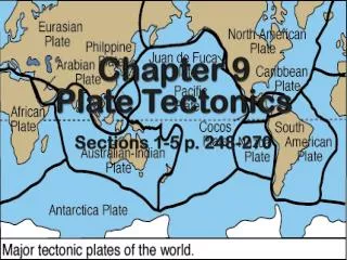
Chapter 2 - Plate Tectonics and Physical Hazards. The Big Picture. Pieces of Earth’s surface Move around Grind sideways Collide Sink into Earth’s hot interior Collisions create mountain ranges, cause tsunami Less directly, mountain ranges affect weather and climate.

E N D
The Big Picture • Pieces of Earth’s surface • Move around • Grind sideways • Collide • Sink into Earth’s hot interior • Collisions create mountain ranges, cause tsunami • Less directly, mountain ranges affect weather and climate
Development of the Theory • Continents drifted through oceanic crust continental drift • Fit across Atlantic is best using edges of continental shelves • Mountain ranges, rocks, fossils and glacial erosion patterns match across Atlantic • Glaciers existed in areas now warm and tropical • Unsure of the mechanism causing the drift Continents of Africa and South America fit together like puzzle pieces Alfred Wegener (1912) proposed supercontinent Pangaea The Origins of Continents and Oceans (1915)
Development of the Theory Wegener’s continental drift hypothesis was rejected because its mechanism (continents plowing through ocean floors) was deemed not to be physically possible More information about topography, appearance, age of ocean floor led to understanding of separation of continents Late 1940s through the 1960s: discovery of mid-oceanic ridges and the science of paleomagnetism
Development of the Theory • Harry Hess (1960): ocean floors act as conveyor belts carrying continents in process of seafloor spreading • New oceanic crust wells up at mid-oceanic ridges • Oceanic crust spreads away from ridges • Oceanic crust sinks into deep oceanic trenches at continents’ edges • Spreading rate calculated to be 2.5 cm/year • Whole Atlantic Ocean floor created in about 180 million years
Development of the Theory • Confirmation of seafloor spreading in mid-1960s • Alternating polarity of Earth’s magnetic field is recorded in basaltic rocks of ocean floors • Vine and Matthews (early 1960s) found striped alternating magnetic pattern, parallel to mid-oceanic ridge, representing bands of rocks formed at ridge in past periods of Earth’s switching magnetic field polarity • Came to be known as the Vine-Matthews hypothesis • Rocks at ridges found to be young (< 1 million years old); rocks at trenches much older
Development of the Theory • Seafloor spreading and other evidence supports theory of plate tectonics (describes movement of Earth’s plates) • Landmasses formed Pangaea 225 million years ago • Pangaea breakup moved continents into current positions
Development of the Theory Formulate (or re-test) Test Observe Hypothesize • Development of theory of plate tectonics as example of scientific method • Logical analysis of data to solve problems • Scientists make observations, develop tentative explanations (hypotheses) • Hypothesis must be testable • Tests and observations lead to acceptance, revision or rejection of hypothesis • If hypothesis continues to be supported by evidence over long time, it becomes a theory • Wegener’s continental drift hypothesis was modified to become theory of plate tectonics
The Earth’s Interior Structure • Three main regions • Core • Mantle • Crust • These are broken down into sub-regions
The Earth’s Interior Structure • Core • Inner Core • Outer Core • Mantle • Lower Mantle • Upper Mantle • Asthenosphere • Uppermost Mantle • Crust • Lithosphere
The Earth’s Outer Core Guttenburg discontinuity • About twice as thick as the inner core, but less dense • Composed of liquid iron (nickel-iron alloy) • Not under as much pressure as the inner core • Responsible for the wobble of Earth's rotation (termed Chandler’s wobble) • This is where the Earth’s magnetic field is thought to be generated
The Earth’s Mantle • Earth’s Mantle (80% of earth’s total volume) • Lower Mantle: denser iron and silicates • Upper Mantle: distinct layers • Upper Mantle • Asthenosphere • Uppermost Mantle
The Earth’s Mantle • Upper Mantle – olivine materials • Asthenosphere – heated rock that is softer and is less dense, and allows tectonic movements, surface folding • Radioactive decay • Plastic layer • Uppermost Mantle – Rigid, next to crust transmits seismic waves to surface
The Lithosphere and Crust From the surface to ~43 miles down Comprised of the uppermost mantle and the crust Lithosphere is stiff, rigid outer rind of Earth, which makes up plates from 60 km (oceanic) to 200 km (continental) thick, including crust and denser underlying mantle
Earth Structure • Boundary between crust and mantle identified as density difference • Mohorovicic Discontinuity (Moho) • Boundary between lithosphere and asthenosphere has been identified as zone of lower velocity for seismic (earthquake) waves traveling through mantle: low-velocity zone (LVZ)
Earth Structure Note how close the LVZ is to the surface in oceanic locations as opposed to continental crust
Earth Structure • Continental crust • Silica-rich • Low density 2.7 g/cm3 • 30-50 km thick • Stands higher than denser oceanic crust • Oceanic crust • Iron-, magnesium-rich, silica-poor • Higher density 3.0 g/cm3 • 7 km thick • Floats lower than continental crust, on top of denser mantle
Earth Structure • Elevation difference between continental and oceanic crust explained by isostacy • Floating solid object displaces liquid of same mass • Crust (continental or oceanic) floats atop mantle (denser mantle slowly flows away to accommodate crust)
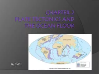
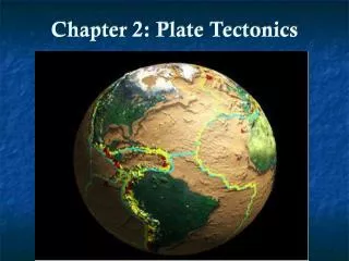
Earth Structure • Lithosphere is broken into about 12 large plates, most of which are combination of continental and oceanic areas, moving up to 11 cm/year • Plates move away from each other at divergent boundaries – usually mid-oceanic ridges • Plates move toward each other at convergent boundaries • Subduction zone: one plate dives under other, into mantle • Continent-continent collision: low density of continents prevents subduction, crumple up into each other instead • Plates slide past each other at transform boundaries
Earth Structure Lithosphere is broken into about 12 large plates, most of which are combination of continental and oceanic areas, moving up to 11 cm/year
Earth Structure Three types of boundaries, divergent, convergent and transform, found at western edge of North America
Hazards and Plate Boundaries Most earthquake and volcanic activity occurs at plate boundaries Subduction zones between oceanic and continental plates along Pacific coasts Collisions between continents in mountain belts of southern Europe and Asia Rapidly spreading divergent boundaries follow mid-oceanic ridges Slowly spreading divergent boundaries pull apart continents (East African Rift zone)
Divergent Boundaries • Plates pull apart (by sinking of heavy lithosphere at trenches) • System of connected oceanic ridges through ocean basins • Only above sea level at Iceland • Fissures open every 200-300 years in Iceland’s central valley, erupting large basalt flows • Spreading centers are source of basalt that covers all ocean floors, 2/3 Earth’s surface • Little volcanic or earthquake hazard
Convergent Boundaries • Subduction zones – where two plates meet, denser (oceanic) plate slides beneath other and sinks into mantle • Contact zone sticks then slips, in huge earthquakes • Sudden movement of ocean floor can generate tsunami • Line of volcanoes forms inland from subduction trench • After being subducted, water-rich serpentinite heats up and breaks down, releases water • Released water rises into mantle, causes partial melting • Basalt magma rises to surface to form volcano • If basalt magma rises through continental crust, mixes to form rhyolite magma
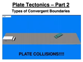
Collision of Continents • Neither plate sinks (too light to penetrate mantle) • High mountains are pushed up • Accompanied by large earthquakes • Forms Himalayas, Tibetan plateau, Caucasus
Transform Boundaries • Plates slide past each other without pulling apart or colliding • Oceanic transform faults offset mid-oceanic ridges • Direction of offset does not indicate relative movement on transform fault • Transform faults on continents generate large earthquakes, near large population centers • North Anatolian fault in Turkey • San Andreas fault in California
Hotspot Volcanoes • Volcano is surface expression of hotspot: • Column of hot, partially molten rock rising through mantle, burning through overlying moving plate, to form track of volcanoes, far from plate boundary • Hotspot volcanoes erupt at active end of chain of extinct volcanoes, which get progressively older farther from active end • Hawaiian-Emperor chain in Pacific, Yellowstone line of resurgent calderas • Columns of hot rock (plume) appear fixed in mantle • Hot rock melts near surface as pressure drops
Review of Chapter 2 • The Earth is not a solid mass • It has layers • Composition differs • Most importantly, the surface is not cohesive • 12 large plates are in motion • We see surface expressions, but a very complex system is operating below the crust • That complex system of motion is the driving geophysical force for the hazards and disasters we will study over the next seven chapters • After Chapter 7, tectonics plays very little role in what we will examine