Download
1 / 19
220 likes | 529 Vues
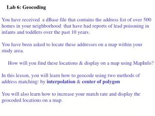
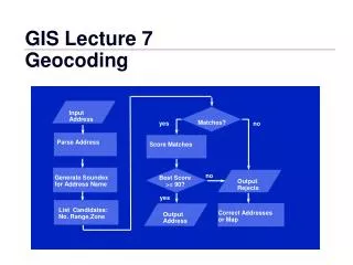
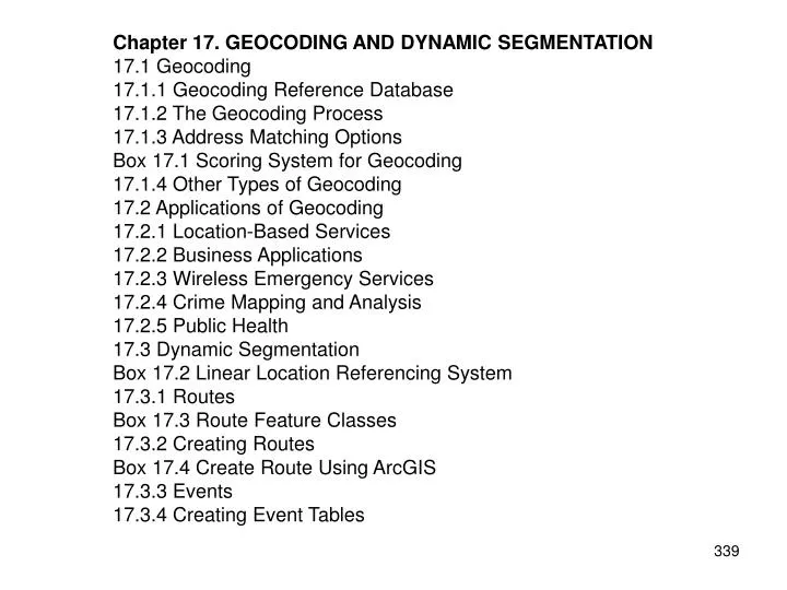
Chapter 17. GEOCODING AND DYNAMIC SEGMENTATION 17.1 Geocoding 17.1.1 Geocoding Reference Database 17.1.2 The Geocoding Process 17.1.3 Address Matching Options Box 17.1 Scoring System for Geocoding 17.1.4 Other Types of Geocoding 17.2 Applications of Geocoding 17.2.1 Location-Based Services

E N D
Chapter 17. GEOCODING AND DYNAMIC SEGMENTATION 17.1 Geocoding 17.1.1 Geocoding Reference Database 17.1.2 The Geocoding Process 17.1.3 Address Matching Options Box 17.1 Scoring System for Geocoding 17.1.4 Other Types of Geocoding 17.2 Applications of Geocoding 17.2.1 Location-Based Services 17.2.2 Business Applications 17.2.3 Wireless Emergency Services 17.2.4 Crime Mapping and Analysis 17.2.5 Public Health 17.3 Dynamic Segmentation Box 17.2 Linear Location Referencing System 17.3.1 Routes Box 17.3 Route Feature Classes 17.3.2 Creating Routes Box 17.4 Create Route Using ArcGIS 17.3.3 Events 17.3.4 Creating Event Tables
17.4 Applications of Dynamic Segmentation 17.4.1 Data Management 17.4.2 Data Display 17.4.3 Data Query 17.4.4 Data Analysis Key Concepts and Terms Review Questions Applications: Geocoding and Dynamic Segmentation Task 1: Geocode Street Addresses Task 2: Display and Query Routes and Events Task 3: Analyze Two Event Layers Task 4: Create a Stream Route and Analyze Slope Along the Route Task 5: Locate Cities Along U.S. Interstate 5 Challenge Question References
Figure 17.1 A sample address table records name, address, and ZIP code.
Figure 17.2 The TIGER/Line files include the attributes of FEDIRP, FENAME, FETYPE, FRADDL, TOADDL, FRADDR, TOADDR, ZIPL, and ZIPR, which are important for geocoding.
Figure 17.3 Linear interpolation for address geocoding.
Figure 17.4 Address geocoding plots street addresses as points on a map.
Figure 17.5 The end offset moves a geocoded point away from the end point of a street segment, and the side offset places a geocoded point away from the side of a street segment.
Figure 17.6 An example of Intersection matching.
Figure 17.7 An example of a route subclass using the coverage model. See text for explanation.
Figure 17.8 An example of a geodatabase route feature class.
Figure 17.9 The interactive method requires the selection or digitizing of the line segments that make up a route (shown in a thicker line symbol).
Figure 17.10 Interstate highway routes in Idaho.
Figure 17.11 An example of a split route.
Figure 17.12 A looping route divided into three parts for the purpose of route measuring.
Figure 17.13 An example of converting point features to point events. See text for explanation.
Figure 17.14 An example of creating a linear event table by overlaying a route layer and a polygon layer. See text for explanation.
Figure 17.15 The thicker, solid line symbol represents those portions of the Washington State’s highway network that have the legal speed limit of 70 miles per hour.
Figure 17.16 Data query at a point, shown here by the small circle, shows the route-ID, the x- and y-coordinates, and the measure (m) value at the point location. Additionally, the beginning and ending measure values of the route are also listed.
MapQuest http://www.mapquest.com/ Tele Atlas http://www.teleatlas.com/ CrimeStat http://www.icpsr.umich.edu/NACJD/crimestat.htm Washington State Department of Transportation GIS Data http://www.wsdot.wa.gov/mapsdata/geodatacatalog/default.htm ESRI’s geodatabase website http://support.esri.com/datamodels U.S. Census Bureau http://www.census.gov National Hydrography Dataset: NHDinGEO http://nhd.usgs.gov/geodatabase_review.html