Download
1 / 22
310 likes | 643 Vues
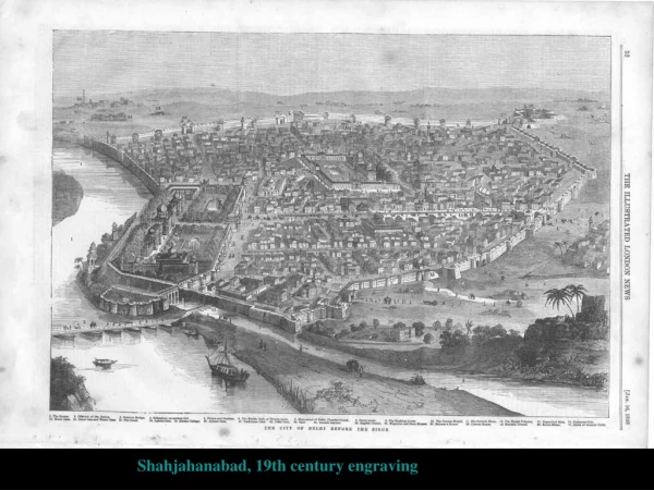
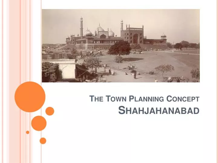
The Town Planning Concept Shahjahanabad. DELHI – THE MUGHAL CAPITAL. Delhi is a city that has seen both glory and destruction in its long. It has been plundered, ruined time and again only to spring from its ashes to become the capital of powerful dynasties.

E N D
DELHI – THE MUGHAL CAPITAL Delhi is a city that has seen both glory and destruction in its long. It has been plundered, ruined time and again only to spring from its ashes to become the capital of powerful dynasties. Fortunately, the resilient and enduring culture and heritage has withstood the test of time and the city continues to live. The heart of Delhi can be found in Old Delhi, 350 yrs old, yet strong and beating. Its many-branched arteries are narrow with age, its veins jostle for space, and its lifeblood is bound to get clotted at some places at any time. No city reflects the endless drama of change better.
Introduction - SHAHJAHANABAD • By the time the emperor Shah Jahan (1928-58) came to the throne, the Mughal empire had ruled continuously over northern India for almost a century and the artistic tradition of Mughals had reached a stage of maturity and refinement. During Shah Jahan’s rein the architectural development was remarkable due to his interest and patronage of architecture. His buildings were characterized by sensitivity and delicateness.
Background • The Mughal period from Akbar ( 1566-1605) to Shah Jahan was comparatively long and peaceful; it was marked by the development of cities. Shah Jahan established residences in Lahore, Agra and Delhi. In 1638, he laid the foundations of new capital, centered around Lal Qila or Red Fort. This was an improvement on the citadel in Agra, because of the experienced gained by Shah Jahan, where limited space and narrow streets made it difficult for the processions of his troupes. • The site for the new capital in Delhi was ideally suited as a convergence point of land routes, being centrally located geographical. The site was situated on the western bank of river Yamuna where a natural projection formed a triangle with the land and the river.
Muslim Urban Life • By Shah Jahan’s time, the Muslims in India had partially Indianized. • Under the Mughals, they were mainly an urban community, and they disliked village. Muslim life was closely linked to religious event, as well as to ceremonies and festivals or ritual events. • Shah Jahan was a religious person and was very particular about observing ceremonies. On the morning of the most important Muslim festival Eid-i-Qurba (the fest of the sacrificed), Muslims go to Id-gah, or place of prayer, generally situated outside the city or village in an open space. The Id-gah of Shahjahanabad is located on the crest of the ridge, west of the city.
Spatial Structure • Urban spatial structure of Shahjahanabad was different from that of the other Mughal Capitals, because it was planned and built by one concentrated planning effort. • Creation of architectural expression of what has often been called the patrimonial system in its climax. • The shurafaur ignited from the qasbah garrison posts & admn. settlements in which Islamic scholars also met their clients & where an integrative or even syncretists cultured prevailed – usually established around a tomb or a waqf . • The shurafa usually were situated to the west of the place, along one of the two boulevards at Chandni Chowk, & originated from the employer’s palace, thus furnishing the city with an unequivocal structure. • Those professional groups delivering fresh agrarian products to the city must have settled along the southern and south-south-western rim of the city walls (Delhi gate & Turkman gate): this is where institutions , such as Masjid gadarion (shephered’s mosque), Masjid kasai (butcher’s mosque) were located. They all represent “low ranking traders”. • The closer to the core of the city the more socially recognized are the professional settled there: weavers, producers of wool, traders of saddle- horses, oil- extractors & manufacturers of straw goods, each of them represented by their respective mosques. • Further, in the direction of Chandni Chowk, mostly representative of the trading professions, e.g. traders of fabrics, fish, meats and luxury goods, but also some of the professional groups processing goods, e.g. producers of water pipes can be found, all of them are characterized by the spatial proximity to the imperial house.
Planning of Shahjahanabad • The city was planned according to hind planning principles of shilpashastra from vastushastra. • The site was placed on a high land as in the shastra and was kamukha or bow shaped, for this ensured its prosperity. • The arm of the archer was Chandni Chowk. • The string was Yamuna river. • The junction of the two main axes is the most auspicious point in the whole region and was therefore the red fort.
The city form- morphology elements • The urban infrastructure was laid out in a geometric pattern. • Shows traces of both Persian and Hindu traditions of town planning and architecture with the Persian influence largely accounting for the formalism and symmetry of the palaces gardens and boulevards. • The designed infrastructure of Shahjahanabad comprised- • The fort • The Friday mosque. • The other major mosques, including the corresponding waqf properties. • The two main boulevards. • The bazaars around the Friday mosque. • The elaborate system of water channels. • The major gardens and the city wall. • The arrangement of these planned elements was influenced by certain site features, which precluded absolute geometry.
The Fort & The Mosque • The Red Fort and Jama Masjid were thorough fares that framed the city. • From Lahore Gate ran a broad avenue with a covered arcade designed and paid for by Jahan Ara- that housed over 1500 shops. Today known as Chatta Bazaar. • The remainder of Shahjahanabad took shape within the city walls with its havelis mansions, mosques, temples, Sikh shrines and the gardens of the nobility. • The walled and guarded establishments of these grandees included private living quarters for the nobles and their harem.
The Red Fort (Palace Complex) • The plan of the fort was made by Shah Jahan and two Muslim architects. The foundation stone of the fortified place was laid in 1638. Construction work began in 1639 and was complete in just nine year. The palace complex, located along the western river front was built as an ideal residence for the emperor, it was conceived and designed as a paradise on Earth. The layout of the fort was drawn on a formal geometrical plan actually an irregular octagon with two long sides on east and west. It had two gates, that on the west was called the Lahori Darwaza, while that on the south was the Delhi Darwaza. Bearing on the cardinal points, the elements of the fort were arranged in the geometrical pattern that reflected the life and customs of Mughal court.
Jami Masjid • The Jami Masjid was the principal mosque of the capital, the congregational centre and one of the most important institutions for the Muslims in Shahjahanabad. Shah Jahan commenced building the mosque in 1650, and completed it 6years later. It was located at the central part of the city and on a raised foundation at the top of a hill 9mts above the street level. • The mosque dominated the walled city as a visual as well as a spiritual symbol of supreme god. Its architectural design followed by traditional style, but improvements were made here as well. Te courtyard was large and was enclosed by pillared corridors. Its layouts, having a main entrance on the east, was geometric and the whole mosque faced west towards Mecca. Muslim urban life was closely evolved around the Jami Masjid.
Major Streets • The streets in Mughal capital were usually narrow and crooked. However, the major streets in the new capital were designed as wide and straight. The east-west street called Chandni Chowk connected the Lahori Darwaza of the fort to the Lahori Darwaza of the city wall. It ran in a straight line forming a wide boulevard with broad vista. The Fort was visible from any place on the street. This perspective view marked a new concept of town planning for the Mughal capital. Chandni Chowk is 1.4km in length and jogged right at the Fatehpuri Begum Mosque. It was built as the central axis of the city. Karawan Sarai and begum ki Sarai were also located in this area. • Another main street the Faiz Bazaar or Akkarabadi Bazaar, was also wide and straight. It had a north-south axis and connected Delhi gate of the fort with the city walls Delhi gate and is about 1km in length. These major two streets developed as processional routes, as well as commercial arteries. The streets also assumed importance for ritual events.
Five Main Streets • The basic network of the five main streets extended from Chandni Chowk and Faiz Bazaar to other gates and to different part of the walled city. The streets were built as the spines of major activities and developed as commercial thorough affairs. They connected the Ajmeri Darwaza with the Jami Masjid and Turkman and Lahori Darwazas. Their intersections formed a landmark. Important buildings were located on these arteries. The other streets were less significant and were mainly built as access roads to the residential areas. Mahalla / Katra • There was a tendency of the cities' population to settle by ethnic affiliations and to live in the same neighborhoods. The urban community and the Mughal capital was formed by such districts or wards, known as mahallas and katras. These homogeneous units also define cultural as well as socio-economic activities. There were 36 mahallas in the walled city. Each katra had an enclosed space created between residential and commercial buildings having entry to a katra made through a gate. • These courtyards were environmentally sound and acted as main ventilation shafts in a hot and arid climate. Communal open space was conspicuously absent as it is so today. There was not much need for communal open space, other than for worship which is why the Jami Masjid was provided with a spacious courtyard. • Thus, it is clear that planning of a residential area in the Mughal capital did not provide for social units.
Streets, Bazaars, Chowks • The city was separated from the surrounding land by a wall and a moat. Passing through the city’s gates marked the passage from one domination to another. The main thoroughfares , the secondary roads and the bazaars were public space. Havellis • The members of the imperial household whio lived outside the fort/ palace built large mansions (havellis) on the model of the imperial design of the red fort. As a rule these city palaces accommodated not only the owner and his family, but also their numerous followers, servants, and craftsmen with their workshops. The internal organisation of the space within the havellis was therefore also based on the strict distinction between the public, semi private and private spaces. Interior courtyard of a Havelli in the walled city • Notice the spill out of day to day activities in the courtyard- thus the typology was not only suited climatically but also enhanced the living.
Streetscapes • There emerges a hierarchy of streets in the layout of the city. • The secondary streets were the ones which entered the south of the city from Chandni Chowk. (thus they were perpendicular for some distance and then assumed an organic form once deep in the city). • The secondary street structure also includes the streets that are parallel to the city walls- forming a concentric ring so to say, in the southern part of the city. They then intermingle at chowks with the third layering of streets, which derive their character from the fact that they are perpendicular to the main mosque, Jama Masjid.
Bagh • The north area of Chandni Chowk was occupied by a bagh called the Jahanara Begumi’s Garden. It was laid out in a planned fashion, in addition to the road planning of Chandni Chowk. City Walls • The layout o the city walls was based on a geometrical planning; i.e. to say, a polygonal plan with gateways. The four main gates were Delhi Darwaza on south, the Ajmeri Darwaza on the south-west, the Lahori Darwaza on the west and the Kashmiri Darwaza on the north. These important gates were positioned according to the basic network of the city, being laced on the cardinal points. The graphic representation of the city was indicated geometric planning and the geometric placement of the main gates.
Conclusion • The new Mughal capital and the fort were designed as an ideal city and a paradise on Earth. • The design and planning methods were geometric and provided for green areas (gardens) and water facilities. • Principal elements in the town planning were the fort, the Jami Masjid, two major streets, city wall and gates, the Bagh, the Id-gah and the Karawan Sarai. • The Red fort was designed as a symbol of Muslim power and as an ideal living space on a formal geometrical plan. • The Jami Masjid was designed as a symbol of Muslim power and of the capital. • Two major streets were developed as the central axis and as processional routes and they were new elements in the capital; the design and the planning method was a new concept in town planning in the Mughal capital. • Planning in the capital did not provide planning of residential areas. • The city wall and gateways were drawn on a geometrical plan. • Urban forms and patterns developed on there own in response to the emperor’s basic need and idea and little attention was paid to the social planning.