Download
1 / 47
480 likes | 963 Vues
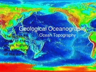
Geological Oceanography. Plate Tectonics Part 2. Plate Tectonics. How do we know that there are plates and that they move? Earth’s lithosphere is broken up into plates Plates are in motion and continually changing in shape and size. Earthquake Distribution. Lithospheric Plates.

E N D
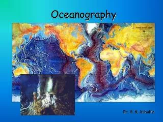
Geological Oceanography Plate Tectonics Part 2
Plate Tectonics • How do we know that there are plates and that they move? • Earth’s lithosphere is broken up into plates • Plates are in motion and continually changing in shape and size
Plate Tectonics • Plate boundaries • All major interactions among individual plates occur along their boundaries • Types of plate boundaries • Divergent plate boundaries • Convergent plate boundaries • Transform fault boundaries
Plate Tectonics • Divergent Plate boundaries • Most are located along the crests of oceanic ridges • Also continental rifts • One presently is on land
Divergent boundaries are located mainly along oceanic ridges
Ridges and Rises Figure A is a cross-sectional view of the fast-spreading Mid-Atlantic Ridge. Figure B is a cross-sectional view of the fast-spreading East Pacific Rise. On both cross sections, vertical exaggeration is 50 times normal.
Plate Tectonics • Convergent Plate Boundaries • Where two plates collide • Types of convergent boundaries • Oceanic-continental convergence • Oceanic-oceanic convergence • Continental-continental convergence
Plate Tectonics • Transform fault boundaries • Plates slide past one another • No new lithosphere is created or destroyed • Transform faults • Most join two segments of a mid-ocean ridge as parts of prominent linear breaks in the oceanic crust known as fracture zones
Plate Tectonics • Hot Spots • Caused by rising plumes of mantle material • Volcanoes can form over them (Hawaiian Island chain) • Most mantle plumes are long-lived structures and at least some originate at great depth, perhaps at the mantle-core boundary
Divergent Plate Boundaries: Juan de Fuca Ridge
Juan de Fuca Ridge • A spreading center ~500 km (300 miles) long • medium spreading rate (5-10 cm/yr) = 50-200 m deep rift • The rift is only 5 km across. Cross-section of East Pacific Rise at 21 degrees N from Macdonald (1982). Vertical exaggeration = 4x.
Divergent Plate Boundaries: Iceland
Iceland • Straddles the Mid Atlantic Ridge • Iceland is between the North American and Eurasian Plates • Two zones of spreading and volcanism • An eastern zone, the site of most historical eruptions • A western zone.
Surtsey • Episodic eruptions began on November 8, 1963 • The volcano grew from the sea floor, at a depth of 130 m, to sea level by November 15 • Initial eruptions were explosive, then changed to gentle basalt flows. • The eruption stopped on June 5, 1967
Divergent Plate Boundaries East African Rift Zone
East African Rift Zone • Rifting between the African Plate and the Arabian Plate • “triple junction” • May eventually form the next major ocean
Convergent Plate Boundaries The Cascades
Cascades Range • Active for about 36 million years • Convergence continues at about 4 centimeters per year • Not a typical subduction zone, • Very little seismic evidence of active subduction • There is no trench • Only evidence for ongoing subduction is the existence of volcanic activity
Japan • Most volcanoes result from subduction of westward-moving oceanic crust under the Asian Plate (continental crust). • The volcanoes of this region are unusually explosive • In the Izu-Marianas chain, the crust to the west is also oceanic, forming island arcs with mostly basaltic volcanoes
The Himalayas: Two continents collide • 225 million years ago, India began to move north towards Asia • Collision occurred 40 – 50 million years ago. • The Himalayas and the Tibetan Plateau to the north have risen very rapidly • After India collided, Australia was released from Antarctica and it began to move northward towards S. E. Asia. • Australia is currently in collision with Asia.
Transform Plate Boundaries The San Andreas Fault
San Andreas fault zone connects the East Pacific Rise in the south, with the South Gorda - Juan de Fuca - Explorer Ridge to the north • 1,300 km long and in places tens of kilometers wide • Pacific Plate has been grinding horizontally past the North American Plate for 10 million years, at an average rate of about 5 cm/yr
Movement can occur either in sudden jolts or in a slow, steady motion called creep. • Great San Francisco Earthquake (8.3-magnitude) in 1906 ruptured along a previously locked 430 km-long segment of the San Andreas • The magnitude-7.1 Loma Prieta earthquake of October 1989 occurred along a segment of the San Andreas Fault which had been locked since the great 1906 San Francisco earthquake
Hot Spots Hawaii
The Hawaiian Ridge – Emperor Seamounts chain extends 6,000 km • Contains more than 80 volcanoes • Sharp bend in the chain indicates a change in plate about 43 million years ago • Oldest islands are being subducted in the Aleutian Trench • Youngest is Lo’ihi
Lo`ihi Seamount • Located south of Kilauea about 30 km from shore • 969 m below sea level • 3000 m high • Generates frequent earthquake swarms, the most intense of which occurred in 1996. • High-temperature hydrothermal venting at its summit (200 ° C ) • Water normally 77 ° C Tour of Lo’ihi
Hot Spots Yellowstone
Facts: • Location: Wyoming, Montana, Idaho • Height: 2,805 Meters • Latest Eruptions: 70,000 years ago • Yellowstone hot spot active for as long as 17 million years.
Catastrophic eruption = calderas • Most recent: 650,000 y.o. • Produced a 53 x 28 mile caldera