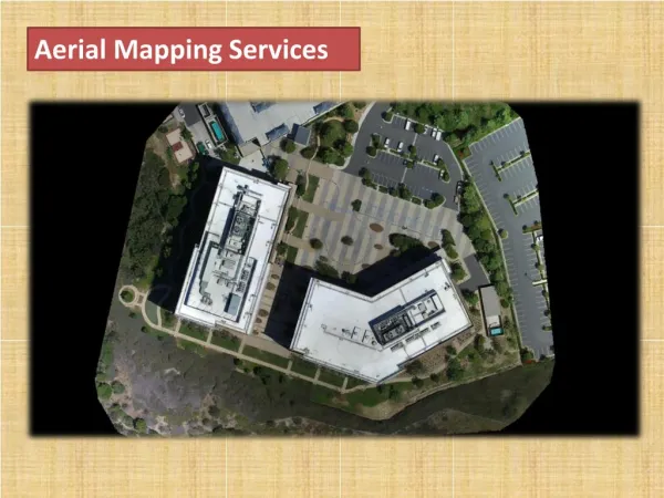
Aerial mapping drone
The flexibility of aerial mapping drone makes them a reliable tool in the industrial projects be it for mapping or any other aerial inspections.


Aerial mapping drone
E N D
Presentation Transcript
All You Need to Know About Aerial Surveying Drone & Their Benefits Accountants use calculators, carpenters use electric drills, and surveyors are using GPS, infrared reflectors, and many more tools. However, drone technologies might change how land surveyors conduct their survey from the sky instead of the land. If you have a project where you need to hire an aerial mapping drone service, here is everything you need to know. What Is a Drone Survey? The exact science of determining the location of points in 2D and 3D space and their distances are surveying. Surveys offer vital evidence that helps informed decision-making from building site planning, infrastructure design and maintenance, cadastral land boundaries to delineation, and more.
A drone survey is essentially a survey performed using a drone from above instead of the land. Use Cases by Industries Construction Drone mapping helps the building industry tremendously. Maps may be used to inform construction industry clients daily on the status of their designs, evaluate supplies of raw materials such as soil and gravel, or even create 3D construction site templates. These maps help building management acquire the “big picture” and help in strategic decision-making. Land Surveying A significant beneficiary of aerial mapping is land surveyors. To define borders, their task is to take accurate measurements on pieces of property. The details they compile helps to construct maps, charts, and legal documents. There is no question that drone photogrammetry will be useful for their career, with maps as a vital part of their work. Real Estate To help in the selling of land, aerial maps are useful. In deciding whether the property is correct for them, and the up-to-date aerial map will be of great use for those contemplating purchasing vast areas of real estate. If you’ve ever looked at a regular satellite picture, you know that there’s always a lack of clarity. Drone mapping services should solve the problem of visibility. Mining The mining industry is one field that is now promoting drone mapping. Among various other applications, up-to-date and accurate maps are used to control supplies, water drainage, erosion detection, and pit and dump management. Constantly modified maps will provide greater situational information for administrators and can aid in decision-making.
Forestry For the forestry sector, drone imaging may also be useful. Illegal deforestation can be observed and tracked with accurate maps, tree numbers can be determined, and forest health can be controlled. Benefits Drone Mapping Safety Land surveyors’ job is mostly outside, regardless of the temperature, which requires a lot of endurance and probably lengthy commutes. An extra danger of difficult or unforeseen terrain is also present. With a drone mapping solution for autonomous flights, most hazards associated with land surveying, such as heavy machinery and dangerous accidents, are removed. Speed Drone mapping takes minutes instead of days or weeks to complete a site survey with the same precision that you can do on foot. Budget The advantage of drone technologies is that you most definitely have a budget already. Drone mapping can suit the pre-existing project allocations smoothly. It can also maximize the budget of the business and time to spend on other activities. Only Tool Land surveyors will also use drones that autonomously pilot with the press of a button instead of theodolites, infrared reflectors, and GPS.