
FCAA01
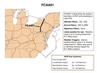
FCAA01. FCAA01 is defined by the western boundary of ZNY and extending to Lake Erie. Altitude Filters: 120 – 600 Arrival Filters: ZNY & ZBW Departure Filters: None Likely weather for use: Weather close in to or moving toward the N.Y. Metro area.

FCAA01
E N D
Presentation Transcript
FCAA01 FCAA01 is defined by the western boundary of ZNY and extending to Lake Erie. Altitude Filters: 120 – 600 Arrival Filters: ZNY & ZBW Departure Filters: None Likely weather for use: Weather close in to or moving toward the N.Y. Metro area. Weather Triggers: Intense weather that is close in or moving toward the N.Y. Metro area and is or will likely directly impact the N.Y. Metro airports. FCAA01 NESP Rate Guidelines Flow through ZOB: Low Weather Impact: 90 – 100 Rate/Hour Med Weather Impact 80 – 90 Rate/Hour High Weather Impact 70 – 80 Rate/Hour
FCAA02 FCAA02 is defined by the northern boundary of ZDC from MRB extending southeastward. Altitude Filters: 120 – 600 Arrival Filters: ZNY & ZBW Departure Filters: None Likely weather for use: Weather close in to or moving toward the N.Y. Metro area. Weather Triggers: Intense weather that is close in or moving toward the N.Y. Metro area and is or will likely directly impact the N.Y. Metro airports. FCAA02 NESP Rate Guidelines Flow through ZDC: Low Weather Impact: 100 – 110 Rate/Hour Med Weather Impact 90 – 100 Rate/Hour High Weather Impact 80 – 90 Rate/Hour
FCAA03 FCAA03 is defined by the western boundary of ZOB and the eastern boundary of ZID. Altitude Filters: 120 – 600 Arrival Filters: ZNY & ZBW Departure Filters: None Likely weather for use: Weather in the Ohio Valley region would likely trigger use of this FCA. Weather Triggers: Lines and popcorn storms. CCFP predicted intensity levels of greater than 50% with High Confidence. FCAA03 NESP Rate Guidelines Flow through ZOB: Low Weather Impact: 70 – 75 Rate/Hour Med Weather Impact 60 – 70 Rate/Hour High Weather Impact 50 – 60 Rate/Hour
FCAA04 FCAA04 is defined by the entire western and southern boundary of ZDC. Altitude Filters: 120 – 600 Arrival Filters: ZNY & ZBW Departure Filters: None Likely weather for use: Weather in the Ohio Valley region or in ZDC airspace. Weather Triggers: Lines and popcorn storms. CCFP predicted intensity levels of greater than 50% with High Confidence. FCAA04 NESP Rate Guidelines Flow through ZDC: Low Weather Impact: 65 – 70 Rate/Hour Med Weather Impact 55 – 65 Rate/Hour High Weather Impact 50 – 55 Rate/Hour
FCAA05 FCAA05 is defined by the western boundary of ZOB and the eastern boundary of ZID. Altitude Filters: 120 – 600 Arrival Filters: ZNY, ZBW, ZDC Departure Filters: None Likely weather for use: Weather in the Ohio Valley region would likely trigger use of this FCA. Weather Triggers: Lines and popcorn storms. CCFP predicted intensity levels of greater than 50% with High Confidence. FCAA05 NESP Rate Guidelines Flow through ZOB: Low Weather Impact: 75 – 85 Rate/Hour Med Weather Impact 65 – 75 Rate/Hour High Weather Impact 55 – 65 Rate/Hour
FCAA06 FCAA06 is defined by the entire western and southern boundary of ZDC. Altitude Filters: 120 – 600 Arrival Filters: ZNY, ZBW, ZDC Departure Filters: None Likely weather for use: Weather in the Ohio Valley region or in ZDC airspace. Weather Triggers: Lines and popcorn storms. CCFP predicted intensity levels of greater than 50% with High Confidence. FCAA06 NESP Rate Guidelines Flow through ZDC: Low Weather Impact: 135 – 145 Rate/Hour Med Weather Impact 125 – 135 Rate/Hour High Weather Impact 115 – 125 Rate/Hour
FCAA08 FCAA08 is defined by the western boundary of ZDC and a line across central Virginia. Altitude Filters: 120 – 600 Arrival Filters: ZNY, ZBW, ZDC Departure Filters: None Likely weather for use: Weather in the Ohio Valley region or in ZDC airspace. Weather Triggers: Lines and popcorn storms. CCFP predicted intensity levels of greater than 50% with High Confidence. FCAA08 NESP Rate Guidelines Flow through ZDC: Low Weather Impact: 135 – 145 Rate/Hour Med Weather Impact 125 – 135 Rate/Hour High Weather Impact 115 – 125 Rate/Hour
FCAA08 – filters, triggers and rates same as FCAA06 FCAA08 is defined by the entire western and southern boundary of ZDC and a line across central Virginia. Altitude Filters: 120 – 600 Arrival Filters: ZNY, ZBW, ZDC Departure Filters: None Likely weather for use: Weather in the Ohio Valley region or in ZDC airspace. Weather Triggers: Lines and popcorn storms. CCFP predicted intensity levels of greater than 50% with High Confidence. FCAA08 Boundary Points: 3910N/08024W 3738N/08047W 3735N/07719W 3756N/07301W NESP Rate Guidelines Flow through ZDC: Low Weather Impact: 135 – 145 Rate/Hour Med Weather Impact 125 – 135 Rate/Hour High Weather Impact 115 – 125 Rate/Hour