Download
1 / 33
340 likes | 904 Vues
PALSAR Access at ASF DAAC Procedures and Tools for Accessing and Using PALSAR Data from ASF. Vicky Wolf ASF User Services. Outline. Data Acquisition Data Search and Ordering Subscription procedure Tools Available from ASF. Acquisition vs Observation.

E N D
PALSAR Access at ASF DAACProcedures and Tools for Accessing and Using PALSAR Data from ASF Vicky Wolf ASF User Services
Outline • Data Acquisition • Data Search and Ordering • Subscription procedure • Tools Available from ASF
Acquisition vs Observation • Observations occur when data is collected using the recorder or transmitted to JAXA via the relay satellite • Acquisitions occur when data is received in real time by an international ground station such as the ASF STGS • PALSAR acquisitions occur in only ScanSAR mode or the Direct Downlink mode • Direct Downlink mode is similar to Fine Resolution single polarization mode but has a lower resolution (20m vs 10m)
Data Observation Strategy • Basic Observation Strategy for ALOS established by JAXA • Observations are balanced among the three sensors the satellite carries: PRISM, AVNIR-2, and PALSAR • Data from all three sensors is available from the AADN, only PALSAR is available through the USGRC • The PALSAR observation strategy features routine observations using four pre-selected sensor modes • The PALSAR strategy is separated into one plan for ascending (evening) passes, and one for descending (morning) passes. • Most PALSAR observations are planned to be ascending to minimize conflicts with optical sensors, it is difficult to get descending PALSAR coverage with the fine beam modes
JAXA PALSAR Strategy • The minimum requirement for any land area on Earth is to perform at least one single-pol and one dual-pol acquisition annually, and in addition, two dual-pol acquisitions during consecutive 46-days cycles on a bi-annual basis to enable interferometric applications. Most areas are however to be acquired significantly more often than this, typically 3-5 times per year. • In general, regions in the eastern hemisphere (Asia, Australia, eastern Europe and Africa) within the coverage of the Data Relay Satellite (DRTS) are acquired most frequently, while the western hemisphere (the Americas, western Europe and Africa) is restrained by the recording and down-link capacity of the on-board data recorder (HSSR). • Complete information on regions and modes for each cycle can be found at http://www.eorc.jaxa.jp/ALOS/obs/overview.htm.
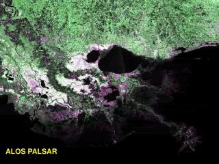
PALSAR for Cycle 20 June 9 to July 25, 2008 Fine Beam Dual-Pol ascending coverage of the blue regions is the plan from the basic observation strategy for Cycle 20 this summer
User Driven Observations • User driven requests have the highest success rate when in line with the strategy for a cycle • For example, it is difficult to successfully acquire quad-pol data during cycles that are focused on acquiring dual-pol data • ASF plans user requests two weeks in advance of the observation week • Requests are submitted to JAXA on a weekly basis • Requests are necessary for acquisitions (direct downlinks to ASF)
PALSAR Observation Scheduling Success
Data Search and Order • AADN – Americas ALOS Data Node • Automatically receives all scenes acquired over North, South and Central America since ALOS went operational from JAXA and makes them visible through the AADN URSA • URSA – User Remote Sensing Access interface • ASF search and order interface • Two versions exist, one for searching the DAAC catalog, the other for searching the AADN catalog • AUIG – JAXA’s interface for searching the catalog of all known ALOS observations • Out-of-zone – Scenes that are acquired for any region of the world other than the Americas or prior to the operational phase of ALOS
PALSAR Scenes in the DAAC • Scenes in AADN archive are ordered for transfer to the DAAC when requested by approved users • Out-of-zone scenes are ordered for transcription from JAXA when requested by approved users • All PALSAR scenes in the DAAC archive can be seen and ordered by approved users • All PALSAR scenes that have been processed by the DAAC are available from the PALSAR datapool • Subscriptions can be established by approved users for transfer and processing by the DAAC
Searching for Data • The ASF URSA interface should be used to identify scenes for transfer from the AADN archive • The AUIG interface should be used to identify out-of-zone scenes for transcription and transfer to the DAAC • The DAAC URSA interface should be used for ordering scenes for processing
Out-of-Zone Data • Out-of-zone scenes are scenes that were acquired for areas outside of the Americas or prior to the operational phase of ALOS • Out-of-zone scenes are identified by searching the AUIG • To request an out-of-zone scene, a user needs to send ASF the scene id and date of observation • On average, there are 9 days between placing an out-of-zone order with JAXA and receiving the data for the AADN archive • When requesting out-of-zone data for DAAC projects, USO orders the scenes for transfer as soon as they appear in the AADN catalog
JAXA Archive • Global archive • Guest may search all PALSAR holdings • Commissioning phase data (May 15-Oct 22, 2006) • Scene ID and date required for OOZ order • https://auig.eoc.jaxa.jp/auigs/top/TOP1000Init.do
AADN Archive • https://ursa.aadn.alaska.edu/ • Guests can search all PALSAR holdings in the AADN archive • Data over the Americas acquired since October 23, 2006 • Some global data • Scene IDs are required to designate data for transfer
Data Order • Data credits awarded by proposal approval are only valid for PALSAR data processing • Investigator logs into URSA DAAC and orders scenes for processing to desired parameters • Processed data is automatically entered into the USGRC PALSAR Data Pool in addition to being delivered to investigator
Interfaces • AADN URSA: https://ursa.aadn.alaska.edu/cgi-bin/login/guest/ • DAAC URSA: https://ursa.asfdaac.alaska.edu/cgi-bin/login/ • AUIG: https://auig.eoc.jaxa.jp/auigs/top/TOP1000Init.do
Order Processing • Users may order scenes for processing once they are transferred to DAAC • All PALSAR scenes processed by the DAAC are available through the PALSAR datapool
Subscription Procedure • User defines either the region or paths and frames that are desired • ASF searches for scenes that match at regular intervals and transfers them to the DAAC archive • ASF either notifies the user that the scenes are available to be ordered for processing, or orders the scenes for the user based on parameters such as processing level and delivery method that the user has predefined • Once processed, scenes are available to all approved users through the PALSAR data pool
ASF User Tools USGS Webinar 25 April 2008
Freely available software (BSD license). Developed with an intention to increase the usability of SAR data. Intuitive user interface enables those with little or no SAR experience to readily process it for use with other data layers. MapReady
Ingests ASF, CEOS, and GeoTIFF data formats. Can export the data to JPEG, GeoTIFF, PNG, and some other formats. Geocodes data to any of five popular map projections UTM, Polar Stereographic, Lambert Azimuthal Equal Area, Lambert Conformal Conic, Albers Equal Area Terrain corrects (orthorectifies) to remove artifacts commonly seen in SAR data such as layover and shadow. MapReady
Includes support for multiband data such as polarimetric data. Batch processing ability allows users to process large volumes of data at once. Preview images are visible for each item in the batch list (input and output). Includes a metadata viewing tool. Input and output images can be viewed in full resolution with the integrated ASF View tool. Image footprint can be viewed in Google Earth™. MapReady
Goals for the near future: Support for Single Look Complex data. Improved support for polarimetric data. Ability to ingest and process AirSAR data. Ability to ingest and process data written by the Gamma software. MapReady
Convert to Vector This simple tool allows users to create a shape or kml file based on images that may not be viewable but have metadata. The area’s footprint can then be viewed using Google Earth™ or ArcMap™. Non-lat/lon metadata is passed along as attributes. Windows release planned for May 1st. Pending testing & validation.
ASF Forum • ASF hosts an online forum for users to ask questions of our technical staff and user community. • Over 165 members • Nearly 600 total posts and growing • https://forum.asf.alaska.edu
uso@asf.alaska.edu 907-474-6661