Download
1 / 36

E N D
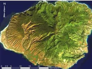
Kauai is the northernmost and geologically the oldest and most complex of the main Hawaiian Islands. It is roughly circular in shape and was formed by a single shield volcano. Kauai is the fourth largest of the Main Hawaiian Islands. Kauai has a mean diameter of 43 kiolmeter (26 miles) and an area of 555 square miles (143,710 ha). The highest peak, Waialeale reaches an elevation of 1540 m (5,052 ft), followed by Kawaikini, at 1600 m (4160 ft). Mountainous terrain occupies the north, west and central part of the island. The gentle east and south slopes are cut by shallow gulches. A narrow, gently sloping coastal plain skirts the island, but is interrupted on the northwest side by a 25 km (16 mile) stretch of precipitous cliffs (Na Pali) which rise from the water's edge, and on the southeast by a the Hoary Head Mountains which rise to elevations of about 748 m (2,280 ft.) above sea level. Adjacent to the coastal plain are the longest stretches of excellent beach to be found in the state. Some of these beaches ( Kapaa, Hanapepe and Kekaha) have undergone severe erosion in recent years
Geology of Kaua‘i • Kaua’i consists of perhaps a single shield volcano formed 5 million years ago. • Like the Ko’olau Volcano on O‘ahu, only has shield stage and rejuvenation stage without the post-caldera alkalic cap • Lacks well-defined rift zones like O‘ahu volcanoes • This volcano has experienced significant faulting and has the largest known caldera of any Hawaiian volcano • This volcano has also passed through the erosion and coral reef growing stages • Erosion also affected by faulting: Waimea Canyon
Kaua‘i Volcano, Shield Stage • Shield-stage rocks are called the Waimea Canyon Volcanic Series • Na Pali Member (5.10 to 4.30 Ma) • shield-forming rocks outside of the caldera • thin, inclined flows • tholeiitic basalt • Olokele and Makaweli Members (4.16-3.6 Ma) • fill the caldera and the Makaweli graben (normal falut-bounded valley), respectively • thick, flat-lying flows • tholeiitic basalt, alkalic basalt, and hawaiite • Haupu Member (unknown age) • lavas filling a small caldera on the southeastern flank of the volcano
Kaua‘i Volcano, Rejuvenation Stage • Called the Koloa Volcanic Series • Age: 2.3 to 1.0 Ma • ~40 vents, spatter and cinder cones, and a tuff cone • Koloa lavas cover about half of the surface of the eastern part of the island • floor the Lihue Basin • Interbedded with the Koloa Volcanic Series is the Palikea Formation, consisting of conglomerates and breccias, coarse sedimentary rocks produced by mass wasting-style erosion
Waimea Canyon is 16 km (10 miles) long, a mile wide and 1,000 meter (3,600 feet) deep, with a completely different climate at the bottom than at the top
Na Pali is one of the most rapidly eroding shorelines in Kauai. As the cliffs erode, the landscape creates fantastic, vaulted valleys and snaking, hidden beaches where the sea hungrily licks at the thousand-foot cliffs.
Na Pali is one of the most rapidly eroding shorelines in the world. It's crumbling. But as it erodes, the landscape creates fantastic, vaulted valleys and snaking, hidden beaches where the sea hungrily licks at the thousand-foot cliffs.
Sedimentary Rocks • Extensive deposits of colluvium (mass wasting deposits) and alluvium (stream erosion deposits) • Cemented sand dunes and beach rock • Sediments can form coastal plains
ancientsea cliff coastalplain
Geologically the oldest of the main eight Hawaiian Islands, the northernmost island of Kaua'i has a total area of 1420 sq km (552 sq mi). This island receives the most rainfall of the main eight Hawaiian Islands, thus giving its nickname of the Garden Isle. Kaua'i is surrounded on all sides by a fringing reef, with a reef flat sometimes as wide as 1 km (0.6 mi). The reef is under the influence of high wave energy due to the island's geographic position.
2006 March 14 Flood: Rushing waters from breached Kaloko Reservoir on Kaua'i gouged out large portions of Wailapa Stream Tuesday before entering Morita Reservoir, at left. Farmers, who depend on water from the reservoir, want it to be preserved, if it can be safely maintained.
Geology of Ni‘ihau • Lies off of main trend of Hawaiian Islands, a “cross trend” • A deeply eroded remnant of a shield volcano fringed by a platform composed of rejuvenation stage volcanic rocks • Well-developed calcareous dune deposits
Ni‘ihau Volcanic Rocks • Shield Stage • Paniau Volcanic Series, 5.5 to 4.8 Ma • tholeiitic and olivine-rich basalts, dikes and lavas • evolving towards alkalic postsheild stage? • caldera and summit are gone, only a rift zone remains • erosion? faulting? • Rejuvenation Stage • Ki‘eki‘e Volcanic Series, 2.2 to -0.3 Ma • 9 vents, including Lehua Island • all are dry eruptions except for 2 tuff cones • produced lavas that cover a wave-cut terrace • alkalic olivine basalt, not as low in silica as rejuvenation stages on other islands
Iniki flooding reached >800 ft inland and >25 ft above sea level