Indoor Mapping
The way we visualize and experience indoor spaces is changing drastically, and it is todayu2019s organizations and establishments that are leading the charge. It wouldnu2019t be a false claim to say that technological innovation is completely revolutionizing our experience of place. When it comes to smart spaces and a new experience of place, the wheels of change are already well and truly in motion, and we are well on our way to creating a more connected world.

Indoor Mapping
E N D
Presentation Transcript
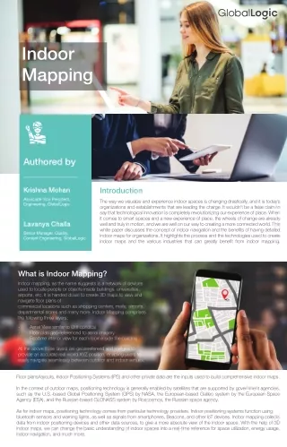
Indoor Mapping Authored by Krishna Mohan Introduction Associate Vice President, Engineering, GlobalLogic The way we visualize and experience indoor spaces is changing drastically, and it is today’s organizations and establishments that are leading the charge. It wouldn't be a false claim to say that technological innovation is completely revolutionizing our experience of place. When it comes to smart spaces and a new experience of place, the wheels of change are already well and truly in motion, and we are well on our way to creating a more connected world. This white paper discusses the concept of indoor navigation and the benefits of having detailed indoor maps for organizations. It highlights the process and the technologies used to create indoor maps and the various industries that can greatly benefit from indoor mapping. Lavanya Challa Senior Manager, Quality, Content Engineering, GlobalLogic What is Indoor Mapping? Indoor mapping, as the name suggests is a network of devices used to locate people or objects inside buildings, universities, airports, etc. It is handed down to create 3D maps to view and navigate floor plans of commercial locations such as shopping centers, malls, airports, departmental stores and many more. Indoor Mapping comprises the following three layers: - - - Aerial View similar to Orthophotos Floor plan geo-referenced to aerial imagery Realtime interior view for each room inside the building All the above three layers are georerefereed and merged to provide an accurate real-world XYZ position, enabling users to easily navigate seamlessly between outdoor and indoor venues. Floor plans/layouts, Indoor Positioning Systems (IPS) and other private data are the inputs used to build comprehensive indoor maps. In the context of outdoor maps, positioning technology is generally enabled by satellites that are supported by government agencies, such as the U.S.-based Global Positioning System (GPS) by NASA, the European-based Galileo system by the European Space Agency (ESA), and the Russian-based GLONASS system by Roscosmos, the Russian space agency. As for indoor maps, positioning technology comes from particular technology providers. Indoor positioning systems function using bluetooth sensors and warning lights, as well as signals from smartphones, Beacons, and other IoT devices. Indoor mapping collects data from indoor positioning devices and other data sources, to give a more absolute view of the indoor space. With the help of 3D indoor maps, we can change the basic understanding of indoor spaces into a real-time reference for space utilization, energy usage, indoor navigation, and much more.
Why Indoor Mapping? There are many companies providing solutions for navigation that work incredibly well, but they are limited to outdoor navigation. As of today, there is no definite solution to indoor navigation. Location navigational services available on our mobile devices stop working as soon as we reach a destination building; they don't navigate through the inside spaces/points of the building. Indoor navigation starts where traditional outdoor navigation stops. With an increasing curiosity and the necessity of indoor exposure inside grocery stores & malls, large office complexes, health care sectors, indoor mapping is the new normal. Step by step navigation guidance screenshot comparison between indoor mapped building Vs non-indoor mapped building Indoor mapped building Step by Step Navigation - Indoor Mapped Venue Non Indoor mapped building Navigation - Non Indoor Mapped Venue Today, all of us use maps to find our way and destinations. Nowadays, smart devices are part of our daily lives in our day-to-day activities and increasingly, we are becoming more dependent on these devices. Although all large buildings do have efficient ways (floor maps pasted on the walls, etc) to guide people across their floors, we still often find it difficult to navigate our way through and end up asking people around for guidance. How many of us have ever felt lost in a hospital or left the supermarket without buying a product as we didn’t locate that product? How many of us have roamed around the office looking for that new meeting room or a colleague’s desk? Most of us have and this is when Indoor mapping comes to the rescue! However, before starting to create an indoor map for a building, we need to consider some of the common constraints. Firstly, large private complexes like malls are managed by venue managers who keep a tight control and security check over who, when and how the general public is allowed to enter the premises and most time, it requires prior approvals to be sought. Buildings like Hospitals and/ or Airports are accessed by the general public, but still there are some restricted sensitive areas where the general public is prohibited to enter. Secondly, buildings keep evolving all the time, requiring constant updates on the maps. The only thing more disappointing than having no map is to have an outdated map. Ideally, since maps are attached to the facility’s central database, renovations or temporary block- ages that are made to the area would be reflected automatically. Finally, routing regulations inside a building are not always permissible. Some efficient ways of possible entries and exits inside the buildings are limited to some authorized personnel only.
How Indoor Navigation Works? Indoor positioning systems (IPS), also referred to as indoor GPS, can let you know exactly where you are inside a building and where to track your destination. By itself, though, it cannot show you how to reach your desired location. Using the locations given by IPS, indoor navigation can provide turn-by-turn directions that will help you to reach the right location. Indoor navigation depends on different technologies compared to GPS, which relies on satellite signals that are easily obstructed by walls and ceilings. To overcome the limitations of GPS sensors, there are few technologies available in the global markets, i.e, WiFi, Bluetooth beacons, and Ultra-Wideband (UWB), etc. So how does IPS help in finding a particular store in the mall? IPS only helps with location of specific places or objects and the other information / details are required to provide a complete indoor navigation system: A complete map of indoor space: Indoor mapping process involves building a complete representation of indoor space through mapping floor plans, indoor positioning information and other data. A user-facing tool: An application that runs on a smartphone or a kiosk inside the facility which navigates the user with the help of a map. This complete system referred to as indoor positioning and indoor navigation has many other uses beyond locating a particular store within a mall. Use Cases for Indoor Navigation Indoor navigation can be widely used in many different verticals. Apart from helping map users navigate through building interiors, indoor maps can also provide useful information to maintenance managers, facilities coordinators, marketing personnel, and merchandise store owners for handling day to day tasks without increasing complexities, get facility information, building maintenance made easy, targeted marketing for store owners etc. Unlike GPS, which relies on satellite transmissions, indoor mapping uses Wi-Fi signals or Bluetooth beacons because satellite signals typically cannot penetrate buildings. As the technology progresses, finding a person, asset, or room inside a building may become as easy as consulting a Wi-Fi-connected handheld device provided with 2D or 3D graphics to guide you to the right place. Indoor mapping technology is expected to find a host of practical uses in larger facilities such as factories, warehouses, hospitals, hotels, shopping malls, sports arenas, and office buildings or in simple words any place where it's easy to get lost. The evolution of Indoor mapping in a smartphone would enable us to get turn-by-turn guidance in any way of commutation with a GPS enabled system. Hospitals Indoor navigation is helpful for visitors and patients in a hospital. Finding their destination is a problem for visitors and patients. Real-time navigation can reduce the effort and time of a user in navigating especially in an emergency situation. It can also help hospital staff in finding the equipment when they need it on time. Indoor navigation with asset tracking feature mitigates all such problems. Even each equipment can be tagged so that the IPS system knows where it is located, and indoor navigation can lead to the destination. Shopping malls and large stores Indoor navigation in shopping malls helps to get real-time directions to a particular store/place. In large buildings, it can lead you to specific products as well. You can also fetch important marketing data from indoor navigation systems. For example, the total time spent by people in each store? Which areas do people frequently use directions for? With this information, you can make popular items or stores to be found easier or even rearrange the store layout based on what people need the most. Using IPS technology, marketing for larger stores is also made easy. Advertising agencies can share their offers with live updates directly to the smartphones, for example, if a user passes through Reliance Digital, he/she can receive the current offers running at the store.
Field Service For field service workers, GPS, geo-positioning, and mapping applications have become increasingly common in recent years. Feasibility of discovering the shortest route to the destination by knowing the current location is a boon by using maps and in a new/unknown infrastructure by the help of Indoor maps. When it comes to field workers, discovering the destinations in a complex building to facilitate the day-to-day activities can be made easy by having a detailed indoor map. Delivery drivers and couriers partners, for instance, would be able to quickly find a place of interest. Whether in a large apartment complex or a huge office building, delivery teams on service calls often spend way too much time trying to find a place. Wielding the ability to pinpoint a customer's / merchant’s exact location within a building could be a very useful feature. University campuses Universities tend to deploy smart campus technologies nowadays. In modern university campuses, network technologies enabled features tend to be more efficient in terms of security and improving the ease of access. Office buildings Indoor navigation converts the office campuses into smart offices, which helps to locate the amenities like conference rooms, restroom, cafeteria and many more. It's easy to find the meeting rooms which are vacant and occupied. It also supports people to locate their assets like printers, tools, or test equipment. Airports Airports with smart technology can gain the confidence of customer experience to a larger extent. For example, with the help of Indoor mapping, airports like John F. Kennedy International Airport has the technology to provide additional features to passengers like airport indoor navigation, live flight info, alerts onboarding, and multi-languages translations of airport signage. It also helps with the baggage claims! Multi-story car parks Larger venues like shopping malls, stadiums and airports with multi-story parking areas, it's a hectic job to find a place to park and then again, to remember and locate where the vehicle is parked. Indoor navigation helps the customers find the correct way and optimize the time. With the help of some IoT technology, drivers can also get information about an open parking space and lead them to it. Benefits of Indoor Mapping Integrated wayfinding Indoor mapping offers a frictionless transition from outside to the inside of a building. It can guide users from their doorstep to the closest parking spot or right to the desired destination within a building. Indoor Mapped Corporate Campuses Corporate campuses are one major sector that largely benefits from indoor mapped buildings. It helps employees become more efficient and productive.
IT team can track the static and moving assets Facilities team can manage space utilization and energy efficiency more efficiently Results in effective booking of meeting rooms, where the employee can decide and book the meeting room which is in close proximity to the intended audience Location-Based Marketing: Indoor maps enable to personalize the experience for shoppers by sending alerts on special offers or discounts, thereby increasing their sales On-Time Delivery: The most common problem for the delivery executives is to find the exact location of the pick-up or drop location. They usually have difficulty finding the right parking space to navigate within large complexes. This leads to delay in making deliveries, and at-times, resulting in a lost customer base due to dissatisfied customers. Hospitals: Medical facility is one service that creates a huge impact if not serviced on time. First-time visitors usually find it very difficult to navigate and find where various departments are located. One Stop Solution :Indoor map serves as a one stop solution not only for way finding problems, it also solves many traditional and complex day to day tasks related to emergency and risk management, leading to high customer satisfaction and retention. Risks if Indoor maps are inaccurate: Customer dissatisfaction can lead to users switching to better maps providers 1 Retail stores would not be able to send customized alerts about the ongoing offers to the targeted customer base who are already in the mall 2 Fleet Management service providers would not be able to share dynamic alerts such as change of flight departure, gate no and / or delay in flight timings 3 Decreased customer base as shoppers often get lost in large buildings. Larger the building, the bigger the problem 4 Inefficient asset tracking can lead to large corporates being completely clueless to visualize and track the static assets and moving assets. Ineffective tracking of immovable assets can be a challenge in industries and high scale operational organizations during the time of disaster management 5 Improper route guidance can have a high chance of putting lives of people at risk and reputation of hospital at stake, especially in time-sensitive situations 6 There is a high chance of delay in reaching the airport and missing the flights, especially in case of emergencies or medical mishaps, due to inadequate and non-availability of navigational resources, resulting in a bad user experience 7 Highly populated SEZs, business parks, malls can have higher risks of loss of lives, in case of any lacunae in the infrastructure understanding during times of natural calamities or mishaps outbreaks 8 Conclusion The location data derived from indoor positioning systems has a great amount of potential to create and accelerate the much-needed solutions in today’s world. This data has the capacity to create intelligent spaces that anticipate users’ needs to make life easier, smoother and more efficient. It opens the door to personalized location-based services in the workplace, while improving collaboration, delivering real operational improvements, and generating new insights. Indoor maps hold an exciting and a promising future in creating digital and smart spaces, while proving as a valuable asset for every section of the society. The future of indoor mapping is here to stay. About the Authors Krishna Mohan Veeravalli (Kris) is an Associate Vice President, Engineering at GlobalLogic. With two decades of experience in software and content engineering, Kris leads a large number of Content engineering specials and is responsible for the successful management and delivery of all critical projects . Kris holds a double masters degree from Institute of Management Technology (IMT), Ghaziabad and Osmania University. Lavanya Challa is a senior manager at GlobalLogic. She has 19 years of experience in GIS, with specialized expertise in process improvements and delivery management. She holds a Masters degree from ISBM and PG Diploma in data analytics from IIIT-B.