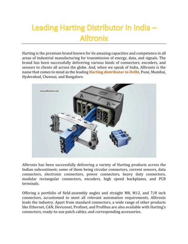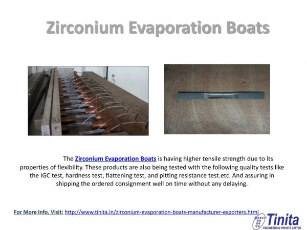
LiDAR-Solutions-for-a-Leading-Australian-Electricity-Distributor
0 likes | 22 Vues
Australia's electricity distribution network is a vast and intricate infrastructure, serving millions of consumers across the continent. To maintain the reliability and efficiency of this critical system, leading Australian electricity distributors are turning to cutting-edge technologies like LiDAR (Light Detection and Ranging). In this article, we will explore how LiDAR solutions are revolutionizing the operations of a prominent electricity distributor in Australia, enhancing their ability to provide safe, reliable, and sustainable power to their customers.<br><br>

LiDAR-Solutions-for-a-Leading-Australian-Electricity-Distributor
E N D
Presentation Transcript
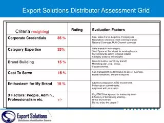
CASE STUDY Techwave Techwave 2004, is a global end-to-end IT services company, which long-term relationship with clients by leveraging unique delivery models and expert frameworks. established in & solutions develops LiDAR Solutions for a Leading Australian Electricity Distributor About Client The client is an Australian Electricity Distribution company that delivers a safe and reliable electricity supply to more than 1.8 million customers across Sydney, the Central Coast, and the Hunter. Their network area covers 22,275 square kilometers and includes more than 200 large electricity substations, 30,000 small distribution substations, 500,000 power poles, and almost 50,000 km of below and above-ground electricity cables. The client has a Bushfire Mitigation Strategy to manage the risk of bushfires caused by its hazards on their electricity network. To support the client’s bushfire strategy, a leading geospatial and asset management service provider and Techwave partnered and provided a turnkey solution, including the survey, inspection, and reporting on overhead assets, related attachments, and surrounding environments on bushfire-prone lands as an audit of those assets for vegetation encroachment and hardware defects in preparation for bushfire danger periods. Executive Overview Techwave has provided LiDAR processing services to the client for their Bushfire Aerial Patrol (LiDAR) 2022 program along with our partner – a geospatial and asset management service provider. Techwave.net info@techwave.net Ph:+1 281 829 4831
Pole top photo review and linking GIS cleaning: Updating of The client’s existing GIS network to cover all the latest changes Segment Review: Classifying the LiDAR data of the network and neighborhood for determining the vegetation and other man-made encroachments Leveraging our core domain expertise in electric utilities, we analyzed laser scan data to gain valuable insights and perform precise encroachment calculations in a three-dimensional environment. To optimize costs and handle large network volumes efficiently, we implemented an offshore model with a focus on quick turnaround times. Current Status As part of a multi-year program, Techwave has undertaken the critical task of analyzing and securing all the client's assets, protecting them from potential hazards. The first year of the program has been successfully completed, during which Techwave efficiently ramped up its workforce with over 120 skilled resources to meet the client's demanding quick turnaround requirements. Our expert team meticulously analyzed various inputs, including LiDAR data, to update the network and identify potential hazards for each span through vegetation analytics. Techwave's approach involved streamlining the process of back-filling primary resources and expediting the onboarding of new resources. By creating structured process documentation for each module, the integration of new resources becomes seamless, enabling them to be productive right from day one. Techwave.net info@techwave.net Ph:+1 281 829 4831
Client’s Challenges Every network operator had to follow the Legislative and Regulatory Framework and the management practices established by Industry Safety Steering Committee (ISSC). Vegetation Hazard Management Cycles: Bushfire Risk Assessment: Vegetation Hazard Remediation: Develop and implement a plan for the regular identification and remediation of Vegetation Grow-In and Fall-In hazards An assessment of the fire risk in the context of the operation of Electricity Assets as determined by The client utilizing data, advice and information provided by relevant sources. Bushfire risk assessments is used to define the various levels of risk within a Bushfire Prone Area to determine treatments and priorities. Develop and implement a system for the routine inspection, identification, and remediation of vegetation hazards Minimum Clearing Requirements Bushfire Danger Period Preparedness Fall-in Vegetation Hazards Hazard Remediation Prioritization Special Circumstances and Exceptions Techwave’s Strategy and Solutions Techwave, in conjunction with our partner team specializing in geospatial and asset management services, designed custom solutions to precisely meet the unique demands of our client. The client's High Bushfire Region network was thoroughly examined using a range of remote sensing techniques, including aerial, mobile, and terrestrial methods. Multiple data sources, such as LiDAR and images, were acquired during the inspection process. Reviewing and attaching pole top images to the GIS data Completion of data analytics requirements by updating the spatial geometry and attribute information of existing and newly found assets and executing vegetation clearance analytics. LiDAR classification of vegetation, span, pole and tile segments, and conductor and crossarm analysis of span and pole segments. All allocated services are completed using AIMS Clearance Segment Review and QGIS software. Techwave.net info@techwave.net Ph:+1 281 829 4831
Business Impact Techwave reached a significant milestone by supporting our prime contractor, a Geospatial and asset management service provider, with efficient and quick turnaround for handling substantial volumes and resource management aligned with project requirements. During peak project execution, we engaged over engineers and delivered substantial within a shortened timeframe. 120 successfully volumes skilled In the first-year program of bushfire aerial patrol, we achieved the delivery of nearly 125,000 spans of electricity distribution and transmission network assets with the utmost quality. Techwave.net info@techwave.net Ph:+1 281 829 4831
Why Choose Techwave? Techwave excels in delivering innovative solutions to complex business challenges. Renowned for its commitment to subject expertise and resource optimization, Techwave has built a strong reputation for providing customers with top-notch services and products. Empowered with the latest technologies and tools, Techwave's team of over 1000 dedicated engineers can provide comprehensive end-to-end assistance to clients. Techwave Australia Pty Ltd. 3 Bowen Crescent, Level 2, Melbourne VIC -3004, Australia. Ph: +61 3 9867 8903 info@techwave.net Techwave.net info@techwave.net Ph:+1 281 829 4831