Download
1 / 31
310 likes | 335 Vues
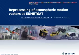
Explore the reprocessing of EUMETSAT's atmospheric motion vectors dataset for climate studies and reanalyses. Learn about Geostationary AMVs, MSG satellites, algorithm advancements, and operational monitoring.

E N D
Reprocessing of atmospheric motion vectors at EUMETSAT M. Doutriaux-Boucher, R. Huckle, A. Lattanzio, J. Schulz
ERA-CLIM(2) European Reanalysis of Global Climate Observations • EUMETSATs contribution, reprocessing of: • AVHRR Atmospheric Motion Vectors ( ) • Radio Occultation bending angles • ASCAT Level 1 data products • Combined GOME-2 & IASI ozone columns • SSM/T2 and AMSU-B/MHS radiance data • METEOSAT Atmospheric Motion Vectors ( ) • Clear and All Sky Radiance • Geostationary radiance data (referenced to IASI) http://www.era-clim.eu/ LEO GEO
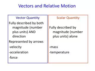
Why do we reprocess satellite data? Long, stable time series Comprendre les phénomènes sur courte échelle Understand short scale phenomena Understand change Accuracy • Detect • change
MSG satellites used for the MPEF reprocessing MSG 1- Meteosat-8 2- Meteosat-9 3- Meteosat-10 04 05 06 07 08 09 10 11 12 13 14 0°
The Geostationary reprocessing system, RMPEF SEVIRI lev1.5 images Archive Ancillary forecast data (ERA interim ECMWF) Products MPEF algorithm (version from 2013)
Atmospheric wind vectors AMV derivation 00:00 00:15 00:30 00:45 v1 v2 v3 vf ? Vector height Intermediate products About 10000 winds are detected. Final product
Operational monitoring,time series of the number of derived AMVs per hour - Operational statistics MET9 became operational Change in height assignment CCC Change in height assignment and quality control
Clear benefit of the reprocessing - Number of operational AMVs - Number of operational AMVs - Number of reprocessed AMVs
Excellent AMVs (80<QI<100) All AMVs High level AMVs CCC Met8/Met9 CCC Met8/Met9 Mid level AMVs Low level AMVs Number of operationally produced AMVs Number of reprocessed AMVs
AMV speed - Monthly averaged, 2006, 11:45UTC High (0-400hPa) 60 Latitude Mid (400-700 hPa) Feb Jun Dec -60 Low (700-1050 hPa)
Time series over the MSG reprocessed period 2004 - 2012 Speed (m/s) Pressure (hPa) Latitude Latitude 2004 2005 2006 2007 2008 2009 2011 2012 2004 2005 2006 2007 2008 2009 2011 2012
...and in a few years from now, the complete series... 60 Meteosat second generation Meteosat fisrt generation Latitude -60 1981 1985 1989 1993 1997 2001 2005 2009 2013 2018 2022
March 2006 – RAOB sonde /MSG (8084 raobs) MSG radiosonde
Processing CIMSS EUMETSAT 3 AVHRR images + Forecast data 2 AVHRR images + Forecast data 100 minutes 200 minutes V-1 V+1 V-1 V+1 V0 V0 T-1 T0 T+1 T-1 T0 V0= V-1 V0= (V-1+ V+1)/2
Processing 3 AVHRR images + Forecast data 2 AVHRR images + Forecast data 100 minutes 200 minutes Remapping of each PDU on the reference image to a non constant grid (online) Remapping of entire image polar stereographic projection on a constant 2x2km grid (pre-processing) Targeting 13x13 target box (2x2 km) Targeting 28x28 target box (1x1 to 4x2 km) Tracking search box 100x100 Tracking search box 48x48 Forecast (first guess) Forecast (first guess) Initial height assignment Done once on mid image (in targeting step) Initial height assignment Done twice, forward and backwardimage Forecast (IR EBBT) Forecast (IR EBBT) Final height Adjusted to best fit NWP data Final height CCC Method Forecast (Best fit)
Spatial distribution of AMVs EUMETSAT AVHRR CIMSS AVHRR
Spatial distribution of AMVs EUMETSAT MSG Overlap EUMETSAT MSG – AVHRR
AVHRR AMVs time series – speed (2007 - 2012) North Pole Number of AMVs Avg. Speed North Pole South Pole Avg. Speed South Pole
AVHRR AMVs time series – pressure (2007 - 2012) North Pole Number of AMVs South Pole Avg. pressure North Avg. pressure South
EUMETSAT - CIMSS – collocation (speed) – Jan 2008 NORTH POLE SOUTH POLE
EUMETSAT and CIMSS collocated AMVs for July 2010 PRESSURE SPEED NORTH POLE EUMETSAT CIMSS SPEED PRESSURE Over land in winter SOUTH POLE
EUMETSAT - CIMSS gridded statistics (1) Collocations Speed differenceEUM - CIMSS
AVHRR AMV speed against radiosonde (2007 – 2012) CIMSS EUMETSAT Number of AMVs Avg. Speed North Pole Avg. Speed South Pole Collocation criteria: distance: <100km; time <100 minutes
Comparison against radiosonde EUMETSAT May 2008 CIMSS
Summary of EUMETSAT MSG-SEVIRI wind reprocessing • MSG winds have been reprocessed at EUMETSAT with the latest available algorithm (2004-2012). • MSG reprocessing leads to a stable and homogeneous dataset. The dataset is useful and can be used for climate studies, reanalyses, ... • The reprocessing is planned to be extended backward for Meteosat first generation (as soon as the algorithm to process the first generation satellite with a CCC-like algorithm exists at EUMETSAT). • The reprocessing could potentially be repeated using other algorithms.
Summary – METOP-AVHRR (2007 – 2012) • EUMETSAT data set: • Covers the jet region • Overlap with geostationary satellites • higher wind speeds • CIMSS data set: • smaller regional coverage • better agreement with radio sonde and NWP data • Height adjusted to best fit with NWP background • No large geographical differences • No trend over the years • Extend data sets to 2013 • Use latest EUMETSAT algorithm for entire period