Comprehensive Guide to Contaminant Iso Maps and Risk Assessment for Groundwater Studies
This guide provides essential strategies for effectively presenting contaminant iso map data, illustrating groundwater sampling results, and conducting thorough risk assessments. It discusses the importance of organized data tables, the delineation of contaminant plumes, and sampling methodologies. Key recommendations include gauging wells consistently, historical data integration, and careful evaluation of screening levels. The document aims to streamline the risk assessment process for DEQ officials while ensuring compliance with safety standards and regulatory requirements.

Comprehensive Guide to Contaminant Iso Maps and Risk Assessment for Groundwater Studies
E N D
Presentation Transcript
Data Tables • Well presented data tables communicate a lot of information at a glance • Easier to draw conclusions when well organized and presented • Having to scour reports to mine out data to draw conclusions is time consuming • DEQ may not get an accurate picture or understanding • May not reach the same conclusion • Often results in comment letters • Line charts illustrating concentrations over time • Show each contaminant • PCE, TCE, DCE, VC
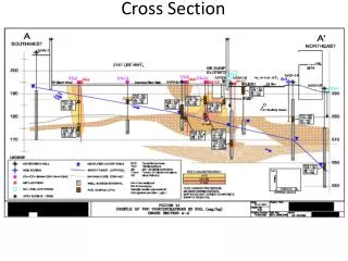
SCR Tips • Delineate plume at least to the MCL /screening level (i.e. show 5.0 ug/L isocon for PCE) but delineating to the detection limits is preferred. • If plume is migrating off-site, then collect off-site samples if possible. At a minimum collect samples from each media at downgradient site boundary • Delineate each constituent of concern. • Gauge wells prior to each sampling event. • Gauge and sample all wells on the same day or as close as possible. • Take surface soil samples • Sample the source not beside it • Put revision dates on figures • Put date of sampling events on delineation figures • Act upon DEQ comments as soon as possible to keep process moving • Analyze broad suite of compounds initially before ruling out constituents
SCR Tips • Multiple rounds of sampling to account for variability and to assess plume stability • Initial GW sampling can be from direct push (geoprobes), however permanent monitoring wells are preferred to provide comparable time-series data at same location • Incorporate data from historical reports into the text, tables and figures of SCR • Do not forget about historic petroleum releases. Sample for VOCs, SVOCs, TAL metals, PCBs (if applicable) • Aquifer tests to obtain site specific flow velocity • Discuss fate and transport, plume stability • Describe/document field procedures and protocols • Collect sub-slab samples (soil, soil-gas) at dry cleaners (VOC) sites
VRP ChecklistRisk Assessment, RAWP, & Certificate Presented by: Patricia McMurray – Risk Assessment Program Manager Sonal Iyer – Risk Assessor Kyle Newman – Risk Assessor Chris Evans – VRP Project Officer William Lindsay – VRP Project Officer
RAP Staff • Pat McMurray patricia.mcmurray@deq.virginia.gov • Kyle Newman kyle.newman@deq.virginia.gov • Sonal Iyer sonal.iyer@deq.virginia.gov
RISK ASSESSMENT PROCESS PROBLEM FORMULATION DATA COLLECTION AND EVALUATION EXPOSURE ASSESSMENT TOXICITY ASSESSMENT RISK CHARACTERIZATION RISK MANAGEMENT Modified from Risk Assessment Guidance for Superfund (EPA 1989)
Risk Goals • Carcinogens • Probability of developing cancer • 1 x 10⁻⁶ to 1 x 10⁻⁴ acceptable risk • Non-Carcinogens • Hazard quotient= site exposure/acceptable exposure • Hazard index=sum of hazard quotients • Hazard index of 1 or below is acceptable
VRP Risk Assessment Guidance • Streamlines the review process • Insures that DEQ has the info we need • www.deq.virginia.gov/vrprisk
VRP Checklist - Data Evaluation • Methods used able to detect compounds at screening levels? • Are all detected chemicals included in screening? • Screening performed for current and potential on-site receptors? • Results compared to background? (optional) • Potential for off-site risks screened?
Data Evaluation Screening • Tier 1-Background • Tier 2-Unrestricted • Tier 3-Restricted
Risk Characterization • Carcinogens • Slope factor or Unit Risk x Exposure • 1 x 10⁻⁶ to 1 x 10⁻⁴ acceptable risk • Non-Carcinogens • Hazard quotient= site exposure/reference dose • Hazard index=sum of hazard quotients • Hazard index of 1 or below is acceptable
VRP Checklist - Risk Characterization • Risk and hazard results presented for all COPCs for all exposure pathways? • Have total risk and hazard results been presented for all COPCs for each receptor? • Are target organ-specific hazards indices calculated if the HI exceeds 1? • Uncertainty assessment included?
Risk Characterization • Tables 5.1-5.14 • Risks and hazards for each receptor by media • Calculation Tools • Example gwcalcs • Tables 5.15-5.22 • Total risks and hazards for each receptor
Risk Characterization Uncertainty Assessment • Data Collection and Evaluation # and type of samples • Exposure Assessment max or UCL, exposure factors • Toxicity Assessment values that are under review
Risk Characterization Reality Check
Vapor Intrusion Review • Data Collection and Evaluation • Groundwater-Table 2.10 • Deep Soil Gas-Table 2.11 • Subslab-Table 2.12 • Indoor air-maybe • Screen for both on and off site
Vapor Intrusion Review • Exposure Assessment • On and Off Site-Table 3.1 a and 3.1b • Current and Future
Vapor Intrusion Review • Lines of Evidence • Horizontal and vertical extent of contamination • Comparison of groundwater, subslab, and soil gas • Seasonal variation and trends over time • Groundwater flow direction and velocity • Downgradient Land Use • Distance to receptors • Preferential pathways • Comparison of source to downgradient concentrations
VRP Checklist - Remediation Levels • Remediation levels calculated when remediation is required? • Tables 6.1-6.4
Remedial Action Work Plans • How will the proposed remedial action accomplish goals • VRP provides flexibility with timing of remedial activities • Can proceed with remedial action without DEQ approval • DEQ will generally be interested in maximum source removal • Follow up later to inform us what was done • Photos, lab analyses, trucking manifests, etc are helpful • If only Institutional Controls are suggested, dedicate a section in the Risk Assessment to describing them and how they will be protective • Note that residential use restrictions also prohibit children’s day care, schools and playgrounds (hotels and motels are OK) • However, prepare a separate RAWP if actual remediation if planned • Provide rationale for remedial strategies considered but not used • Include specific, surveyed no-dig locations
Remedial Action Work Plans cont. • If using chemical injections adequately discuss • Was the correct stuff used • Was it used properly • Was enough used • Will it last long enough to accomplish cleanup goals • What results should we expect • Frequency of confirmatory sampling and for which constituents • Provide adequate reasoning when relying on natural attenuation • Drawing and specs for remediation systems are helpful • SVE, SSDS, etc • Any required O&M Plans (e.g. SSDS), and/or HASPs etc. must be submitted at this point
Demonstration of Completion9 VAC 20-160-70.A.4.a-b. • DOC is a separate document/report submitted after the remediation (per the approved Remedial Action Plan) is complete • Must include a detailed summary of the performance of the remediation. Summary should also include actions taken to investigate the release. Land-use controls are considered remediation • Must include (if applicable) confirmational sampling results demonstrating that…established remedial objectives have been achieved, or that other criteria for completion of remediation have been satisfied (e.g. post-excavation soil samples or post-remediation groundwater samples showing achievement of remediation levels and plume stability, measurements confirming the radius of influence of SSDS etc.) • Must include the total cost of remediation so that the registration fee paid upfront can be reconciled. Any additional balance owed by the participant must be paid at this point (prior to issuance of the Certificate). If a refund is owed to the participant, it will be process at the time of Certificate issuance • The participant must certify compliance with applicable regulations pertaining to VRP activities (this includes items such as waste management and disposal, erosion and sedimentation control, air emissions controls, wetlands, permits, underground injection control ‘rule authorization’ from EPA, etc.)
Public Notice 9 VAC 20-160-120 • Participants must give notice of the proposed or completed voluntary remediation • Notice is made after DEQ concurs with the SCR and the proposed remediation, but prior to issuing the Certificate. • Performed and paid for by the participant, not DEQ. DEQ is not the point of contact listed on the Public Notice. • Written notice is provided to the local gov’t, all adjacent property owners (including VDOT if applicable), and published once in a local newspaper • We recommend also notifying any party with property interests that are affected by the use restrictions. (e.g. utility easements, mortgage holders) • ‘Adjacent’ is interpreted by DEQ to include properties across a roadway from the site • A 30-day comment period follows issuance of the notice • Contents of the notice must include: name and address of the participant, location of the voluntary remediation, brief description of the remediation, general nature of the release, any proposed land-use controls, address and telephone number of a specific contact person to obtain information (not DEQ), and a brief description of how to submit comments
Public Notice - 9 VAC 20-160-120 • Provide to DEQ: a signed statement from the participant that a written notice was sent to all adjacent property owners, and the local government; a copy of the notice, and a list of all names and addresses to whom the notice was sent • Participant shall send all commenters a letter acknowledging receipt of comments • Provide to DEQ: copies of all written comments received, copies of acknowledgment letters, a discussion of how comments were considered, copy of response to comments, a discussion of their impact on the proposed or completed remediation • Documentation should be assembled and submitted in one package after the comment period is complete, usually (but not necessarily) as part of the Demonstration of Completion
Certification of Satisfactory Completion of Remediation • 9 VAC 20-160-110 • The Certificate grants immunity to the participant, owner and future owners of the site from enforcement actions under state law • Immunity is limited to conditions documented at the time of issuance. Certificate can be revoked if new information arises indicating a risk to human health or the environment • Certificate is issued after the participant has demonstrated: that migration of the contamination has been stabilized, that the site has met remediation levels and will continue to meet remediation levels in the future for both on site and off site receptors, and the department concurs with all work submitted pursuant to the VRP regulation
Certificate • Much of the information in the Certificate must come from the participant, which is why DEQ requests the participant create the initial draft of the Certificate. It is a collaborative effort • Guidance and a Model Certificate (available on VRP website) have been developed to facilitate drafting of the Certificate • The Model Certificate represents the standard format and language, approved by the Virginia Attorney General’s Office, to be followed for all sites. No deviations from the model should be expected • If unique circumstances exist requiring a deviation from the standard language, then it will need to be reviewed and approved by DEQ legal staff. There is no guarantee it will be acceptable
Certificate • Be sure to include a surveyed plat and metes and bounds description of the site with the draft Certificate • If land use restrictions are specified in the Certificate, they must be included in a Declaration of Restrictive Covenants (Declaration) and attached to the Certificate. • The Declaration is a legally binding document that must be recorded with the deed of a site to restrict use of the site • The current landowner and all future landowners of the site will be obligated to comply with the restrictions • Any party with property interests that are affected by the land use restrictions must be listed on the Certificate under ‘Encumbrances’, and also sign the Declaration. Examples could include mortgage holders, utility right-of-ways.
Certificate • Draft Certificate is also reviewed by the Risk Assessment Program as a QA/QC step before issuance • After the Certificate is issued by DEQ, it must be signed by the participant and landowner (also trustee, utility, etc., if applicable) and recorded (if use restrictions) w/i 90 days. • A certified copy of the Certificate as signed and recorded must be submitted to DEQ • Take away – Issuance of the Certificate by DEQ does not occur “automatically” after the Demonstration of Completion and Public Notice have been submitted. It is a collaborative effort between the participant and DEQ. It is a legal document, with fixed language, and a lot of details that all must be accurate.