Download
1 / 46
460 likes | 598 Vues
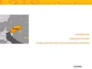
INTRODUCTION. LANDSCAPE POLICIES. THEMES AND INDICATORS FOR AN INTEGRATED APPROACH.

E N D
INTRODUCTION LANDSCAPE POLICIES THEMES AND INDICATORS FOR AN INTEGRATED APPROACH
The Nature Preservation Law regulates landscape planning in the Region of Istria. This law, in place since 2003, provides general indications for the conservation of all natural categories, detailed descriptions for each type of natural area, rules for the conservation of natural eco-systems and sanctioning regulations. The expected effects of this law include the reinforcement of the role of the State in the organisation and supervision of the planning system, new rules for supporting biodiversity and the formation of guidelines for the analysis of the sustainability of man-made interventions in protected natural areas. Notwithstanding the fact that its has been created based on the indications of the European Landscape Convention, the law has perhaps been too amplified, with the result that it is technically difficult to understand for those outside the fields of legislation or other specialists. The Spatial Planning Law is amongst the laws that, in fact, produce significant effects on the governing of the landscape. The State legislation, in place since 1994, is a fundamental part of landscape planning in the Region of Istria; it organises the planning procedures through a set of general guidelines. The law appears obsolete from a procedural point of view and does not sufficiently define the elements of connection with other instruments. Furthermore, the law still appears remote from the principles of the European Landscape Convention, given that it does not yet consider landscape planning as a separate corpus. There are three levels of government in the Region of Istria, corresponding to the State, the regions and the municipalities. At the State level, the Ministry for Environmental Protection and Spatial Planning, amongst its other specific roles, proposes the plans for protected natural areas and National strategies for improving the management and protection of the landscape. The Department for Spatial Planning, Civil Engineering and Environmental Protection, Regional Public Institution for Protected Natural Areas "Natura Histrica", is the competent organism at the regional level. The Department does not have specific legislative responsibilities, but proposes plans for protected natural areas and issues licences for activities in the territories under their jurisdiction. At the municipal level there are 10 Cities and 29 Communities, each of whom is responsible only for that which concerns urban planning, outside of protected areas. The reference instrument for landscape planning in Istria is the Spatial Plan for the Region of Istria (SPRI). The Spatial Plan, in place since 2002, is a plan with instructional powers. In agreement with Croatian Law, the Plan defines the general structure of development and the relationships with bordering regions. It defines the regulations for local planning and guidelines for the valorisation and protection of the landscape (in both written and graphic documentation), defining the management structure within protected natural areas. The Spatial Plan identifies the values of the landscape and introduces monitoring systems for the control of natural areas and for the forecasting of risks that may compromise natural qualities.
CARTOGRAPHY AERIAL PHOTOGRAPHS THEMATIC CARTOGRAFY HISTORICAL CARTOGRAPHY INVENTORIES THEMES AND INDICATORS FOR AN INTEGRATED APPROACH
THE RULES SYSTEM FOR THE LANDSCAPE MANAGEMENT SUBJECT AND ADMINISTRATIVE BODIES LANDSCAPE PLANNING AND DESIGN INSTRUMENTS AND RELATIVE PERFORMANCES LANDSCAPE POLICIES RELATIONSHIPS (IF ANY) WITH URBAN PLANNING INSTRUMENTS LANDSCAPE POLICIES RELATIONSHIPS (IF ANY) WITH THE PUBLIC WORK SECTOR RELATIONSHIPS WITH OTHER POLICIES LANDSCAPE PROJECTS ECONOMICAL/FINANCIAL RESOURCES AVAILABLE GENERAL COMMENTS ON LANDSCAPE POLICIES LANDSCAPE POLICIES
INDICE DELLE PRINCIPALI CARTOGRAFIE DISPONIBILI SCALE 1:100.000 – AVAILABLE SCALE 1:50.000 – AVAILABLE SCALE 1:25.000 – AVAILABLE SCALE 1:10.000 - NOT AVAILABLE SCALE 1:5.000 – AVAILABLE BACK
sources: State Cadastrian Directorate, Region of Istra surface area of territory covered: hole Region availability of databanks: available by payment availability in digital format: Yes degree of accessibility (high, average, low): high BACK
FOTO AEREE DISPONIBILI PRESSO LA REGIONE MARCHE PHOTOGRAPHIC MAPS AERIAL PHOTOGRAPHS BACK
PHOTOGRAPHIC MAPS sources: State Cadastrian Directorate, Region of Istra surface area of territorycovered: hole Region availability of databanks: available by payment availability in digital format: Yes degree of accessibility (high, average, low): high BACK
AERIAL PHOTOGRAPHS sources: State Cadastrian Directorate, private companies surface area of territory covered: almost hole Region availability of databanks: available by payment availability in digital format: Yes degree of accessibility (high, average, low): average BACK
THEMATIC CARTOGRAPHY LAND USE MAP GEOLOGICAL AND GEOMORPHOLOGICAL MAP MAP OF HYDROGRAPHICAL BASINS PARKS MAP BACK
LAND USE MAP • sources: Region of Istra • surface area of territory covered: hole Region • availability of databanks: available by request (without payment) • availability in digital format: Yes • degree of accessibility (high, average, low): high BACK
GEOLOGICAL AND GEOMORPHOLOGICAL MAP • sources: Geological Institute of Croatia (Zagreb), Region of Istra • surface area of territory covered: hole Region • availability of databanks: available by payment • availability in digital format: Yes • degree of accessibility (high, average, low): high BACK
MAP OF HYDROGRAPHICAL BASINS • sources: Hrvatske Vode (State Company), Region of Istra • surface area of territory covered: hole Region • availability of databanks: available by payment • availability in digital format: Yes • degree of accessibility (high, average, low): average BACK
PARKS MAP • sources: decentralized institutions and companies • surface area of territory covered: practicaly hole Region • availability of databanks: low and average (except for some urban areas, like Rovinj, Poreč and Pula) • availability in digital format: 50% • degree of accessibility (high, average, low): low and average (average for technological networks, protected areas map, road map BACK
HISTORICAL CARTOGRAPHY CADASTRIAN MAPS (AUSTRO-HUNGARIAN) - 1820., 1855., 1872., 1911 BACK
CADASTRIAN MAPS (AUSTRO-HUNGARIAN) - 1820., 1855., 1872., 1911 • sources: State Cadastrian Directorate, Region of Istra • surface area of territory covered: hole Region • availability of databanks: available by payment • availability in digital format: Yes • degree of accessibility (high, average, low): high BACK
INVENTORIES CENSUS OF NATURE HERITAGE CENSUS OF ARCHITECTURAL HERITAGE CENSUS OF ARCHAEOLOGICAL HERITAGE BACK
CENSUS OF NATURE HERITAGE • sources: Region of Istra, ("Natura Histrica") • surface area of territory covered: cca 10% of territory • availability of databanks: available by request • availability in digital format: partialy • degree of accessibility (high, average, low): average BACK
CENSUS OF ARCHITECTURAL HERITAGE • sources: Ministry of Culture - Department of Pula • surface area of territory covered: more then 5% of Region • availability of databanks: partialy available • availability in digital format: partialy • degree of accessibility (high, average, low): low BACK
CENSUS OF ARCHAEOLOGICAL HERITAGE • sources: Ministry of Culture - Department of Pula, Archeological Museum of Istra • surface area of territory covered: more then 10% of Region • availability of databanks: partialy available • availability in digital format: partialy • degree of accessibility (high, average, low): low BACK
THE RULES SYSTEM FOR THE LANDSCAPE MANAGEMENT NATURE PRESERVATION LAW SPATIAL PLANNING LOW BACK
NATURE PRESERVATION LAW • name:"Nature Preservation Law" (State Law) • date of approval: 2003., (Official Bulletin № 162/03) • territory of pertinence: hole R. of Croatia • type of law (rules, guidelines…): rules, guidelines, penalties • principal characteristics: general guidelines for nature preservation (all categories), detailed descriptions for different typs of nature areas, rules for organization of the system of nature preservation, penalty rules • expected effect: enhancement of rule of the State in organization nad supervision of the system, new rules to upgrade biodiversity, new rules to upgrade genetic purity, guidelines for acceptable anthropic interventions in protected natural areas • comments: too large and technicaly non-understandible out of the circle of lowyers and specialists in nature preservation, the possibility of impact between local and regional interests is not avoid. Partialy, this Law is accorded to European Landscape Convention; the previous Law, approved in 1994., was technicaly more simple, but it effect same problems in implementation BACK
SPATIAL PLANNING LOW • name: "Spatial Planning Low" (State Law) • date of approval: 1994; updated in 1998., 2000. and 2002. (Official Bulletin № 30/94, 68/98, 61/00 and 32/02) • territory of pertinence: hole R.of Croatia • type of law (rules, guidelines…): rules, guidelines, penalties • principal aspects (important for landscape planning): general guidelines for organization of planning procedures • expected effect : uniformity in organization, procedures and contents of spatial plans • comments : the Law is obsolete in functional procedures , low autonomy of regional and local authorities is still present, the Law is too much undefined in dynamic aspects of implementation; an new concept of Law was proposed (but not approved) in 2003. The general problem is that both Laws (the existing and the new concept) are not accorded with European Landscape Convention - the landscape planning, as an corpus separatum is not even defined BACK
SUBJECT AND ADMINISTRATIVE BODIES NATIONAL REGION PROVINCE MUNICIPALITY BACK
NATIONAL • subject: National (Ministry and/or responsible institution) • name of institution: Ministry for Environmental Protection and Spatial Planning • specific competence • law and rules activity in the field of landscape planning and management • proposal of all regulatory acts (laws, regulations, decisions etc.) when the approval of Government or the Parliament is needed, • landscape planning activity • proposal of spatial plans for protected natural areas (national parks and parks of nature), • landscape planning instruments approval • mandatory agreement for all spatial plans or decision at the regional level concerning protected natural areas • licences activity • licences for spatial planning, licences for commercial and research activities in protected natural areas (national parks and parks of nature), licenses for projects & building on objects of cultural heritage • control activity on institution proposed for the landscape management • supervision on the management authorities of the protected natural areas • implementation and managing of landscape planning instruments • proposal of national strategies to improve the landscape protection and management • research activity • financing of targeted research activities (for spatial planning) BACK
REGION • subject: Region (involved departments) • name of institution: Department for Spatial Planning, Civil Engineering and Environmental Protection, Regional Public Institution for Protected Nature Areas "Natura Histrica" • specific competence • law and rules activity in the field of landscape planning and management • None • landscape planning activity • proposal of spatial plans for protected natural areas (except for national parks and parks of nature) • landscape planning instruments approval • all decisions in competence of the Regional Government and Assembly (especially acts of protection for specific natural areas) • licences activity • licences for commercial activities in protected natural areas (except for national parks and parks of nature) • control activity on institution proposed for the landscape management • both institutions are controlled by the Regional Government • implementation and managing of landscape planning instruments • all decisions in competence of the Regional Government and Assembly (especially acts of protection for specific natural areas) • research activity • financing of targeted research activities (for spatial planning) BACK
PROVINCE • subject: The Province (involved departments) • This subject is unexisting in Croatian constitution BACK
MUNICIPALITY • subject: Municipality (Municipality and/or involved departments) • name of institution: Cities and Comunities (10 Cities and 29 Comunities in Region of Istra) • specific competence • only spatial planning, but not for specific protected areas BACK
LANDSCAPE PLANNING AND DESIGN INSTRUMENTS AND RELATIVE PERFORMANCES SPATIAL PLAN OF REGION OF ISTRA BACK
SPATIAL PLAN OF REGION OF ISTRA • name: Spatial Plan of Region of Istra (S.P.R.I.) • date of promulgation: 2002. (Off.Bulletin of Region of Istra № 2/02) • application ambit (state, regional, provincial, communal): regional • Typology • strategic plan • planning instrument with statutory force • planning instrument with guidance force • informal plan • rules • principal characteristics*: • according to the Croatian Law, S.P.R.I. define the general development • structure of the region, the connection with the national and outborder regions, guidelines and rules for local spatial plans, general guidelines for landscape valorization and protection (textualy and graphicaly) and establish an general frame for development in natural areas • expected effects* : identification of special landscape values and areas; introducement of monitoring systems for natural areas and areas with high risk of deterioration of natural qualities (soil erosion zones, suburban zones, natural grasslands, coastal zone) • comments* : S.P.R.I. is not an document that could be named as "landscape plan", landscape planning is, infact, highly integrated in "protection of nature and special environmental values" • Performances • landscape inventory and database_Yes (generaly) • unity landscape assessment and identification of the specific characteristics_Yes (generaly) • ambit landscape assessment and identification of the specific characteristics_No • landscapes resources value assessment_No • landscape unity/ambit vulnerability identification_Partialy • mutation risk prediction and management_Partialy • landscape protection and management measures_Partialy • establishment of procedures for the participation of the local institutions_No • establishment of procedures for the participation of the local community_No • landscape quality objective identification_No • establishment of protection, sustainable development and rehabilitation projects_Partialy (proposal of spatial plans for protected natural areas) BACK
LANDSCAPE POLICIES RELATIONSHIPS (IF ANY) WITH URBAN PLANNING INSTRUMENTS SPATIAL PLAN OF REGION OF ISTRA BACK
SPATIAL PLAN OF REGION OF ISTRA • name (specify the landscape policy): S.P.R.I. • super • Complimentary to/integrated with • No relation • comments (specify the relationship nature): limitations for enlargements of urban areas; taking in consideration that Istra is an region with very large number of settlements (more then 2.500 settlements on 2.822 km2), but only the coastal ones are tending to enlarge unpropotionaly, S.P.R.I. has imposted measures to reduce the speed of growing of urban areas along the coast. BACK
LANDSCAPE POLICIES RELATIONSHIPS (IF ANY) WITH THE PUBLIC WORK SECTOR NO SPECIAL POLICY BACK
NO SPECIAL POLICY • Name: • super • Complimentary to/integrated with • No relation • comments (specify the relationship nature): There is no special act of Regional Government or Assembly that establish relation between lanscape policies and public work sector; the S.P.R.I. give just an general framework about espected quality of public works in important natural areas, direct measures could be imposed only by Environmental Impact Study (E.I.S.) BACK
RELATIONSHIPS WITH OTHER POLICIES RELATIONS WITH ENVIRONMENTAL POLICIES (PARKS, ECOLOGY, FORESTRY DEPARTMENTS) RELATIONS WITH CULTURAL POLICIES RELATIONS WITH TOURIST POLICIES RELATIONS WITH RURAL POLICIES RELATIONS WITH OTHER POLICIES BACK
RELATIONS WITH ENVIRONMENTAL POLICIES (PARKS, ECOLOGY, FORESTRY DEPARTMENTS) • Type and nature of relationship: Environmental Impact Study (E.I.S.) is the focal point of relation between different environmental policies. The E.I.S. should be made for each physical intervention described in special Ministry act: Regulation about Assessment of Environmental Impact (Official Bulletin N° 59/00) or in S.P.R.I. BACK
RELATIONS WITH CULTURAL POLICIES • Type and nature of relationship: Cultural Heritage Protection Law (Official Bulletin N° 69/99, 151/03, 157/03) This Law contain some rules about "cultivated" landscape; these rules are materialized through the S.P.R.I., especially in definition of character of the "Istrian rural landscape", and some rules about avoidment of potencial impact on the conservated values of rural landscape BACK
RELATIONS WITH TOURIST POLICIES • Type and nature of relationship: Actually, none • No special policy act establish the relation between landscape and tourism; however, the Region of Istra is finishing her "Master Plan of Tourist Development" (M.P.T.D.), that contain guidelines for future touristic development concerning values specific for each "development cluster". BACK
RELATIONS WITH RURAL POLICIES Type and nature of relationship: Several Region of Istra has approved many general and partial acts that have influence on the landscape; the most important are those that regulating the subvention for olive and wineyard grow-up, but also those that regulating suventions and credits for agro-tourism. The Region of Istra in 1996. lounched an Decision about Approvement of Principals of European Rural Development Strategy; those principals are integrated in S.P.R.I. In 2002., the Regional Assembly has constitute the "Istrian Agency for Rural Development", that is not yet prepared to act in large scale. BACK
LANDSCAPE PROJECTS SPATIAL PLAN FOR PROTECTED NATURAL AREAS BACK
ECONOMICAL/FINANCIAL RESOURCES AVAILABLE ORDINARY EXTRAORDINARY OTHER BACK
ORDINARY Regional Budget (ordinary, between 300-350.000 EUR each year, for spatial planning and for management) BACK
EXTRAORDINARY Ministry financial sources (occasionaly, not more than 10-15.000 EUR each year, finances for State institutions in landscape management are not included) touristic Assotiation sources (for several projects, as a "Bike Lanes in Istra","Coastal cleanup", etc., this model of co-financement could be very generous) BACK
OTHER Foundations for nature preservation (symbolic, 20-30.000 EUR each year, generaly for non-government organizations) BACK
GENERAL COMMENTS ON LANDSCAPE POLICIES judgement on the efficacy of the landscape planning and management system in controlling the principal transformation processes of territory* the efficacy of the landscape planning is very low, thanks to its undefined status ; the praxis of spatial planning confirm that between the Concept fase (when, ordinary, the values of landscape are well analized) and the Final fase (when, also ordinary, the competition of development lobbies induce the erosion of the primary concept values) the great part of work remain remain "under cover" and non-transparent; the accessibility to important databases is too different; there is no approved methodology to establish an rational and transparent vulnerability model, that could exclude lateral, non-valorized influence of different lobbists; there is no approved methodology to report changements in landscape, and also not enough qualified institution and professionals to realize it; generaly, the most of administrative authorities still dont understand that the landscape have an limited possibility to be changed without serious dammages weak and strong points* weak points are generaly described in text above; strong point could be the transparancy of the public debate for spatial plans (highly regulated), good organization and influence of non-government organization and public medi principal subject of debate in the region* the principal subject of debate in the region is the transformation of agricultural and forestry complex (especially in coastal zones) in building areas; the public oppinion generaly follow the pression of media, and remain at N.I.M.B.Y. level - emotions are largely more important then rational aspects; the next important subject is the harmonization of state andregional (or local) interests potential reforms currently in progress* Unfortunately, nothing at horizont BACK


![get✔️[PDF] Download⚡️ Disaster Resilience: An Integrated Approach](https://cdn7.slideserve.com/13207044/disaster-resilience-an-integrated-approach-dt.jpg)