Human Settlements
Human Settlements. Human Settlements. Cities – Urban areas Large populations Mix of residential, business and entertainment Suburbia Concentrated populations Highly residential Rural Small populations Often agriculturally based. Current trends in Human Settlement. Urbanization -

Human Settlements
E N D
Presentation Transcript
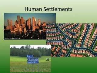
Human Settlements • Cities – • Urban areas • Large populations • Mix of residential, business and entertainment • Suburbia • Concentrated populations • Highly residential • Rural • Small populations • Often agriculturally based
Current trends in Human Settlement Urbanization - • Benefits include • reduced transport costs, • exchange of ideas (quickly) • sharing of natural resources, • large local market • *later amenities such as running water and sewage disposal. • Possible costs would include • higher rate of crime, • higher mortality rates, • higher cost of living, • worse pollution, • traffic and high commuting times. (can we fix this?)
Urban Geography • Urbanization: • Define: the development of towns and cities • Made possible b/c of agriculture development of cities & cities • Importance: Development of cities and increase of populations causes… • Increase in communication • New ideas are created and spread at a faster pace • Increase in trade and production • Allows for specialization of production • EX: not everyone has to farm to produce food, can be merchants, artists, etc. • Cultural diffusion increase
Urban Planning Factors to consider when building a city… • location, location, location - Near key resources (often freshwater, or mineral resources) - Transportation and trade routes (getting to the city) (waterways, mountain passes or valley areas…) - Easily defensive site Ex: hilltops, islands…place where you can seethe enemy coming
Examples Location , defensive position and transportation (into the city) Map of Haarlem, the Netherlands, of around 1550. The city is completely surrounded by a city wall and defensive canal. • West Point
Urban Planning 2. Services the urban population will need - food, supplies, and services(close to production centers or way to transport items into city) - transportation within the city (roads, waterways, public trans.) - governmental organization (buildings reserved for gov’t use – ex: courthouse, capital building)
Serving the City • Ports - locations are selected to optimize access to land and navigable water, for commercial demand, and for shelter from wind and waves By traffic volume Heaviest traveled: 390,000 vehicles per day: I-405 in Los Angeles, California (2006 estimate). Least traveled: 1,800 vehicles per day: I-95 just north of Houlton, Maine to the Canadian border - 2001 estimate Highways – major roads that connect locations.
City Planning Examples • Urban Planning in North America began to be studied and implemented in Ernest during the twentieth century. • WHY? - Cities began to reach critical mass and the need for regulations and coded emerged.
Urban Planning – organizing your city 3. Urban land use - how the city decides to portion off sections of land for a specific use • Many cities designate areas for specific types of buildings (zoning) • Central business district = transportation hubs, with businesses taking up a majority of the buildings • Residential = area designated for housing • Spaces for Public Use • Parks, squares, etc… designed for common use by all city residents. In the late 1800s a number of cities developed public spaces as a way to bring rural environments into a urban setting….
Parks and Recreation • The park initially opened in 1857, on 843 acres of city-owned land. In 1858, Frederick Law Olmsted and Calvert Vaux won a design competition to improve and expand the park with a plan they entitled the Greensward Plan. Construction began the same year and was completed in 1873. • According to Olmsted, the park was "of great importance as the first real Park made in this century—a democratic development of the highest significance…,“ Olmsted believed that the common green space must always be equally accessible to all citizens. This principle is now fundamental to the idea of a "public park", but was not assumed as necessary then. Olmsted's tenure as park commissioner in New York was a long struggle to preserve that idea.
Boston’s North End What are some observation you can make about the roads and buildings in this area?
Colonial Blueprint for Philadelphia1. What are some observations that you can make about the original planning of the city of Philadelphia? 2. Why do you think they planned their city this way?
1. What can we infer about city planning in Boston and Philadelphia from these images? 2. What factors did both Boston and Philadelphia consider when planning their cities? Boston Philadelphia
Modern city planning • Grid – • implemented with the first planned cities. When walled in this design was thought to be good for defense • Widely used in the US • Radial Structure – • many roads ○that force traffic outside of the town
New York City A visionary development proposal, the Commissioners' Plan of 1811, expanded the city street grid to encompass all of Manhattan, and the 1819 opening of the Erie Canal connected the Atlantic port to the vast agricultural markets of the North American interior
City Planning Examples • The 1909 Plan of Chicago was co-authored by Daniel H. Burnham and Edward H. Bennett. Popularly known as the Burnham Plan, it featured waterfront parks and prominent civic buildings, applying the principles of the City Beautiful Movement. Included: • proposals for the lakefront and river • - declared that every citizen should be within walking distance of a park • big infrastructure improvements • The first comprehensive plan for the growth of a large American city and is sometimes referred to as America’s first regional plan. Made possible b/c of the growing tax base of the city
Designing with Beauty in Mind *Avoid excessive human-made clutter *how do you control peripheral growth, housing density and new settlements? *Take into account urban character, local identity and the neccessities
Settlement Hierarchy • Megalopolis/ Megacity- a group of conurbations, • consisting of more than ten million people each. • Conurbation- a group of large cities and their suburbs, • consisting of three to ten million people. • Metropolis– a large city and its suburbs consisting of multiple cities and towns. • The population is usually one to three million. • Large city – a city with a large population and many services. • The population is <1 million people but over 300,000 people. • City– a city would have abundant services, but not as many as a large city. • The population of a city is over 100,000 people up to 300,000. • Large town – a large town has a population of 20,000 to 100,000. • Town– a town has a population of 1,000 to 20,000. • Village– a village generally does not have many services, possibly only a small corner shop or post office. A village has a population of 100 to 1,000. • Hamlet– a hamlet has a tiny population (<100) and very few (if any) services, and few buildings. • Isolated dwelling – an isolated dwelling would only have 1 or 2 buildings or families in it. It would have negligible services, if any.
Settlement Hierarchy • Megalopolis (Megacities) - a group of conurbations, consisting of more than ten million people each. • World Cities: large urban areas that are important nodes in the global economic system. • ie: London, New York, and Tokyo
World Population Distribution Ecumenopolis - the entire area of Earth that is taken up by human settlements. As of the year 2009, the United Nations estimated that for the first time more than 50% of the world's populations lived in cities, so the total population of this area would be about 3,400,000,000 people as of 2010.
Settlement ModelsCentral Place Theory Purpose of Theory: • Explain the number, size and location of human settlements Theory: • Settlements function as ‘central places’ providing services to surrounding areas. • The best arrangement for of different-sized cities serving different functions. Taking the shape of a hexagon • This pattern represents the most efficient arrangement of urban places.
A megacity is usually defined as a metropolitan area with a total population in excess of 10 million people Megacities • Characteristics: • Population dense areas. • Often Suffer from many of the problems of Urbanization. • Resources and services can sometimes be strained due to the high demand from population pressure. (ie: Housing) • Wealth inequality is common poor neighborhoods/ wealthy neighborhoods
Vs. Megaslums… Lagos Questions: • Where is most of the world’s population growth taking place today? • How is population explosion affecting third world countries? • Why are people migrating to Lagos, Nigeria? • With unemployment in Lagos so high how do people make a living? • How are megaslums being created? How are people expanding land to build homes on? http://www.youtube.com/watch?v=LFgb1BdPBZo&feature=related • Characteristics: • Extremely crowded with little to no services/ resources provided to the majority of the population. • Large sections of the population live below the poverty line often in slum conditions • Population density has become problematic & it effects health & safety of citizens
Vs. The City of the Future • Model cities are ranked by a combination of criteria. • urban planning, environmental statistics, energy sources, consumption and emissions, as well as transportation options and habits. • Most lists also make note of green living (such as the availability of public parks, green jobs and sustainable buildings) and green perspective (such as recycling). • challenging for green cities: • - high volume of people, • traffic congestion, • trash and air pollution • Seventy-five percent of the world's energy is consumed by the world's cities http://www.youtube.com/watch?v=DUl6uy6eIDc London – http://www.youtube.com/watch?v=8WiH4R7cqFU&feature=related
Rural & Suburbia Settlements Suburgatory • Defining Characteristics • Dense residential area within commuting distance of the city • History/ development • US Post WWII economic expansion • De-investment in cities (aging cities fall apart) • Increase in home ownership • Greater population density, higher standard of living, complex road systems and franchised stores & restaurants • Examples • Levittown (prototype)
Rural • Defining Characteristics • Low population density, high % of land is agricultural • History/ development • Small farming communities first stage of development for civilization • Since 19th century rural areas declining • b/c – mechanized ag. & more jobs in cities • Land use planning preservation • Examples….
SettlementModelsThe von Thunen Model • Land value is dependent on how far the land is from major cities • Explains economic patterns surrounding cities
Where do Americans Live? • 84 % of Americans live in Suburban and Urban areas • Cities take up only 10% of land; rural areas occupy 90%
An interconnected AgeInterstate Highway System • Why and How did the Interstate Highway System develop in The United States?
Country Planning for an Interconnected Age • Transportation Systems • Roadways (highways/ interstates) • Alternate transportation methods (public transit/ mass transportation systems) • Why are these transportation networks so important? Vs. • Communication Systems • Mail systems • Internet/ phone/ electricity systems • Why are these communication systems so important? • What will your country invest in?