Download
1 / 39
390 likes | 577 Vues
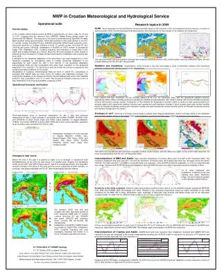
Regional Workshop on Hydrological Forecasting and Real Time Data Management 11 – 13 May 2009, Park Hotel, Dubrovnik, Croatia. Use of Meteorological Forecast Data and Products as Input into Hydrological Models. Jožef Roškar, Enviromental Agency of the Republic of Slovenia

E N D
Regional Workshop on Hydrological Forecasting and Real Time Data Management 11 – 13 May 2009, Park Hotel, Dubrovnik, Croatia Use of MeteorologicalForecast Data and Productsas Input into Hydrological Models Jožef Roškar, Enviromental Agency of the Republic of Slovenia Branka Ivančan-Picek, Meteorological and Hydrological Service of Croatia
Hydrological Model Input = Precipitation (Air temperature, Evapotranspiration etc.) Matematical description of complex hydrological system including characteristics of the watershed, evapotranspiration, infiltration etc. Output = Discharge (Soil Moisture, etc.) Regional Workshop on HFRTDM, Hotel Park, Dubrovnik, 11 - 13 May 2009
Hydrological Forecasting System Observed or estimated rainfall Forecasted rainfall Hydrological Model (deterministic, conceptual, distributed, lump, etc) Forecasted discharge Simulated discharge T = 0 State variables T = 0 Forecast Simulation Regional Workshop on HFRTDM, Hotel Park, Dubrovnik, 11 - 13 May 2009
Quantitative precipitation Mean Areal Precipitation Thiessen Polygons, Inverse Distance Weighting Spline, Radar Maps, Cold Cloud Duration,etc. • point precipitation measurements • radar measurements • rainfall estimation based on satellite • imagery Quantitative Precipitation Forecast Values in equidistant discrete grid Numerical Weather Prediction Models Global: ECMWF, DWD, Arpege, NCEP/GFS,etc. LAM: Aladin, NMM, WRF-ARW, etc. Regional Workshop on HFRTDM, Hotel Park, Dubrovnik, 11 - 13 May 2009
Rainfall Estimation – Example from Nile Forecast Centre Method useful only in areas with predominant convective raifall IR/T ~ CCD ~ R Regional Workshop on HFRTDM, Hotel Park, Dubrovnik, 11 - 13 May 2009
Example of by radar estimated rainfall Accumulated rainfall 29 March 2009 06 UTC – 30 March 2009 06 UTC estimated by Radar and observed rainfall at some stations (figures) Regional Workshop on HFRTDM, Hotel Park, Dubrovnik, 11 - 13 May 2009
LAM - Example Accumulated rainfall 29 March 2009 06 UTC – 30 March 2009 06 UTC estimated by NMM over Slovenia, model run start at 29 March 00 UTC and observed rainfall at some stations (figures) Regional Workshop on HFRTDM, Hotel Park, Dubrovnik, 11 - 13 May 2009
Facts Majority of present countries doesn’t use hydrological conceptual or dynamic modells for a real time hydrological forecast. Regression models are used in some NMHS’s using observed precipitation at some stations. Some of them cooperate with JRC in the EFAS (European Flood Alert System) project, designed for simulation of rainfall-runoff processes in large catchments (Danube, Drava, Sava). Regional Workshop on HFRTDM, Hotel Park, Dubrovnik, 11 - 13 May 2009
Facts There is relatively scarce network of real-time rainfall stations for flash-flood warning To overcome the existent deficiencies and to improve the flood warning capabilities in the Sava Basin the “Sava Project” - Development and Upgrading of Hydrometeorological Information and Forecasting System for the Sava River Basin [Albania, Bosnia and Herzegovina, Croatia, Montenegro, Slovenia and Serbia] developed Regional Workshop on HFRTDM, Hotel Park, Dubrovnik, 11 - 13 May 2009
Numerical Weather Prediction Models - NWP Integration Weather Observing System Simulated Fields Atmospheric Physics Surface Physics Surface Processes Data Analysis Data Asimilation Initialization Postprocessing Vizualization Numerical Methods Regional Workshop on HFRTDM, Hotel Park, Dubrovnik, 11 - 13 May 2009
Numerical Weather Prediction Models - NWP Initial and Boundary Conditions (data archive) Simulated/ Predicted Athmospheric Variables/Fields Integration Air Pressure Wind Temperature Humidity Cloudiness Precipitation Evaporation Soil Moisture Numerical resolving of mathematical equations describing development of athmospheric variables in time Regional Workshop on HFRTDM, Hotel Park, Dubrovnik, 11 - 13 May 2009
Numerical Weather Prediction Models - NWP Real continous space is in a model presented in equidistant discrete grid form Space resolution defines the smallest structures seen by a NWP: • Low resolution (~200 km)– simulation of basic structures (planetary waves, big frontal systems) – used for climate modeling and studies of global mechanisems; • Medium resolution(50 - 10 km) – simulation of sinoptic and mesoscale systems – used for general weather forecast; • High resolution (< 10 km) – simulation of local systems (wind, fog, tunderstorms, etc.) Regardless the resolution, there are • Global models covering entire globe and • Limited Area Models simulating weather over choosed smaller area Regional Workshop on HFRTDM, Hotel Park, Dubrovnik, 11 - 13 May 2009
Numerical Weather Prediction Models - NWP Relief presentation depends on horizontal resolution Very important over montainous areas Example: slope and precipitation: Wind This is why majority of NWP models underestimate precipitation Regional Workshop on HFRTDM, Hotel Park, Dubrovnik, 11 - 13 May 2009
Numerical Weather Prediction Models - NWP • To run a LAM, access to global archives of weather patterns is needed • Data in regular grid, internally consistent, without errors (+) • Not directly related to actual situation “on ground” (-) Regional Workshop on HFRTDM, Hotel Park, Dubrovnik, 11 - 13 May 2009
Numerical Weather Prediction Models - NWP DATA SOURCE: European Centre for Middle-range Weather Forecasts (ECMWF) Available data sets: Operational data set; ERA-Interim - Daily re-analyses of weather patterns for last 20 years (1989 – 2008) 3. ERA-40 - Daily re-analyses of weather patterns for time period (1957 – 2001) Regional Workshop on HFRTDM, Hotel Park, Dubrovnik, 11 - 13 May 2009
Numerical Weather Prediction Models - NWP Limited Area Model Main Idea: • Take data from global archive • Choose area and grid points • Re-simulate weather patterns from global model to obtain more details on a regional scale Regional Workshop on HFRTDM, Hotel Park, Dubrovnik, 11 - 13 May 2009
Numerical Weather Prediction Models - NWP (Non)Predictability • Physical Laws • Co-existence of various scales • Interaction of all variables • Exchange of energy among various scales Chaos Regional Workshop on HFRTDM, Hotel Park, Dubrovnik, 11 - 13 May 2009
Numerical Weather Prediction Models - NWP Lorentz butterfly Regional Workshop on HFRTDM, Hotel Park, Dubrovnik, 11 - 13 May 2009
Numerical Weather Prediction Models - NWP (Non)Predictability • Physical Laws • Co-existence of various scales • Interaction of all variables • Exchange of energy among various scales • Discretization of continous space • Limited computing power • Incomplete knowledge of initial state Regional Workshop on HFRTDM, Hotel Park, Dubrovnik, 11 - 13 May 2009
Numerical Weather Prediction Models - NWP Uncertainty Taking into account (Non)Predictability, we have to consider that by the model simulated parameters and fields are notdirectly related to actual parameters, in particular to the situation “on ground”. How to reduce uncertainty of the NWP products? to choose the model and setup it in the way that the output best fits the observations (might be difficult for precipitation!); to calibrate the hydrological model with the model simulated precipitation (problem of distribution in space); to use multi-model or assembley prediction (extended streamflow prediction); Regional Workshop on HFRTDM, Hotel Park, Dubrovnik, 11 - 13 May 2009
LAM – Example: Flood in Železniki on 18 September 2007 WRF-ARW, Horizontal resolution app. 1 km Acc. Precipitation 20070918-19,06-06 Regional Workshop on HFRTDM, Hotel Park, Dubrovnik, 11 - 13 May 2009
LAM – Example: Flood in Železniki on 18 September 2007 Regional Workshop on HFRTDM, Hotel Park, Dubrovnik, 11 - 13 May 2009
LAM – Example: Flood in Železniki on 18 September 2007 Regional Workshop on HFRTDM, Hotel Park, Dubrovnik, 11 - 13 May 2009
LAM – Example: Flood in Železniki on 18 September 2007 Regional Workshop on HFRTDM, Hotel Park, Dubrovnik, 11 - 13 May 2009
LAM – Example: Flood in Železniki on 18 September 2007 Regional Workshop on HFRTDM, Hotel Park, Dubrovnik, 11 - 13 May 2009
Application of NWP for flood and drought monitoring Simulation using operational data from ECMWF Usual process in operational weather forecasting Does it have any potential for flood and drought monitoring? Regional Workshop on HFRTDM, Hotel Park, Dubrovnik, 11 - 13 May 2009
Application of NWP for flood and drought monitoring In addition to short middle and/or long term forecasting the model could be used as an analytical tool. Goal: To re-compute re-analyses data over limited area in dense grid to obtain “model climatology”for flood and drought situations interpretation. ECMWF ERA – Interim 1989 - 2008 Limited Model Integration Area Limited Area Model NNM (NCEP) Regional Workshop on HFRTDM, Hotel Park, Dubrovnik, 11 - 13 May 2009
Application of NWP for flood/drought monitoring Limited Area • Area: 461 x 289 x 92 = 12.257.068 points • (133.229 points “on ground”) • Top Level: 2 hPa (~ 60 km) • Horizontal resolution: 8.5 km • Vertical levels: 91 • Integration Time: 36 h • Time Step: 30 sec. • No. days in re-analyse: 7305 NMM (NCEP) Non-Hydrostatic Meso-scale Model Regional Workshop on HFRTDM, Hotel Park, Dubrovnik, 11 - 13 May 2009
Application of NWP for flood and drought monitoring Horizontal Resolution – Grid density Regional Workshop on HFRTDM, Hotel Park, Dubrovnik, 11 - 13 May 2009
Application of NWP for flood and drought monitoring OUTPUT: Simulated and averaged variables (air and soil) – daily aggregates 1989-2008 Regional Workshop on HFRTDM, Hotel Park, Dubrovnik, 11 - 13 May 2009
Application of NWP for flood and drought monitoring FLOOD/DROUGHT RELATED VARIABLES Soil moisture? Water balance? Temperature? Evapotranspiration? FLOOD/DROUGHT RELATED TIME SCALE Not daily! Decade? FLOOD/DROUGHT RELATED INTERPRETATION Not absolute values, deviation from normals, percentils … Regional Workshop on HFRTDM, Hotel Park, Dubrovnik, 11 - 13 May 2009
Application of NWP for flood and drought monitoring STATISTICS: Model climatology based on ERA – Interim (1989 – 2008) re-analyses Regional Workshop on HFRTDM, Hotel Park, Dubrovnik, 11 - 13 May 2009
Application of NWP for flood and drought monitoring STATISTICS: Model climatology based on ERA – Interim (1989 – 2008) re-analyses Regional Workshop on HFRTDM, Hotel Park, Dubrovnik, 11 - 13 May 2009
Application of NWP for flood and drought monitoring STATISTICS: Model climatology based on ERA – Interim (1989 – 2008) re-analyses Regional Workshop on HFRTDM, Hotel Park, Dubrovnik, 11 - 13 May 2009
Application of NWP for flood and drought monitoring STATISTICS: Historical 40 % Percentile of Soil moisture index of upper 10 cm layer averaged over 10 days Regional Workshop on HFRTDM, Hotel Park, Dubrovnik, 11 - 13 May 2009
Application of NWP for flood and drought monitoring POSSIBLE PRODUCT: Anomaly of mean 10 days mean temperature, based on re-analyses statistics Regional Workshop on HFRTDM, Hotel Park, Dubrovnik, 11 - 13 May 2009
Application of NWP for flood and drought monitoring POSSIBLE PRODUCT: Accumulated Water Balance from 20 February to 30 April 2009 In percentil classes Regional Workshop on HFRTDM, Hotel Park, Dubrovnik, 11 - 13 May 2009
Conclusions: • With growing computer power and latest generation of atmospheric modells uncertainty of the NWP products gradually reduces; • Uncertainty of the simulated precipitation amounts over a limited area is reducing with growing horizontal grid density, but in the same time it increase in term of spatial distribution (important specially for flash flood warning); • In spite of NWP outputs uncertainty, use of NWP outputs is the best we can use for the hydrological forecasting; • Taking into account the fact that a certain uncertainty of the NWP output used as input into the hydrological model multiplies the uncertainty of hydrological model outputs by more than 1.5, one might consider to calibrate the hydrological model by NWP outputs – use of re-analyses; • NWP model climatology based on re-analyses is useful for flood and drought monitoring. Regional Workshop on HFRTDM, Hotel Park, Dubrovnik, 11 - 13 May 2009
Thank you for your attention! Regional Workshop on HFRTDM, Hotel Park, Dubrovnik, 11 - 13 May 2009