Download
1 / 60
760 likes | 1.14k Vues
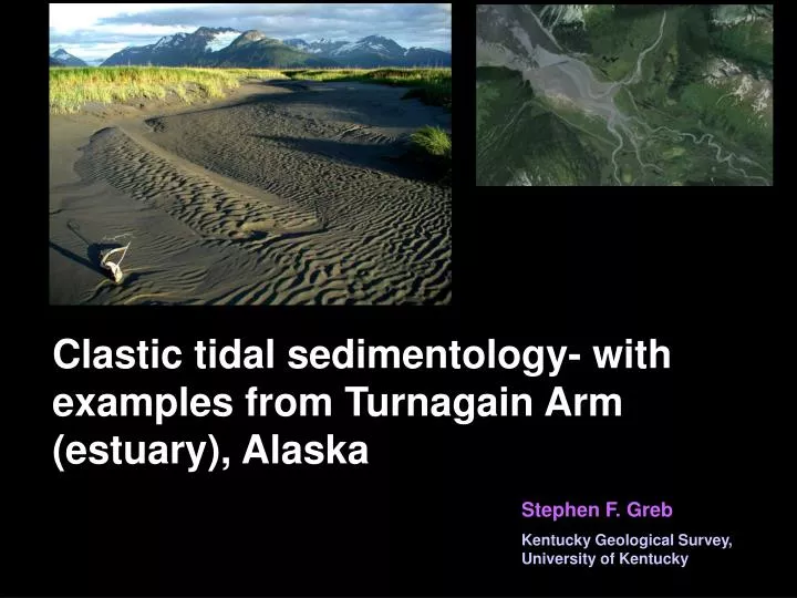
Clastic tidal sedimentology- with examples from Turnagain Arm (estuary), Alaska. Stephen F. Greb Kentucky Geological Survey, University of Kentucky. Outline Tides introduction Estuaries introduction Turnagain Arm, Alaska Glacier Creek study area Tidal rhythmites

E N D
Clastic tidal sedimentology- with examples from Turnagain Arm (estuary), Alaska Stephen F. Greb Kentucky Geological Survey, University of Kentucky
Outline • Tides introduction • Estuaries introduction • Turnagain Arm, Alaska • Glacier Creek study area • Tidal rhythmites • Scales of rhythmicity • Controls on rhythmite preservation
Deltas How many of you have seen this diagram before? http://www.pnas.org/content/104/43/16804/F1.large.jpg
Deltas • Deltas are large sedimentary deposits formed when sediment from rivers dumps into a lake or sea • Deltas have different shapes depending on the relative strength of river vs. tide. Vs. wave energy
Deltas vs. estuaries River Deltas in previous diagram River-dom Wave-dom Tide-dom Estuaries (Wave-dom) (Tide-dom) Strand plains/beaches Tidal flats Wave Tide Dalyrmple et al (1992)
Tides Major tidal forces (constituents) • Principal lunar (1 high, 1 low) P= 12.4 hours • Principal solar (1 high, 1 low) P= 12 hours Lunar tide creates a semidiurnal force with approximately two high tides each day (P=24.8 hours)
Tides Major tidal forces (constituents) Spring Spring When sun and moon align = additive lunar and solar forces = high (spring) tides
Tides Major tidal forces (constituents) Neap Neap When moon is at right angles to sun = opposing tidal forces = low (neap) tides
Tides Major tidal forces (constituents) • Principal lunar (1 high, 1 low) P= 12.4 hours • Principal solar (1 high, 1 low) P= 12 hours But the world isn’t covered by water uniformly. Continents in the way, different bathymetries, slope, etc. so tides act differently in different parts of the world • Semidiurnal ( 2 tides each day) • Diurnal ( 1 tide each day) • Mixed( 1 to 2 tides each day)
Tides Tides http://en.wikipedia.org/wiki/File:Diurnal_tide_types_map.jpg Distribution of tidal types varies
Tidal Range • Tidal constituent variations cause water to pile up in some areas more than others, so tides have different ranges: • Microtidal(0-2 m) • Mesotidal (2-4 m) • Macrotidal (4 m +) or (4-6 m) • Hypertidal(6 m+) Tidal range is dependent on a variety of factors including the tilt of the earth, bathymetry, phase and amplitude of tides, shape of the shelf and coastline, rate of shallowing landward, etc.
Tidal Range Tidal range also varies http://en.wikipedia.org/wiki/File:M2_tidal_constituent.jpg
Tidal structures Daily to twice daily changes in direction and amplitude of water acting on the sediment bed creates a variety of sedimentary structures What are some typical tidal structures?
Tidal structures A continuum of different types of ripple bedding occur in tidal facies • Flaser • Wavy • Lenticular Sand = white, Mud = black From http://www.kgs.ku.edu/Current/2008/Enos/gifs/fig10.gif
Tidal structures Herringbone cross stratification (xbeds or ripples) forms by current reversal* • But you need equal flow in both directions, and the space to stack one crossbed on another • Many so-called herringbone xbeds are really obliquely-aligned xbed troughs…be careful interpreting herringbone!!!
Tidal structures Herringbone cross stratification forms by current reversal* • Much more common are unequal tides, where dominant tide moves large dunes to form crossbeds in one direction and then subordinate tide moves smaller ripples on crossbedstopsets or on crossbedforesets in the other direction
Tidal structures Reactivation surfaces form by erosion of the bedform during flow reversal • Reactivation generally forms a slightly concavo-convex erosion surface, which cuts across multiple foresets
Tidal structures Mud drapes on foresets form as fines settle out during slack water between higher flow • Also common, during reversing flow or waning flow as currents change can simply result in low velocities or stagnation in which sand can’t be transported and silt-sized particles fall out of suspension leading to mud drapes on foresets Fine-grained drape
Tidal structures • Bundled foresets: • Tides don’t only increase and decrease and reverse daily, they also change during a neap-spring cycle http://www.seddepseq.co.uk/DEPOSITIONAL_ENV/Tidal/Picture2.png
Tidal structures • Bundled foresets: • Thicker foresets (d) form during higher energy (and velocity or duration) spring tides and thinner foresets form during neap tides http://www.seddepseq.co.uk/DEPOSITIONAL_ENV/Tidal/Picture2.png
Estuaries Definition • Estuaries are partly enclosed bodies of water, which are open to the sea at one end, and to rivers or streams on the other • Hence, they are influenced by shallow marine to fluvial processes Dalyrmple et al (1992)
Estuaries Definition • In some estuaries, headward narrowing causes tides to funnel landward, which tends to increase the amplitude of the tidal range (tides get higher) From Dalyrmple and Choi (2007)
Estuaries Models • The relative interaction of waves, tides, and rivers forms successions of sedimentary facies, which vary with the energy input into the system From Allen (1991)
Cook Inlet 0 50 100 km Alaska You are here Anchorage 2053 2047 2041 Cook Inlet Seward 2019 Knick Arm From Archer and Hubbard (2004) Turnagain Arm branch of Cook Inlet Anchorage 6th largest tidal range in the world Turnagain Arm Bathymetry and elevation maps from http://ibis.grdl.noaa.gov/cgi-bin/bathy/bathD.pl 0 25 50 km
Cook Inlet 0 50 100 km Alaska You are here Anchorage 2053 2047 2041 Cook Inlet Seward 2019 Knick Arm From Archer and Hubbard (2004) Tides are amplified partly because they are driven into funnel-shaped estuaries Anchorage Turnagain Arm Bathymetry and elevation maps from http://ibis.grdl.noaa.gov/cgi-bin/bathy/bathD.pl 0 25 50 km
0 50 100 km Alaska Turnagain Arm You are here Anchorage Hypertidal Anchorage 2053 2047 2041 Cook Inlet Tidal range (m) Seward 2019 From Archer and Hubbard (2004) Knick Arm Headward tidal amplification in the Turnagain Arm branch of Cook Inlet exceeds 10 m (35 ft) Anchorage Turnagain Arm Bathymetry and elevation maps from http://ibis.grdl.noaa.gov/cgi-bin/bathy/bathD.pl 0 25 50 km
12 Bird Point Girdwood 9 * 6 Hope 3 Anchorage 0 5 mi An Salinity measurements 10 11 11 8 Girdwood 6.5 Bpt 7 4 5 6 0 Hope 0 1 1 0 0 5 mi 1 Wi Neap Salinity Distance 12 - 7 = Marine, 6 - 1 = Brackish, 0 = Fresh An • In estuaries, salinity varies with neap-spring cycles and seasonal fluvial fluctuations 8* 10 7 Gi 9 Bp 5 5 6 Ho 0 0 0 1 Wi Spring Salinity
Girdwood Bird Pt. Hope A Chugach St. Pk. Headquarters 1 5 mi Bioturbation-Arenicolites • Outer estuaries where salinity is higher tend to have bioturbated tidal flats IntertidalFlats at low tide
Girdwood Bird Pt. Hope A Chugach St. Pk. Headquarters 1 5 mi Bioturbation-Arenicolites • Bioturbation often destroys original sedimentary structures Flats at low tide
12 Bird Point Girdwood 9 * 6 Hope 3 Anchorage 0 5 mi An Salinity measurements 10 11 11 8 Girdwood 6.5 Bpt 7 4 5 6 0 Hope 0 1 1 0 0 5 mi 1 Wi Neap Salinity Distance 12 - 7 = Marine, 6 - 1 = Brackish, 0 = Fresh An • Headward in estuaries, salinity decreases and bioturbation decreases 8* 10 7 Gi 9 Bp 5 5 6 Ho 0 0 0 1 Wi Spring Salinity
1 Knick Arm Turnagain Arm 25 50 km 0 An Headward funneling and shallowing increases the relative tidal range resulting in a breaking wave = tidal bore Study area Bird Point Indian Bore viewing Turnigan Arm Girdwood Hope 20-mile 5 mi Portage Placer Anchorage • 1.2-1.8 m high bore
An 8* 10 7 Bird Pt. Girdwood 9 5 5 6 Hope 0 20-Mile Creek 0 1 Wi Spring Salinity 5 mi 20-mile Creek The headward end of estuaries is usually a stream or river. Turnagain Arm has three fluvial channels
An 8* 10 7 Bird Pt. Girdwood 9 5 5 6 Hope 0 20-Mile Creek 0 1 Wi Spring Salinity 5 mi 20-mile Creek Tidal structures and bidirectional bedforms give way headward to fluvial, down-dip-oriented structures
3 mi 5 km 1 Here’s another type of bedding. The study flat is located where Glacier Creek empties into Turnagain Arm (near Girdwood). Girdwood Anchorage Study area Turnagain Arm 5 mi
rising tide The study flats are situated in a reentrant in the sedge marsh (light green) where Glacier Creek is deflected westward into the arm. 2003 channel Glacier Creek Low tide
The current peat marsh (which is the high high tide mark (fresh water) is 2.74 m above a gravel bed the flats are accreting on
Tidal Range/ 2003 35 Spring 30 Neap 25 20 Height (ft) 15 10 5 0 8/12 8/14 8/16 8/18 8/20 8/22 8/24 8/26 The tidal flats in the reentrant are influenced by twice daily (semidiurnal) tides.
Here are trenches of the flats, which contain stacked parallel-laminations, and soft-sediment deformation
A flag and washer was placed on one day, and then we came back to dig it up after one half day; another at one day; another after a week D 1 tide
Tidal structures A single day’s tide resulted in a thick-thin couplet consisting of two sand laminae draped by mud drapes = Half day’s dominant tide followed by a subordinate tide S D 1 day
Tidal structures These are stacked in groups or bundles of rhythms representing longer time periods N S S D N 1 day 2 week 1 month
Tidal structures Rather than bundled foresets in laterally migrating crossbeds, these are vertically-accreted laminae N S S D N 1 day 2 week 1 month
2004 Glacier Ck 20 m 8/2003 7/2004 In 2004, we monitored sedimentation on the flats for 10 days and trenched flat in several locations to examine controls on rhythmite deposition and preservation Sedge marsh is ~2m above low tide level
Completely buried tile Placing washers and flags Partially buried tile
Natural weathering shows two distinct thickness trends in preserved tidal bundles • Bundles with thin couplets • Bundles with thick couplets
470 mm Trench 2 14 Soft-sediment deformation 12 10 8 Laminae thickness (mm) 6 4 2 0 Soft-sediment deformation 1 7 13 19 25 31 37 43 49 55 61 67 Flags with washers showed twice daily sedimentation • Trenches showed cyclic bundles of 14 to 10 laminae (5 to 7 laminae couplets) • Also, zones of soft-sediment deformation Glacier Ck 20 m
Soft-sediment deformation is likely due to dewatering of the flats
Glacier Ck Trench 3 Alternating spring (S) bundles of thicker laminae couplets and thinner laminae couplets represent perigee (Sp) high-spring and apogee (Sa) low-spring tides Soft-sediment deformation 12 Sp Sp Sp 10 Sa 8 Sa Laminae thickness (mm) n n n n 6 4 2 0 1 7 13 19 25 31 37 43 49 55 320mm thick Soft-sediment deformation 20 m
Tidal Range/ 2003 35 Spring 30 Neap 25 20 Height (ft) 15 10 5 0 8/12 8/14 8/16 8/18 8/20 8/22 8/24 8/26 There is 2 m of relief between the marsh (spring high tide) and the alluvial gravel apron, which means that 3 to 4 days of neap tides don’t cover the flats
20 m Composite results of trenching showing changes in rhythmite signal laterally as flats thinned