Semantically-Assisted Geospatial Workflow Design
This paper discusses semantically-assisted geospatial workflow design, highlighting the role of open standards from the Open Geospatial Consortium (OGC) in creating effective workflows. It explores the integration of semantic technologies and web services like WMS, WFS, and WPS to support diverse geospatial applications, particularly in emergency management, geographic modeling, and climate change scenarios. The implementation of a prototype and innovative algorithms for workflow similarity is also presented, aiming to improve user experience in constructing complex workflows and enhance OGC interoperability.

Semantically-Assisted Geospatial Workflow Design
E N D
Presentation Transcript
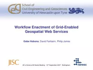
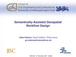
Semantically-Assisted Geospatial Workflow Design Gobe Hobona, David Fairbairn, Philip James g.e.hobona@newcastle.ac.uk ACM GIS – 8th November 2007 - Seattle
Overview • Background • OGC Web Services • Workflow Enactment • A Role for Semantics • Prototype Implementation • Conclusions
Background • Open Geospatial Consortium (OGC) • JISC Grid/OGC Collision Programme • Security : SEE-GEO • Workflow : SAW-GEO • OGC Interoperability Experiments (OWS-4 and beyond) • Challenge: How to support the user in the construction of workflows to address a variety of problems?
OGC Web Services • Web Map Services (WMS) • Generates geovisualisations/maps from any geo-data source • Web Feature Services (WFS) • Disseminates vector geospatial data • Web Coverage Services (WCS) • Disseminates raster geospatial data • Web Processing Services (WPS) • Runs geocomputational models or geospatial operations on user-supplied datasets
Workflow Enactment • Recognised by ISO19119 • Several options for workflow enactment • SCUFL, BPEL, Keppler etc • Selected BPEL because • OASIS Standard, i.e. WS-BPEL 2.0 • Multi-vendor support including IBM, Sun Microsystems, ActiveEndpoints, Oracle etc • Availability of open source enactors
An Example Geospatial Workflow WPS 1 Generalise WFS Workflow Enactor client WPS 2 Clip Based on OGC OWS-4 GeoProcessing Workflow Scenario
Possible Applications for Geo-Workflows • Emergency Management • Where each activity depends on the result of a previous activity • Geographic modelling • Where several steps are needed before a final model is produced e.g. ESRI Model Builder • Climate Change scenarios • Where a number of possible routes for workflows are possible depending on the state of certain variables
Concept 1 Concept 2 Concept 3 Concept 4 SUBSUMPTION EXACT Concept 3 Concept 1 Concept 5 A Role for Semantics in Orchestration Problem Domain SOA Services Resources Workflow enactor
Thing B D C E A J L K M I Calculating Workflow Similarity (1) Key: X A concept A path linking two concepts. The concept on the ‘arrow-head’ subsumes the other A path through several other concepts
Proposed Formula • α is an application-specific weight applied to each activity in the workflow • n is the number of activities in the requested workflow • Pk is the number of edges between the concept representing the kth activity in the workflow and the concept tagging a candidate service
A Geospatially aware Ontology • Earth and environmental problem domains present problems of space • Requiring a geo-aware ontology • SWEET* • Earth Realm • Physical Process • Physical Property • Non-Living Substances • Living • Data • Human Activity • Numerics • Natural Phenomena • Space • Time • Units * Raskin, R. G. and Pan, M. J. Knowledge representation in the semantic web for Earth and environmental terminology (SWEET).Computer & Geosciences, 31, 9 (2005), 1119-1125.
Implementation • SWEET ontology uploaded from OWL documents into PostgreSQL • Metadata held in a conventional DBMS with a catalogue service interface • For each query, semantically related concepts found using Jena • Additional methods implemented to calculate the number of edges
Architecture Eclipse IDE BPEL Editor SAW-GEO Plug-In Client-side Server-side Catalogue Service Jena Metadata Ontology
Search Concept Number of edges between Search Concept and tag Response from Search <Result class="http://sweet.jpl.nasa.gov/ontology/space.owl#AdministrativeRegion"> <Resource id="tiger:poly_landmarks@http://geoserver.itc.nl:8080/geoserver" edges="0" type="wfs" owl="http://sweet.jpl.nasa.gov/ontology/space.owl#AdministrativeRegion"/> <Resource id="topp:tasmania_state_boundaries@http://gist.fsv.cvut.cz:8080/geoserver" edges="1" type="wfs" owl="http://sweet.jpl.nasa.gov/ontology/space.owl#Region"/> <Resource id="tiger:giant_polygon@http://geobrain.laits.gmu.edu:8099/geoserver" edges="2" type="wfs" owl="http://sweet.jpl.nasa.gov/ontology/space.owl#SpatialObject"/> </Result>
Ontology and Suggested Flow views ‘plugged into’ ActiveBPEL Designer
Evaluation • 15 OGC web services with 180 resources compiled from a Google search for GetCapabilities documents • Resources tagged with references to OWL Concepts • Tags assigned according to specialist words in resource titles • Resource titles obtained from GetCapabilities methods • Average response time for discovery and edge count • Greatest cost where several resources are tagged with concepts ‘far away’ from the search concept • Possibilities for parallelisation as each concept can be searched for on a separate machine
Conclusions and Future Work • Proposed formula offers an algorithmic approach for comparing linear workflows • Limitations to complete automation due to variations between properties of service inputs and outputs • Future work should investigate non-linear workflows and the inclusion of conditional activities • Need for a test corpus for evaluating catalogues of OGC web services Thank You g.e.hobona@newcastle.ac.uk


![[1] semantically annotated accommodations](https://cdn1.slideserve.com/2531262/slide1-dt.jpg)