Download
1 / 17
170 likes | 189 Vues
Understand NPDES Stormwater Phase II, mapping outfalls in Hamilton County using GIS, minimum control measures addressed, lessons learned, benefits of collaboration.

E N D
Managing NPDES Phase II Requirements on a County-Wide Basis Jared Livingston
What I am Going to Talk About: • Brief overview of NPDES Storm Water Phase II. • What outfalls are and how they are being mapped for Hamilton County. • Which of the Minimum Control Measures this project helps to fulfill and how. • Role of GIS. • The lessons we have learned. • The benefits of joining forces.
Overview of NPDES Stormwater Phase II • What is NPDES Stormwater Phase II? • Who is required to comply with NPDES Phase II? • What does the NPDES permit require? • What are the six Minimum Control Measures?
What is NPDES Stormwater Phase II? Permitting system that places controls on operators of small regulated municipal separate storm sewers systems (MS4s) in order to improve the water quality of discharges from their storm sewer facilities.
Who is required to comply with NPDES Phase II? • Regulated small MS4s - MS4s located within “urbanized area” and having a population between 50,000 and 100,000. • MS4s located outside an urbanized area and serving a population of at least 10,000. • MS4s located outside an urbanized area that connect to a regulated small MS4.
What does the NPDES permit require? Implementation of a storm water management plan (SWMP) including, at minimum, selection and execution of appropriate Best Management Practices (BMPs) and measurable goals for each of the six minimum control measures. The ultimate goals of the SWMP are: • Reduction of pollutant discharge to the “maximum extent practicable” (MEP). • Protection of water quality. • Compliance with the water quality standards of the Clean Water Act.
What are the six Minimum Control Measures? • Public Education and Outreach • Public Participation/Involvement • Illicit Discharge Detection and Elimination • Construction Site Runoff Control • Post Construction Runoff Control • Pollution Prevention/Good Housekeeping
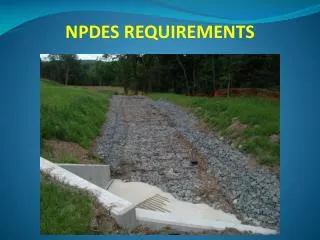
What is an outfall and how are Hamilton County’s outfalls being mapped? An outfall is the place where storm water is discharged into receiving waters. An outfall can be a pipe or the mouth of a stream.
What is an outfall and how are Hamilton County’s outfalls being mapped? Hamilton County’s outfalls are being mapped using a combination of differential GPS and Woolpert’s proprietary field data collection software, SmartSurveyor™.
What is an outfall and how are Hamilton County’s outfalls being mapped?
Which of the 6 Minimum Control Measures are being addressed and how? • Public Education and Outreach • Public Participation/Involvement • Illicit Discharge Detection and Elimination • Construction Site Runoff Control • Post Construction Runoff Control • Pollution Prevention/Good Housekeeping
Storm sewer system map showing all outfalls. Dry weather screening Illicit Discharge Detection and Elimination • Documentation of actions and results
Pollution Prevention/Good Housekeeping Discovering the source of illicit discharges found while mapping outfalls can be used as a starting point for compliance with this minimum control measure. It would help to identify the most effective BMPs by targeting known problem areas.
What is the role of GIS in the arena of NPDES Phase II Compliance? + GIS provides a multi-faceted, dynamic repository for NPDES outfall data. +
What lessons have we learned? • Ideal times of year to perform field mapping operations: late spring through early fall. • GPS signal surprisingly strong under summer canopy. • Perform field mapping operations during dry weather conditions. • Collect EVERYTHING you see. • It is a two person job. • Not all attributes collected in the field need to be included in the GIS data set.
Benefits of joining forces to fulfill NPDES Stormwater Phase II requirements • Share authority to pass and enforce legislation. • Share knowledge. • Share costs. • Maximize efficiency.