Download

1 / 18
180 likes | 902 Vues
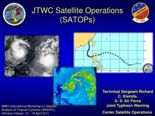
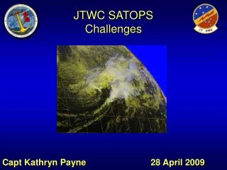
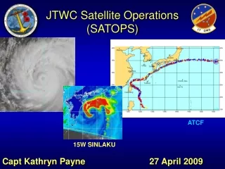
JTWC Satellite Operations (SATOPS). ATCF. 15W SINLAKU. Capt Kathryn Payne 27 April 2009 . Overview. SATOPS overview Satellite fix statistics 2008 METSAT Conference Conclusions Microwave Constellation Quikscat Improvements to Intensity Estimates. SATOPS Mission.

E N D
JTWC Satellite Operations(SATOPS) ATCF 15W SINLAKU Capt Kathryn Payne 27 April 2009
Overview • SATOPS overview • Satellite fix statistics 2008 • METSAT Conference Conclusions • Microwave Constellation • Quikscat • Improvements to Intensity Estimates
SATOPS Mission • JTWC now has the sole Tropical Cyclone (TC) Reconnaissance Mission in USPACOM • Support JTWC TC Forecast Operations • METWATCH AOR for disturbances • Evaluate disturbances for TC genesis • Assess TC position/intensity • Synergistic relationship with Typhoon Duty Officers (TDOs) • Post-storm F-deck QC • Transition research to operations through collaboration
Organizational Structure SATOPS: 1 AF Capt + 5 AF Enlisted + 2 AF civilians = 8 total
SATOPS Tools • USAF / MARK IVB Satellite System • USN / FMQ-17 Satellite System • Automated Tropical Cyclone Forecast System (ATCF) • Geo-referenced • From FNMOC/NRL • FNMOC and NRL TC Web Pages
Fixing Process • Position Fix every 3 hours • VIS, IR, Multi-spectral • Intensity Estimate every 6 hours • Dvorak Technique • Code and Transmit Bulletin • Process Other Agencies’ Fixes • Radar/Dropsonde fixes • Microwave Fixes as available • Now transmitted longline JAAWIN
2008 Satellite FixesBy Agency 9199 5% 16% 744 1951 96 6% 266 73% 69 51 29 126 45 5 Total Satellite Fixes = 12,581
2008 Geostationary Fixes By Platform (PGTW) 2% 36% 2504 62% 1462 77 27 Total Geostationary Fixes = 4,070
2008 Microwave Fixes By Platform (PGTW) 5% 15% 1716 34% 869 9% 644 17% 364 453 781 7% 284 13% Total Microwave Fixes = 5,111 Over half of PGTW fixes are now microwave
Apparent LLCC True LLCC Exposed LLCC Sheared Convection Slide courtesy of Jeff Hawkins, NRL
METSAT Conference Topics • Future of Satellites Improvements to operational intensity estimates • Participants • JTWC • NPOESS • NESDIS Satellite Analysis Branch • Naval Research Lab (NRL) • Fleet Numerical (FNMOC) • University of Wisconsin, CIMSS • NOAA-Science and Technology • Remote Sensing Systems • Lockheed Martin (Mark IVB) • SeaSpace (FMQ-17/TeraScan) • NWS Guam
Polar Satellite Programs DMSP F19 NPOESS C2 DMSP F16 DMSP F20 DMSP F18 NOAA 17 MetOp-A MetOp-B MetOp-C MetOp-D NOAA 18 NOAA 19 NPP Slide courtesy of Maj Chris Dennison (NPOESS) Calendar Year 2007 2008 2009 2010 2011 2012 2013 2014 2015 2016 2017 2018 2019 2020 2021 2022 2023 AM Orbit DMSP F17 MidAM Orbit PM Orbit NPOESS C3 NPP NPOESS C1 Defense Meteorological Satellite Program (DoD) NPOESS Preparatory Project (NASA/NOAA) Extended operation European Polar System (EUMETSAT) NPOESS(NOAA/DoD/NASA) Satellite is beyond design life Previous Schedule (through November 2008) NOAA Polar Satellite Program
Future of Satellites-Conclusions • JTWC needs assistance in quantifying satellite platforms’ impact to operations • Ex: reduction in forecast errors, $ saved, sorties prevented • JTWC needs a systematic way to advocate for satellite programs (ex. GCOM scatterometer/AMSRE) • A temporal sampling requirement is needed for microwave imagery/sounders • Ex: imagery needed every 3 hours • Request increased resolution for MIS (NPOESS) sensor
Quikscat • Essential to JTWC operations • Synoptic Analysis • Initial warnings often based on quikscat winds • Windsat/ASCAT- poorer spatial resolution • First scheduled replacement- Dual Frequency Scatterometer (DFS) 2016 • Potential to run second ASCAT 20 minutes after 1st • ASCAT flies on MetOp series Quikscat Windsat Ascat
Dvorak Technique • Due to lack of aircraft recon, Dvorak primary tool for intensity estimates • Known weaknesses in Dvorak present problems for TDO/analyst • Few updates to process in 30 years • Subjectivity • Rapid intensification • Weakening systems • Weak, developing systems • Midgets/pinhole eye
Improvements to Intensity Estimates • Need correct baseline intensity to improve intensity forecasting • Investigate use of CIMSS’ SATCON (Satellite Consensus) intensity estimate as a supplement to Dvorak • Weighted consensus of 3 automated satellite intensity estimates • ADT (Advanced Dvorak Technique) • AMSU (CIMSS) • AMSU (CIRA) • Collaborate to improve understanding of these intensity estimates • Priority for improvements concern storms less that 35 kts and rapid intensifiers
SATOPS Contacts • OIC – Capt Kathryn Payne Capt Stephen Chesser (Aug 09) • NCOIC – TSgt Ken Viault MSgt Mike Oates (TBD) • E-Mail: firstname.lastname@navy.mil • Duty Satellite Analyst: • Commercial: (808) 471-3533 • DSN: (315) 471-3533 • SATOPS Office: • Commercial: (808) 474-3946 • DSN: (315) 474-3946