Download
1 / 32
330 likes | 540 Vues
A Brief Overview of U.S. Arctic Policy and the U.S. Extended Continental Shelf Project. Brian Van Pay Office of Ocean and Polar Affairs U.S. Department of State. Arctic Domain Awareness Conference National Geospatial-Intelligence Agency St. Louis, Missouri March 4-5, 2009.

E N D
A Brief Overview of U.S. Arctic Policy and the U.S. Extended Continental Shelf Project Brian Van Pay Office of Ocean and Polar Affairs U.S. Department of State Arctic Domain Awareness Conference National Geospatial-Intelligence Agency St. Louis, Missouri March 4-5, 2009
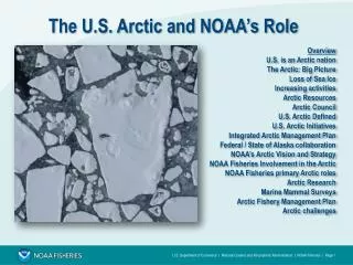
Where is the Arctic? • All land, submerged lands, and water north of Arctic Circle (66º33’39’’N) • U.S. Arctic Research Commission statute includes Bering Sea and a portion of land area of Alaska below the Arctic Circle • Canadian Arctic Waters Pollution Prevention Act includes all Canadian land and waters north of 60º N • Denmark considers all of Greenland and the Faroe Islands as Arctic • Biogregions (tree line, where permafrost begins, etc) Where is the Arctic Ocean? • Definition adopted by IHO in 1953. Neither has a definitive and obvious extent. The United States has an interest in not subscribing to one particular definition for all purposes. Rather each definition serves its own purpose.
International Law in the Arctic • Convention on the Law of the Sea • Various IMO agreements • Numerous treaties (Stockholm Convention, 1973 Treaty on the Conservation of Polar Bears, UNFCCC, etc) • So-called “soft law” applicable to the Arctic Ocean (IMO guidelines, Arctic Council Guidelines, etc). • All five coastal States (U.S., Russia, Canada, Norway, and Denmark/Greenland) stated in the Illulissat Declaration that there is no need for a comprehensive Arctic treaty. • U.S. is open to discussing the need for other agreements (e.g. fisheries, SAR). There are many sources of international law that are applicable to the Arctic Ocean, and, more importantly, available to enhance the security, environmental protection, and safety of navigation of the Arctic Ocean.
Arctic NSPD/HSPD • New policy released January 9, 2009 • Extensive interagency discussions, led by State • Addresses 7 themes: • National Security and Homeland Security • International Governance • Extended Continental Shelf and Boundary Issues • Promoting International Scientific Cooperation • Maritime Transport • Economic Issues, including Energy • Environmental Protection and Conservation of Natural Resources • Identifies lead agency or agencies for each theme. • Written in a manner that it would represent enduring U.S. interests and could remain as official U.S. policy from one administration to the next.
Arctic Council • Established in 1996. • Membership limited to States with land north of the Arctic Circle and “Permanent Participants” representing indigenous peoples. There are also observer States and organizations. • Only diplomatic forum focused on the entire Arctic. • Senior Arctic Officials (SAOs) and permanent participants jointly coordinate Council operations. • Arctic Council Ministers meet every 2 years. Chairmanship rotates among the member States every 2 years. • Work is project-driven and focused on environmental protection and sustainable development. Military security is excluded. • Substantive work takes place mostly in six working groups. • Various assessments and reports often result in recommendations on actions to be taken by member States and organizations.
Challenges Ahead: Climate • Climate change is having a dramatic impact on Arctic ecosystems and Arctic residents. • The science of climate in the Arctic is generally two-pronged: • Looking at effects of climate change on the Arctic. Change is happening faster in the Arctic than in any other region in the world. • Science is trying to understand the way in which changes in the Arctic affect global climate, as well as the way global climate change feeds back into the changes taking place in the Arctic. • The recently-concluded IPY has contributed much to this understanding, and results will continue to be analyzed over the coming years. • The U.S. and others have maintained the proper place for setting climate policy is in the UNFCCC process.
Challenges Ahead: Search and Rescue (SAR) • Tourism is increasing. Concern there are not adequate SAR resources or ships adequately equipped for operating in the harsh environment. • Destinational shipping is expected to increase in the short term and trans-Arctic shipping is expected to increase in the long term. • The U.S. has proposed to the Arctic Council the creation of a special task force on search and rescue in the Arctic that we anticipate will be approved at the April Ministerial. • We expect the task force will assess the current status of: • the patchwork of SAR instruments in the region • identifying gaps in the existing instruments • looking at ways to move forward to enhance SAR in the Arctic in the face of anticipated use.
Challenges Ahead: Shipping Arctic Marine Shipping Assessment (AMSA) • U.S. is a lead country, along with Canada and Finland, on the first ever Arctic Marine Shipping Assessment (AMSA). • The final assessment is expected to be approved and released at the April 29 Tromsø Ministerial meeting of the Arctic Council. • Comprehensive review of the history, current status, and likely future of shipping in the Arctic. • Includes findings and recommendations that will hopefully inform the policies of Arctic States and others with a stake in Arctic shipping.
Media Attention Extended Continental Shelf
1982 Convention on the Law of the Sea • “Constitution of the Oceans” • maritime zones, freedom of navigation, fishing, marine scientific research, piracy, marine pollution… • Entered into force on November 16, 1994 • 157 Parties • Three LOS Institutions Established: • International Seabed Authority (ISA) • International Tribunal on the Law of the Sea (ITLOS) • Commission on Limits of Continental Shelf (CLCS) • U.S. has not acceded • Must go to Senate Foreign Relations Committee (SFRC) for a vote before it can be sent to Senate floor
1982 Convention on the Law of the Sea Under international law, every coastal State gets a 200-mile shelf automatically. Some coastal States can claim an extended continental shelf beyond 200 miles IF the shelf meets the criteria under Article 76 of the Law of the Sea Convention
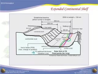
Article 76: Paragraph 4 Formula Lines: Two Options Paragraph 4: 4(a)ii – FOS + 60M 4(a)i – FOS & sediment thickness Coast/Baseline 200 nm EEZ Foot of the slope Sediments 60nm 1% of distance to foot of slope Crystalline continental crust Oceanic crust 0 100 200 300 400 nautical miles (nm)
Article 76: Paragraph 5 Constraints to the ECS Limit: Two Options Paragraph 5: Max 1: 350 nm from baselines OR Max 2: 2,500 m isobath plus 100 nm Coast/Baseline 200 nm EEZ Max 1 Max 2 350 nm Sediments 2,500 m isobath 2,500 m isobath + 100 nm Crystalline continental crust Oceanic crust 0 100 200 300 400 nautical miles (nm)
ECS Data Collection Bathymetric Data Seismic Data Baselines (i.e. updated charts) Other Supporting Data (gravity, magnetic, samples, etc)
Why does it matter? • The U.S., like other countries, has an inherent interest in knowing, and declaring to others, the exact extent of our sovereign rights. • Sovereign rights over the natural resources of seabed and subsoil: • mineral resources (manganese nodules, ferromanganese crusts, and polymetallic sulfides, etc) • petroleum (oil, gas, and gas hydrates) • “sedentary” species (clams, crabs, scallops, sponges, corals, mollusks, etc) • Defining those rights in concrete geographical terms provides the specificity and certainty necessary to protect, manage, and/or use those resources.
The U.S. Extended Continental Shelf More than 1 million square kilometers • The United States has an extended continental shelf (ECS) that is more than 1 million square kilometers—an area nearly half of the Louisiana Purchase and with energy and mineral resources that are likely worth many billions. • Defining and establishing the limits of the ECS in concrete geographical terms will enable the U.S. to exercise its sovereign rights over these resources with significantly greater certainty -- whether we choose to use or conserve those resources. Coast/Baseline 200 nautical miles Continental Shelf Extended Continental Shelf (ECS)
How to Establish an ECS • Conduct a study with existing data • Collect additional data, especially bathymetric and seismic • Analyze data and identify ECS limits LOS Party • Makes submission to CLCS • CLCS reviews, makes recommendations to Coastal State • Limits “final and binding” LOS Non-Party • Can establish outer limits but doesn’t get benefit of Convention procedures to maximize international recognition and legal certainty
Commission on the Limits of the Continental Shelf (CLCS) • A coastal State submits its coordinates, data, and analyses to CLCS. • 21 members, all scientists. Elected by State Parties. • Executive summary and coordinates are posted on its public website. No provision for the disclosure of the submission or supporting data. • Subcommission of seven members reviews individual submissions. • No mandate to settle boundary disputes. • If the coastal State establishes its ECS limits “on the basis of” CLCS recommendations, those limits are “final and binding.” • Purpose? International recognition.
Other Countries • About 60 countries have an ECS • A majority have begun work to define their shelf • 18 of those countries have made a submission in whole or in part: • Russia • Brazil • Australia • Ireland • New Zealand • “FISU” Joint Submission • France (New Caledonia and French Guiana) • Ireland • Norway • Mexico • Bahamas • United Kingdom (Ascension Island) • Indonesia • Japan • Seychelles/Mauritius Joint Submission • Suriname • Burma • France (French Antilles and the Kerguelen Islands) • 5 recommendations issued in whole or part: • Russia • Brazil • Australia • Ireland • New Zealand
Australia’s ECS 3,371,990 square km, or 45% of Australia’s land mass ECS EEZ ECS
In April 2007, the Interagency Committee on Ocean Science and Resource Management Integration (ICOSRMI), Co-chaired by the Office of Science and Technology Policy and the Council on Environmental Quality, established the Extended Continental Shelf Task Force. The Task Force is chaired by the Department of State with co-vice chairs from the Department of the Interior and the National Oceanic and Atmospheric Administration. The Task Force is to coordinate the collection and analysis of relevant data and prepare the necessary documentation to establish the limits of the U.S. continental shelf in accordance with international law.
What has been done so far? • Bathymetric Data Collection (more than 1 million square kilometers from 13 cruises) • Arctic Ocean (2003, 2004, 2007, 2008) • Gulf of Alaska (2005) • Gulf of Mexico (2007) • Atlantic Ocean (2004, 2005, 2008) • Northern Marina Islands & Guam (2006, 2007) • Bering Sea (2003) • Seismic Data Collection (more than 2,700 linear kilometers) • Arctic Ocean (2008) • Data Management • Developing metadata standards for bathymetric and seismic data (2008) • Developing a long-term data management and preservation strategy (2008) • Planning • Held 4 regional geology workshops with experts from industry and academia. Northern Mariana Islands East Coast Gulf of Mexico
What work is left? • Planning • Project Plan, due June 2009 • Determine priorities • Execute remaining work • Data Collection • Additional bathymetric data required (Arctic, Gulf of Alaska, Continental West Coast, Pacific Islands) • Additional seismic data required (Arctic, Continental East Coast, possibly elsewhere) • Analysis and Compilation • Construct a Geographic Information System • Apply formula and constraint lines • Document legal and scientific approaches Planning Data Collection Analysis and Compilation
Arctic Data Collection Missions 2003 • U.S. bathymetric data collection from Healy (10 days) 2004 • U.S. bathymetric data collection from Healy (20 days) 2007 • U.S. bathymetric data collection from Healy (30 days) • Canadian seismic data collection from Louis S. St. Laurent with a U.S. Observer onboard (60 days) 2008 • U.S. bathymetric data collection from Healy (23 days, Aug 14-Sept 5) • Joint U.S. – Canadian seismic (from Louis) and bathymetric (from Healy) data collection (Joint mission is 26 days, Sept 6-Oct 3, but Canada collected seismic data for ~42 days) 2009 • Healy and Louis cooperatively collecting seismic and bathymetric data in the Arctic for 41 days (Aug 7-Sept 16). 2010 • Healy and Louis likely working together again.
Why Cooperate? • Mutual interest to define continental shelf in the Arctic • Saves millions for both countries • It’s Canada and the U.S.—we’re friends. And we also have a long history of scientific collaboration. • Utilize collective, rare expertise, especially given the challenges of the Arctic. • Collect data only once over the same area • Provide data the other needs • Canada has a proven multi-channel seismic system that works in ice-covered conditions • The Healy has a multibeam bathymetric system and can clear a path
Maximizing the Effort (Science) Guyots off Northern Mariana Islands, one less than 7 meters from surface Dendritic drainage patterns off Northern Mariana Islands Mystery Grooves Iceberg Scours Healy Seamount
Maximizing the Effort (Science) Dredge Samples
Common Misconceptions • The following are not accurate: • A State claims an extended continental shelf. • The CLCS approves a State’s continental shelf. • The CLCS is part of the United Nations. • Defining an ECS is an Arctic-only endeavor. • The U.S. does not have ECS unless we accede to the Convention. • Climate change is the stimulus for defining an ECS in the Arctic. • This is a race for resources. • Russia is taking U.S. ECS. • Maritime boundaries in the Arctic are different.
Questions? Brian Van Pay Office of Ocean and Polar Affairs U.S. Department of State vanpaybj@state.gov 202-647-5123 Julie Gourley Senior Arctic Official gourleyjl@state.gov 202-647-3264