Download
1 / 1
10 likes | 154 Vues
Real-time data and communications services of NCAR ’ s Earth Observing Laboratory Chris Webster 1 , Mike Daniels 1 , Greg Stossmeister 1 1) National Center for Atmospheric Research, Boulder, CO. Introduction. World-wide Internet Relay Chat for Mission Control.

E N D
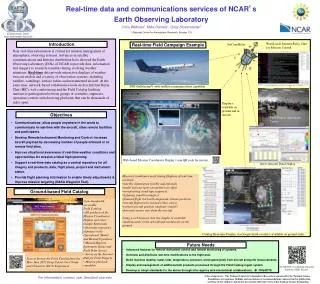
Real-time data and communications services of NCAR’s Earth Observing Laboratory Chris Webster1,Mike Daniels1, Greg Stossmeister1 1) National Center for Atmospheric Research, Boulder, CO Introduction World-wide Internet Relay Chat for Mission Control Real-time Field Campaign Example SatCom Relay Near real-time information is critical for mission management of atmospheric observing systems. Advances in satellite communications and Internet distribution have allowed the Earth Observing Laboratory (EOL) of NCAR to provide data, information and imagery to research scientists during evolving weather situations. Real-time data provide interactive displays of weather forecast models and a variety of observation systems, including satellite, soundings, surface radars and instrumented aircraft. At the same time, network-based collaborative tools such as Internet Relay Chat (IRC), web conferencing and the Field Catalog facilitate interactive participation between groups of scientists, engineers, operations centers and observing platforms that can be thousands of miles apart. ammonium sulfate NSF Gulfstream V with satellite communications capability Displays available on ground and in aircraft soot carbon from combustion Objectives • Communications: allow people anywhere in the world to communicate in real-time with the aircraft, other remote facilities and participants. • Develop Remote Instrument Monitoring and Control: increase aircraft payload by decreasing number of people onboard or at remote field sites. • Improve situational awareness of real-time weather conditions and opportunities for mission-critical flight planning. • Support a real-time data catalog as a central repository for all imagery and products, data, flight plans, project and instrument status. • Provide flight planning information to enable timely adjustments & improve mission targeting (NASA Waypoint Tool). Field Project Operations Center Web-based Mission Coordinator Display (scan QR code for movie) Aeros Aircraft Data Display • Mission Coordinator and Catalog Displays of real-time overlays: • satellite information (visible and infrared) • model forecast (grey streamlines on right) • overshooting cloud-tops (squares) • lightning (small rectangles) • planned flight track with dropsonde release positions • aircraft flight track (red and yellow curve) • current aircraft position (airplane symbol) • forward camera view from the aircraft. • Using a web browser, this live display is available simultaneously in the aircraft and world-wide on the ground. Ground-based Field Catalog • Low-bandwidth accessible • Field Catalog: • All products of the Mission Coordinator Display and other Google Earth kmls • Extensive repository of project-wide Operational, Model and Research products • Mission Reports, Instrument Status and Field Data Access • Serves as the Internet Hub for Field Projects • Mission playback capability Catalog Real-time Display via Google Earth overlays (available on ground only) Future Needs • Advanced features for remote instrument control and remote monitoring of systems. • Generate and distribute real-time modifications to the flight plan. • Build real-time weather radar, lidar, temperature, pressure, wind speed grids from aircraft and point measurements. • Display and management of additional kml products processed through the Field Catalog ingest system • Develop or adopt standards for the above through inter-agency and international collaborations. IWGADTS Scan to browse the Field Catalog from the May-June 2012 Deep Convective Clouds and Chemistry (DC3) Experiment NCAR/EOL’s Computing, Data and Software (CDS) Facility Acknowledgements: 'The National Center for Atmospheric Research is sponsored by the National Science Foundation. Any opinions, findings and conclusions or recommendations expressed in this publication are those of the author(s) and do not necessarily reflect the views of the National Science Foundation.‘ For information, contact: real_time@eol.ucar.edu