Download
1 / 1
10 likes | 221 Vues
IMAPP - International MODIS and AIRS Processing Package H.-L. Allen Huang, Liam Gumley, Thomas Rink, Jun Li, Elisabeth Weisz, Kevin Baggett, Xiangqian Wu, Kathy Strabala, Chris Moeller Cooperative Institute for Meteorological Satellite Studies, University of Wisconsin-Madison

E N D
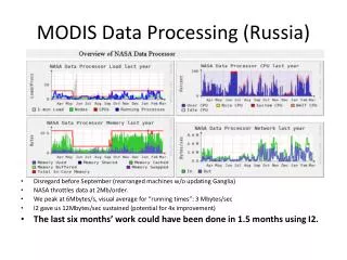
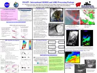
IMAPP - International MODIS and AIRS Processing Package H.-L. Allen Huang, Liam Gumley, Thomas Rink, Jun Li, Elisabeth Weisz, Kevin Baggett, Xiangqian Wu, Kathy Strabala, Chris Moeller Cooperative Institute for Meteorological Satellite Studies, University of Wisconsin-Madison and William L. Smith Langley Research Center, NASA • 2. IMAPP Software • SSEC is funded by NASA to develop the International MODIS/AIRS Processing Package (IMAPP). The goals of the IMAPP project include: • i. To release a freely available package for processing MODIS and AIRS/AMSU/HSB data, • ii. To promote and support the worldwide use of EOS data, and to involve the international community in EOS validation efforts. • For this purpose, SSEC has adapted the operational Level-0 to Level-1 MODIS geolocation and calibration software developed by NASA. The main differences are that IMAPP: • Has been ported to major UNIX platforms, • Requires only the NCSA HDF 4.1r3 toolkit, • Runs in a much simpler processing environment, • Can use downlink or definitive ephemeris/attitude, • Can process satellite overpasses of arbitrary size. • IMAPP may be downloaded at no cost, and is licensed under the terms of the GNU General Public License (GPL). IMAPP is now used in USA, UK, Germany, Russia, Japan, China, Korea, Singapore, and Australia to process Terra MODIS data. The latest release (v 1.3) was in December 2001, • Science algorithms currently under development for release as part of IMAPP include: • MODIS Cloud Mask • MODIS Temperature and Moisture Profiles • MODIS Cloud Top height, temperature, phase • Fire Detection (courtesy of MODIS Land Team) • AIRS/AMSU/HSB Level 0 to level 1 S/W • AIRS Temperature and moisture Profiles 5.1 Cloud Mask Product: February 12, 2002 (Real time Product) 1. IMAPP Revision History May 12th, 2000 (v1.0) Initial release for Terra MODIS November 1st, 2000 (v1.1) Calibration algorithm updated to version 2.4.3. April 13th, 2001 (v1.2) Calibration algorithm updated to version 2.5.5. December 3rd, 2001 (v1.3) Level-1A: fixed problems arising from bad Level-0 input Geolocation: fixed interpolation problems at pass boundaries Calibration: Algorithm updated to 3.0.0 ScanEX (Moscow) has ported IMAPP to Windows http://cimss.ssec.wisc.edu/~gumley/IMAPP/ Eastern Europe Oct. 3, 2001: MODIS scene acquired at the University of Dundee and processed by IMAPP. 3 color-composite Image (Band 1- R; Band 6 - G; Band 7 -B) Red-Snow; White-Clouds; Aqua-Clear Ground 12 Feb., 2002 17:23 UTC Blue - Clear (probably) Green - clear (confident) Red - Uncertain White - clouds MODIS & AIRS Cloud Clearing Demonstration Clear Column Radiance Results With and without MODIS 2x2 ~ 4 Km Resolution 3x3 ~ 6 Km Resolution 4x4 ~ 8 Km Resolution 6x6 ~ 12 Km Resolution MODIS N*/MODIS Filter Lower spectral resolution MODIS data can provide high spatial information to AIRS to improve cloud clearing performance: 1. Using N* windows to produce a spectrum of N* 2. Using MODIS radiance to filter N* results 3. Single 11 micron channel N* (No MODIS data) Average CCR Yields: 2x2 = 10.8 3x3 = 4.5 4x4 = 2.4 6x6 = 0.9 5.2 Water Vapor Product: June 2, 2001 11µm N*/MODIS Filter 11 µm Only Average CCR Yields: 2x2 = 13.1 3x3 = 5.6 4x4 = 3.1 6x6 = 1.2 Average CCR Yields: 2x2 = 12.9 3x3 = 5.5 4x4 = 3.0 6x6 = 1.2 Barents Sea Mar. 1, 2001: MODIS scene acquired by ScanEx Moscow and processed by IMAPP. 3. AIRS Algorithm Development 4. Processing Architecture MODIS direct broadcast data are processed at SSEC using an automated data-driven architecture. The SeaSpace TeraScan system is responsible for acquiring Level-0 (reconstructed time-ordered instrument packets) for every overpass. When a new Level-0 pass file is created, it is sent to a separate computer for IMAPP Level-1 processing, which involves unpacking, geolocation, and calibration of the MODIS image data at all spatial resolutions. When a new Level-1B file is created, browse images are created for a variety of predetermined scenes in the continental US, Canada, and Northern Mexico. The browse images and pass information are then sent to a third computer that maintains a database-backed website for all passes and images. Tape archive Exabyte 8mm Level-0 Data Level-0 Ingestor (SeaSpace TeraScan) Initial Retrieval: a. PCC (EOF) applied to training data b. Compute linear regression RTV coefficients using noisy data c. PCR applied to noisy independent testing data Physical Retrieval: a. PCR-profiles (1c) used as initial (‘a priori’) data b. Channel selection using average Jacobian K c. PCC applied to PCR (1c) retrieved spectra (20 T, 15 Q , 5 O3, 1 Ts) d. Optimal estimation retrieval: X = Xa + SKTSe-1(y-ya) S = (KTSe-1K + Sa-1)-1 x, xa rtv profile, initial (‘a priori’) profile y, ya measurements, measurements associated with xa K Jacobian (or weighting function matrix) Se, Sa, and S measurement, ‘a priori’ and rtv error covariance Cloud Detection: Ice and Water Cloudy Signature Approach Simultaneous Cloud Height and Cloud Emissivity: Minimum Local Emissivity Variance Approach Level-0 Data 0.87 m reflectance Total Precipitable Water Vapor Level-1 Processor (IBM Netfinity, Solaris) Online Level-1B (Anonymous FTP) Level-1B Data This pass over the US east coast and Gulf of Mexico ranges from a dry atmosphere north of the Great Lakes to a moist atmosphere over the Yucatan peninsula. Note the high density of TPW retrievals in clear skies. A retrieval is made for every 5 x 5 box of 1000 meter pixels if 5 or more pixels are clear. Browse Images Simulated AIRS Data (From JPL & NOAA) 5.3 Sea Surface Temperature Product: May 2, 2001 Browse Images Web Server (IBM Netfinity, Solaris) Database (MySQL, PHP) Front Dramatic structure in the Gulf Stream is revealed in this daytime sea surface temperature retrieval from the combination of the MODIS 11 m and 12 m channels. Note the temperature front where a gradient of almost 20C is observed over a few kilometers. Web Pages http://eosdb.ssec.wisc.edu/modisdirect/ SSEC is adapting the following MODIS science algorithms for IMAPP release by the end of 2001: Cloud Mask: For every 1000 m MODIS pixel, determines whether the field of view is obstructed (usually by cloud). Uses a combination of fuzzy spectral tests using visible and infrared bands. Temperature and Moisture Profiles: Retrieves profiles of atmospheric temperature and water vapor for every 5 x 5 box of 1000 m MODIS pixels. Uses a statistical regression for efficiency. Cloud Top Properties:Retrieves cloud top properties (including height, effective emissivity, phase) for every 5 x 5 box of 1000 m MODIS pixels. Uses longwave infrared CO2 slicing and tri-spectral thresholds. Simulated AIRS Spectrum & Noise 5.4 Striping & Out of Band Influence Correction: Dec. 8, 2000 SSEC is also developing MODIS in-house science algorithms for future IMAPP release: Sea Surface Temperature: GOES like retrieval. Striping & Out of Band Correction: Detector dependent ratio technique (determination of correction coefficients is under investigation) MLEV Cloud Height Retrieval Sensitivity MODIS 1.38 m band image before and after correction 0215 UTC Dec. 8, 2000 Simulated AIRS Retrieval & Residual