
Uploaded by
aline-williams
2 SLIDES
257 VUES
20LIKES
경 의 선
DESCRIPTION
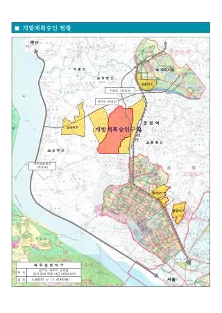
파주시청. 황 룡 산. 장 명 산. 심 학 산. 파 주 운 정 지 구. 위 치. 경기도 파주시 교하읍 당하 · 동패 · 목동 · 야당 · 와동리일원. 면 적. 4,692 천 ㎡ (1,419 천평 ). ■ 개발계획승인 현황. 문산. 곡 릉 천. 금촌지구. 국지도 56 호선. 운 정 역. 교하지구. 개발계획승인구역. 경 의 선. 국지도 23 호선 ( 자유로 ). 일산 2 지구. 풍동지구. 서울. 파주시청. 황 룡 산. 장 명 산. 심 학 산. 파 주 운 정 지 구.
Download
1 / 2
Télécharger la présentation 
경 의 선
An Image/Link below is provided (as is) to download presentation
Download Policy: Content on the Website is provided to you AS IS for your information and personal use and may not be sold / licensed / shared on other websites without getting consent from its author.
Content is provided to you AS IS for your information and personal use only.
Download presentation by click this link.
While downloading, if for some reason you are not able to download a presentation, the publisher may have deleted the file from their server.
During download, if you can't get a presentation, the file might be deleted by the publisher.
E N D
Presentation Transcript
파주시청 황 룡 산 장 명 산 심 학 산 파 주 운 정 지 구 위 치 경기도 파주시 교하읍 당하·동패·목동·야당·와동리일원 면 적 4,692천 ㎡ (1,419천평) ■ 개발계획승인 현황 문산 곡 릉 천 금촌지구 국지도 56호선 운 정 역 교하지구 개발계획승인구역 경 의 선 국지도23호선 (자유로) 일산2지구 풍동지구 서울
파주시청 황 룡 산 장 명 산 심 학 산 파 주 운 정 지 구 위 치 경기도 파주시 교하읍 당하·동패·목동·야당·와동리일원 면 적 4,692천 ㎡ (1,419천평) ■ 개발계획승인 현황 문산 곡 릉 천 금촌지구 국지도 56호선 운 정 역 교하지구 개발계획승인구역 경 의 선 국지도23호선 (자유로) 일산2지구 풍동지구 서울
More Related