Download
1 / 1
10 likes | 135 Vues
This report summarizes the recent MOPITT (Measurement Of Pollution In The Troposphere) data, focusing on CO mixing ratios at 700mb from January 1-3, 2001. It compares the capabilities of the V2 and V3 products, highlighting improvements in calibration and data coverage. The analysis presents CO total column amounts and addresses how these measurements correlate with biomass burning events in regions like Montana and North Dakota. Graphical data illustrates the differences in aerosol optical depth and CO emissions from fires, emphasizing the effectiveness of MOPITT in monitoring tropospheric pollution.

E N D
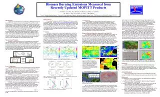
4 1 3 2 4 Alberta Saskatchewan Montana North Dakota Idaho a b (a) (b) 3 3 1 1 d c 2 2 Figure 2. CO mixing ratio at 700mb for Jan. 1-3, 2001 for MOPITT product V2 (a) and V3 (b). Equivalent Average & Difference Transmission Cell transmission I Average Transmission Cell transmission II Difference Transmission Biomass Burning Emissions Measured from Recently Updated MOPITT ProductsJ. X. Warner1, J.C. Gille1, D. P. Edwards1, M. Deeter1, D. Ziskin1, L. Emmons1, J. M. Feltz5, A. Chu4, E. M. Prins6, J-L. Attie3, J. Drummond21 National Center for Atmospheric Research 2 University of Toronto Department of Physics 3 Laboratoire d'Aerologie, Toulouse, France 4MODIS aerosol team, NASA GSFC, Greenbelt, MD, USA 5CIMSS, University of Wisconsin, Madison, Wisconsin, USA 6NOAA/NESDIS/ORA Advanced Satellite Products team, University of Wisconsin, Madison Wisconsin, USA Data Products: A "provisional" version of the MOPITT CO Retrievals (V3) is now available at the Langley DAAC. See http://www.eos.ucar.edu/mopitt/index.html/data for more information. MOPITT CO profiles and total column amount will be provided for the period of March, 2000 to April, 2001. The current processing will start at Nov., 2000 due to the availability of the MODIS cloud mask data. MOPITT encountered a cooler failure in May, 2001 that resulted the loss of half of MOPITT channels. Only CO mixing ratio maps in the higher troposphere will be provided after the anomaly (May, 2001 to current). V3 Upgrades: Calibration was improved to average ground sampling and to calculate the average and difference radiances. Approximately forty percent of global coverage was recovered from the previous versions when the first 2 stares (4 pixels per stare) in each 5 stare data package were eliminated due to uncertainties. The global CO coverage is also doubled due to the data usage over low cloud. In addition, by the application of MODIS cloud mask, the data over polar regions is extended to about 85 degree North and South. Figure 2 shows a comparison of data coverage between a pre-V3 version (V2) (a) and a provisional version of V3 (b) MOPITT CO total column amounts for Jan. 1 -3, 2001. A validation example of V3 products against aircraft measurements is shown in Figure 3 for CO mixing ratio at 6 vertical levels. and correlate very well with CO plumes from the same biomass burning source. In area 3, there is a very large area of high aerosol optical depth off the west coast of Africa and only relatively small area of elevated CO is correlated with the small mode aerosol. The elevated CO is due to the fires in Africa from TRMM fire products (not shown here). Evidently, a large portion of the aerosol off Africa is from dust storms indicated by large mode aerosols in figure 5c. In area 4, the aerosols observed off the east coast of the US are primarily due to automobile emission and industrial pollution as characterized by small mode particles. The elevated CO observed by MOPITT correlates well with this outflow. Another example of MOPITT measurement is from the Montana fire emission during Aug. 20, 2000 to Aug. 27, 2000. The CO total column is shown in Figure 7b for Aug. 22-24, 2000 and 7c for Aug. 25-27, 2000. Figure 7a shows the fire pixels detected by WF-ABBA during Aug. 20-27, 2000, and 7d shows the averaged 700hPa streamline analysis. The fire emission from Idaho and part of Montana was transported by the eastward wind to Montana and North Dakota. This case demonstrates that MOPITT is sensitive to those boreal fires that do not necessarily persist for a long time as in the cases over South America and Africa. Introduction: The Measurement Of Pollution In The Troposphere (MOPITT) instrument on board EOS Terra is designed to measure the tropospheric CO and CH4 at a nadir-viewing geometry. The measurements are taken at 4.7um in the thermal region, and 2.3um and 2.2um in the solar region for CO mixing ratio retrieval, CO total column amount and CH4 column amount retrieval, respectively. MOPITT has been collecting data for over two years and will be providing CO mixing ratio profiles and integrated total column amount for the period of March, 2000 to April, 2001. This poster briefly summarizes the MOPITT measurement principle, data processing algorithm, and currently available data products. MOPITT recently released V3 products are discussed and some example of the validation results are shown. A few examples of MOPITT measurements of biomass burning events are also shown and discussed. Elevated CO plumes are correlated with fire events from GOES WF_ABBA (The GOES Wildfire Automated Biomass Burning Algorithm) (Prins et al, 2001), and MODIS aerosols (Kaufman and Tanre, 1998). Measurement Principle: MOPITT CO and CH4 channels use Correlation Radiometry (Drummond, 1989) that modulates at a longer and a shorter cell path. An average (A) and a difference (D) transmission are calculated in each modulation. The A signals represent the background radiation and are used for cloud detection and to determine other surface properties, and the D signals represent the target gas absorption/ emission and are used for retrievals, as shown in Figure 1. The various channels use different cell pressures and their weighting function peak at different altitudes in the atmosphere and , hence, produce CO profile information. Averaging Kernels: The Averaging Kernelsrepresent the measurement sensitivity to the true profiles, as shown in Eq. 1,and depends on those factors affecting the radiative transfer of the measured signal through the atmosphere. An example of MOPITT averaging kernels is shown in Figure 4 for day (a) and night (b). As shown in (a) and (b), the averaging kernels peak at lower layers in the atmosphere during the day than at night for the same channels. Therefore, MOPITT day retrievals are slightly larger than night retrievals. Explicit consideration of the MOPITT averaging kernel is required to properly compare MOPITT data with trace gas profiles obtained from in-situ instrumentation or from chemistry model output. Biomass Burning Emissions Measured from MOPITT: An example plot of MOPITT CO mixing ratio at 700hpa is shown in Figure 5a for April 10, 2001 to April 17, 2001. The map covers the area of North and South America, Western Africa, and Atlantic Ocean. MOPITT data was retrieved using a precursor to the V3 processor that incorporated MODIS cloud mask data. Figure 5b shows the MODIS ocean and land aerosol optical depth retrieved from 0.55um wavelength over the same area and for April 7 to April 15, 2001. Figure 5c shows the MODIS small/large mode ratio for April 7 to April 15, 2001. Figure 6 shows a fire map from GOES-8 WFABBA for April 10-17, 2001 over Central America (left panel) and the AVN average 700hPa streamline analysis for April 12-19, 2001 (right panel). 4 b a Figure 7. a shows the WF-ABBA fire map over Montana fire, b is MOPITT total column for the early part of the fire, c is for the later part of the fire, and d shows the 700mb streamline analysis. Figure 5. a. MOPITT CO mixing ratio at 700hPa (4/10-17/2001), b. MODIS optical depth (4/7-15/2001), and c. MODIS Small/ Large Mode Ratio (4/7-15/01). Numbered boxes 1-4 are the borders for the areas of interests. 1. Yucatan Peninsula fire, 2. Venezuela fire, 3. Africa dust storm and fire, and 4. North America automobile emissions and industrial pollution. Summary: MOPITT provisional V3 products begin to be available at Langley DAAC. MOPITT CO measurement is sensitive to biomass burning emissions. Elevated MOPITT CO plumes correlate well with MODIS aerosols from the same source that are characterized as small mode aerosols. MOPITT products are essentially insensitive to large model aerosols from sources such as dust storms. Acknowledgement: The NASA Earth Observing System (EOS) Program funded this work under contract NAS5-30888. MODIS cloud mask and aerosol was provided by NASA DAAC. References: J. R. Drummond, “Novel correlation radiometer: the length-modulated radiometer,” Appl. Opt., 34, pp. 6976-6988, 1989 Y. J. Kaufman and D. Tanre, 1998: Algorithm for Remote Sensing of Tropospheric Aerosol from MODIS. MODIS ATBD E. M. Prins, J. Schmetz, L. Flynn, D. Hillger, J. Feltz, 2001: Overview of current and future diurnal active fire monitoring using a suite of international geo- stationary satellites. In Global and Regional Wildfire Monitoring: Current Status and Future Plans (F. J. Ahern, J. G. Goldammer, C. O. Justice, Eds.), SPB Academic Publishing, The Hague, Netherlands, pp. 145-170 J. X. Warner, J. C. Gille, D. P. Edwards, D. C. Ziskin, M. W. Smith, P. L. Bailey, L. Rokke, “Cloud Detection and Clearing for the Earth Observing System Terra Satellite Measurements of Pollution in the Troposphere (MOPITT) Experiment”, Applied Optics: Vol. 40, issue 8, 1269-1284, 2000 Figure 1: Correlation radiometry measurement principle. Level-2 Algorithm: After the Level 0-1 Processor has converted instrument counts into calibrated channel radiances, the Level 1-2 Processor retrieves the final geophysical CO and CH4 data products. In the Level-2 processor, the meteorological data and climatology are interpolated in time and space to match L1 observation. Then L1 data and the ancillary data are passed to the cloud detection and only the clear pixels are passed to the retrieval module. MOPITT latest version V3 processor uses a hybrid cloud detection method that incorporates MODIS cloud mask and MOPITT radiance (Warner et al., 2000). The clear pixels based on MODIS cloud mask are passed directly to the retrieval. Since MOPITT weighting functions peak at the mid- and high-troposphere, the radiances are less sensitive at lower atmosphere. MOPITT CO retrieval over very low cloud are recovered, and thus, the global CO coverage has been doubled. MOPITT retrieval uses a maximum likelihood method that incorporates our prior knowledge of the physical and statistical variability of the trace gas distribution in the atmosphere to choose the solution. The trace gas variability is expressed in the form of the a priori vertical profile and covariance matrix. The retrieved profile xret can then be expressed as a linear combination of the ‘true’ profile x and the a priori profile xa. c Figure 3. Validation of V3 CO mixing ratio (ppbv) against aircraft measurements at pressure levels of 850, 700, 500, 350, 250, and 150mb. Figure 6. GOES-8 WFABBA fire map for April 10-17, 2001 (left panel) and AVN 700hPa streamline Analysis for April 12-19, 2001. In Area 1 the elevated CO and aerosol concentrations over eastern Texas of US are believed to be due to fires over Yucatan Peninsula. The biomass burning emissions from Yucatan Peninsula traveled west and then north as shown by the 700hPa streamlines. In area 2, the elevated CO and aerosol over Venezuela and Columbia and off Columbia coast are transported from fires in Venezuela as shown in Figure 6 left panel. Aerosols emitted from biomass burnings are primarily small mode aerosols, Figure 4. MOPITT Averaging Kernels for daytime and nighttime. xret = Ax + (I - A)xa (Eq. 1) where the Averaging Kernel A represents the measurement sensitivity to the true profile.


