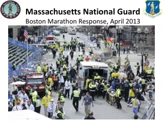
Boston Marathon
Boston Marathon. 2013. Air Operators. Matthew A. Leeser – Aviation Safety Inspector. March 13, 2013. OVERVIEW. Start Times Route Staging Area Review Boston Terminal Area chart Notams Safe Altitudes ATC coordination. Marathon Information . Start Times Mobility Impaired 9:00am

Boston Marathon
E N D
Presentation Transcript
Boston Marathon 2013 Air Operators Matthew A. Leeser – Aviation Safety Inspector March 13, 2013
OVERVIEW • Start Times • Route • Staging Area • Review Boston Terminal Area chart • Notams • Safe Altitudes • ATC coordination
Marathon Information Start Times • Mobility Impaired 9:00am • Wheelchair 9:17am • Handcycle 9:22am • Elite Woman 9:32am • Wave One(EliteMen) 10:00am • Wave Two 10:20am • Wave Three 10:40am
Staging Area • Boston VOR 112.7 / 268 radial @ 25 DME • Directly under V1-419 Airway • ½ way between BOSOX and WHYBE intersection
NOTAMS FDC NOTAM 5/9191 in effect for Red Sox game at Fenway Park • Game start time 11:05am • NOTAM in effect from 1hr before to 1hr after game • 3nm radius • Surface to 3000’agl • Waivers 571-227-2701 • HTTPS://WAIVER.C3.FAA.GOV
Military Jet Flyover NO FLYOVER THIS YEAR
Safe Altitudes • 14 CFR 91.119 • Open Air Assembly – 1000’ above highest obstacle within a 2000’ horizontal radius CAUTION: • Needham Towers – 1449’msl (1296’agl) • Tower ~½ mile south of start line – 1061’msl
Fenway TFR Needham Towers
FREQUENCYS • 124.725 “Skyways” • 122.85 Airplane Multicomm Coordination • 123.025 Helicopter Multicomm Coordination
Altitudes / Directions • Eastbound – South side of course • Westbound – North side of course
Altitudes / Directions • Helicopters RIGHT TURNS 900’MSL • News Helicopters RIGHT TURNS 2000’MSL • Airplanes (BANNER TOW)LEFT TURNS >1400’MSL • Helicopters at this altitude will also make LEFT TURNS