Download
1 / 19
210 likes | 427 Vues
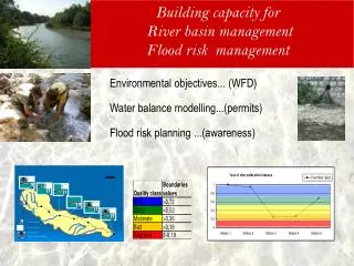
Building capacity for River basin management Flood risk management. Environmental objectives... (WFD) Water balance modelling...(permits) Flood risk planning ...(awareness). Pilot projects. Location of Pilot project. Groundwater body status Biology : surface water body

E N D
Building capacity for River basin managementFlood risk management Environmental objectives... (WFD) Water balance modelling...(permits) Flood risk planning ...(awareness)
Pilot projects Location of Pilot project Groundwater body status Biology : surface water body Water allocation : WEAP model Flood risk mapping Istok alluvial aquifer Peja 2008 – Prizren 2009 sub-basin Radoniqi area - Decani river basin Skenderaj flooding area Participants Activities in summer 2009 Water Department Hydro-Meteorological Inst. Pristina University Kosovo Env. Prot. Agency Muncipalities Irrigation Companies Measurement in 99 wells (piezometry, permeability) Water analyses ( 22 sampling) Biological sampling and analyses ( 3 sites) Electrofishing ( 3 sites) Irrigation looses, flow measurement, Estimhab method ( 3 sites) Topograhic survey, interview flooding zone
Sampling of macro invertebrates Electro-fishing Values of intercalibration index for 3 stations River Lumbhardi I prizrenit, 2009
Study tour at Nimes Measurement E-flow Equipment for high flow Trainees Use of information for flood risk warning
Measurements for E-flow calculation Flow stones measurements Use of the software Estimhab
Groundwater pilot project Measurement of the depth and of the permeability by slug test Calibration GPS In Klina Record on field forms of the measurements in Istog alluvial aquifer Analyse of results producing maps – training for replication
Project products for this reporting period
Web portal Pjt web site Result 1 : Main issues Information System Data base – GIS – web • Training on web portal, WD staff can download files and update it - Paul HAENER • Production of a data base and forms for recording monitoring data – Visar URUQI • Production of the web site for project visibility • Data acquisition through 4 pilot projects Data catalogue databases • Active web portal administrator required • to upload files, • to insure accessibility • to manage private/public access • The links and codification of database have to be improved, staff need to improve their level in Excel and database • Access to the project output is possible through password or registration. Who will give the right to the users after the end of the project ?
Result 2 : Main issues Monitoring system • Bidding Document for Drilling Contract (Annex 10) Malcolm ASHWORTH - Ground Water monitoring programme, resources needed (Annex 13) Jurgen DOMEROESE • MissionReport on WFD compatible biological classification (Annex 18) Antonin CARREY • -leadership for monitoring system improvement is needed • decision has to be taken on which institution will continue monitoring activities • organise light external assistance, ( several weeks per year). • Need of support for project implementation to check the proper application of methodologies
Result 3 : Modelling RB management Main issues • Other measurements are needed in high water conditions to calculate the E-flow; • The use of models has to be supported by external assistance; • - Concrete options of water management resulting from the modelling outputs to be discussed. • - Report on the pilot field work on the irrigation performance and • Environmental flow (E-flow). • (Annex 15) by Kujtim ZENA and Wilfried HUNDERTMARK • Preparation of mission for water demand and water balance methodologies and WEAP modelling ( October 2009) • Preparation for a Water management plan in the Pilot area Decani Radoniqi water system
ToR Water Supply and Sanitation Investment Plan Flood risk management Result 4 : Comments • Terms of reference Kosovo urban water supply and sanitation investment plan and credit facility • (Annex 9) Jan- David • MUELLER-VOLLMER • Topographic survey of the flooding zone of Skenderaj, compulsory for modelling risk sub-contracted, • quality control by JSTE • Ibrahim LEKAJ • Report delivered to ECLO taking into account comments form donors, • the first draft of the topographic survey was not sufficient, additional surveying was needed, • Modelling of flood risk is possible for October 2009
Result 5 : Institution and Legislation Main issues • Assessment of the different options for the establishment of the River Basin District Authorities (RBDA) • (Annex 11) Jacques SIRONNEAU • Analytic report on waterand other legislation related to water planning and administration • (Annex 12) by SelveteDEBIANI • clarification of the position of the MESP about RBDA establishment and development • process of writing a better water law and subsidiary acts (permit) to launch for better approximation of WFD and remove unnecessary details
Outputs / project ToR RBDA : River Basin District Authorities WD : Water Department WB : water bodies PP : Pilot project
Responsibilities and capacity for continuation How to raise project positive impact ? The project ends in January 2010, extension possible to February : How to efficiently use methods and tools ? How to replicate in other zones ? Use of computer tools ? How to insure sustainability ? Data catalogue, web portal Databases : WISKI, permits, monitoring, Water Bodies related data Modelling for Water Management (WEAP) Mapping methods for Flood risk Who is responsible for continuation ? Allocation of resources needed ? Skills required ( internal, external) ? Condition of employment ?
Planning Period Activities to complete • Flood risk mapping and flood risk plan • Hydrological study • Management Plan October Productions of manuals November • - Production of final report • - Work on Radoniqi management plan • Finalisation of technical reports and manuals • Work on database • Content of website and other visibility activities December Training and study tour
Extension up to end of February 2009 Objective : a) tobetter disseminate the project achievement b) to insure political support for continuation of activities Activities • Water conference in January • Municipalities events to present achievements • training on project identification and promotion • Additional technical training • Support in the process of law and subsidiary act writing • Visibility activities – editing of document, interview, documentary • (JSTE , journalist - event manager)