Download
1 / 64
660 likes | 1.06k Vues
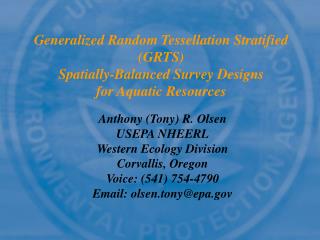
Generalized Random Tessellation Stratified (GRTS) Spatially-Balanced Survey Designs for Aquatic Resources. Anthony (Tony) R. Olsen USEPA NHEERL Western Ecology Division Corvallis, Oregon Voice: (541) 754-4790 Email: olsen.tony@epa.gov. Co-Developers. Tony Olsen, EPA WED

E N D
Generalized Random Tessellation Stratified (GRTS) Spatially-Balanced Survey Designs for Aquatic Resources Anthony (Tony) R. Olsen USEPA NHEERL Western Ecology Division Corvallis, Oregon Voice: (541) 754-4790 Email: olsen.tony@epa.gov
Co-Developers • Tony Olsen, EPA WED • Don Stevens, Oregon State U • Denis White, EPA WED • Tom Kincaid, Dynamac Corp • Christian Platt, Dynamac Corp • Richard Remington, EPA WED • Barbara Rosenbaum, INDUS Corporation • David Cassell, CSC • EMAP Surface Waters Research Group • Users: States, EPA Regions, & others
Overview • Aquatic resource characteristics • Sample frame • GIS coverages • Imperfect representation of target population • GRTS theory • GRTS implementation
Natural Resource Characteristics • Types of natural resources • Area polygons: large lakes and reservoirs, estuaries, coastal waters, everglades, forests, landscapes • Linear networks: streams, rivers, roads, trails • Discrete points: small lakes, stream reaches, prairie pothole wetlands, hydrologic units (“watersheds”), buildings • Target population • Finite in a bounded geographic region: collection of points • Continuous in a bounded geographic region • As linear network • As collection of polygonal areas • Generalizations • Geographic region may be 1-dimensional (p-dimensional) • “Space” may be defined by other auxiliary variables
Typical Aquatic Sample Frames • GIS coverages do exist for aquatic resources • National Hydrography Dataset (NHD) • Based on 1:100,000 USGS maps • Combination of USGS Digital Line Graph (DLG) data set and USEPA River Reach File Version 3 (RF3) • Includes lakes, ponds, streams, rivers • Sample frames derived from NHD • Use GIS to extract frame to match target population • Enhance NHD with other attributes used in survey design • Issues with NHD • Known to include features not of interest (over-coverage) • Known to exclude some aquatic resources (under-coverage)
Other Natural Resource Frames • Omernik ecoregions digital maps • National Wetland Inventory (NWI) digital maps • Landcover/landuse digital maps
Generalized Random Tessellation Stratified (GRTS) Survey Designs • Probability sample producing design-based estimators and variance estimators • Gives another option to simple random sample and systematic sample designs • Simple random samples tend to “clump” • Systematic samples difficult to implement for aquatic resources and do not have design-based variance estimator • Emphasize spatial-balance • Every replication of the sample exhibits a spatial density pattern that closely mimics the spatial density pattern of the resource
GRTS Implementation Steps • Concept of selecting a probability sample from a sampling line for the resource • Create a hierarchical grid with hierarchical addressing • Randomize hierarchical addresses • Construct sampling line using randomized hierarchical addresses • Select a systematic sample with a random start from sampling line • Place sample in reverse hierarchical address order
Create Straight LineAll Reaches 3 0 2 1 0 1 2 3 Create Line for Ohio River (length) Divide into 4 segments Create Random Sequence (3, 0, 2, 1) Assign address & color Sort address Repeat for each segment
00 01 02 03 10 11 12 13 20 21 22 23 30 31 32 33 Repeating Process 0 1 2 3 02 00 03 01 11 12 10 13 20 23 21 22 32 33 31 30 Divide each segment into 4 segments Create New Random Sequences (2,0,3,1) (1,2,0,3) (0,3,1,2) (2,3,1,0) Assign address & colors Sort
1 2 3 4 5 6 7 8 9 10 11 12 13 14 15 16 Selecting 16 Sample Points Subdivide, Create Random Sequence, Assign Address & Colors Sort Addresses Random Starting point, Uniformly Sample Line Assign Sequence Number to Each Point
Original Order 1 2 3 4 5 6 7 8 9 10 11 12 13 14 15 16 Base4 00 01 02 03 10 11 12 13 20 21 22 23 30 31 32 33 Sort 10 31 00 01 02 03 11 12 13 20 21 22 23 30 32 33 Reverse Base4 00 10 20 30 01 11 21 31 02 12 22 32 03 13 23 33 1 2 3 4 5 6 7 8 9 10 11 12 13 14 15 16 Reverse Hierarchical Order RHO Site Number Create Base4 Addresses Reverse Address Digits Sort Assign RHO Site Nos.
RHO 1 2 3 4 5 6 7 8 9 10 11 12 13 14 15 16 Map Sites Original Line (unsorted) 11 3 12 9 8 4 1 7 5 10 2 6
Ohio River Sites 2 6 3 10 5 11 1 4 7 9 8 12
Selecting a Probability Sample from a Sampling Line: Linear Network Case • Place all stream segments in frame on a linear line • Preserve segment length • Identify segments by ID • In what order do place segments on line? • Randomly • Systematically (minimal spanning tree) • Randomized hierarchical grid • Systematic sample with random start • k=L/n, L=length of line, n=sample size • Random start d between [0,k) • Sample: d + (i-1)*k for i=1,…,n
Selecting a Probability Sample from a Sampling Line: Point and Area Cases • Point Case: • Identify all points in frame • Assign each point unit length • Place on sample line • Area Case: • Create grid covering region of interest • Generate random points within each grid cell • Keep random points within resource (A) • Assign each point unit length • Place on sample line
Randomized Hierarchical Grid Step 1 Step 2 Step 3 Step 4 • Step 1: Frame: Large lakes: blue; Small lakes: pink; Randomly place grid over the region • Step 2: Sub-divide region and randomly assign numbers to sub-regions • Step 3: Sub-divide sub-regions; randomly assign numbers independently to each new sub-region; create hierarchical address. Continue sub-dividing until only one lake per cell. • Step 4: Identify each lake with cell address; assign each lake length 1; place lakes on line in numerical cell address order.
Hierarchical Grid Addressing 213: hierarchical address
Reverse Hierarchical Order • Construct reverse hierarchical order • Order the sites from 1 to n • Create base 4 address for numbers • Reverse base 4 address • Sort by reverse base 4 address • Renumber sites in RHO • Why use reverse hierarchical order? • Results in any contiguous set of sample sites being spatially-balanced • Consequence: can begin at the beginning of list and continue using sites until have required number of sites sampled in field
Unequal Probability of Selection • Assume want large lakes to be twice as likely to be selected as small lakes • Instead of giving all lakes same unit length, give large lakes twice unit length of small lakes • To select 5 sites divide line length by 5 (11/5 units); randomly select a starting point within first interval; select 4 additional sites at intervals of 11/5 units • Same process is used for points and areas (using random points in area)
Complex Survey Designs based on GRTS • Stratified GRTS: apply GRTS to each stratum • Unequal probability GRTS: adjust unit length based on auxiliary information (eg lake area, strahler order, basin, ecoregion) • Oversample GRTS: • Design calls for n sites; some expected non-target, landowner denial, etc; select additional sites to guarantee n field sampled • Apply GRTS for sample size 2n; place sites in RHO; use sites in RHO • Panels for surveys over time • Nested subsampling • Two-stage sampling using GRTS at each stage • Example: Select USGS 4th field Hucs; then stream sites within Hucs