Download
1 / 22
220 likes | 361 Vues
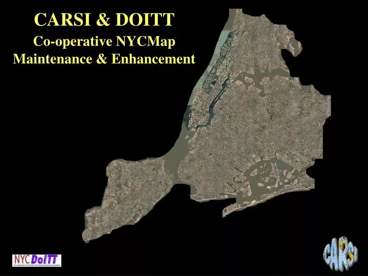
CARSI & DOITT Co-operative NYCMap Maintenance & Enhancement. Products and Application Development. Incremental Updates BIN Project Creation of NYC DEM. NYCMap Specifications. 2001-02 update enhanced 0.75 feet orthophotography true orthophotos for Manhattan

E N D
CARSI& DOITT Co-operative NYCMapMaintenance & Enhancement
Products and Application Development • Incremental Updates • BIN Project • Creation of NYC DEM
NYCMap Specifications • 2001-02 update enhanced • 0.75 feet orthophotography • true orthophotos for Manhattan • 3-D model of every building in Manhattan and every block in other boroughs with a building >= 7 stories • New Features: • billboards, park paths, ballfields, pools, etc.
NYCMap Creation and Update: “the Old Way” Hard Copy Maps CARSI Inspect for correctness Hard Copy Maps with Corrections Send corrections to Sanborn as hard copy. Repeat process 2-3 times until correct. Send to Sanborn as hard copy Sanborn Re-check Geometric accuracy Positional correctness Correct Updated Hard Copy Maps Export to CARSI Updated Base Map Process repeats for each of the 1,900 tiles in base map.
Updating the NYCMap from 1996 to 2001-2 :the New Way • Incremental Updating Process • Capture new objects, deleted objects and update objects photogrammetrically • Bring in QC objects for review • compare with new orthophotography • test against changes registered by DOB and DDC • accept or reject QC objects • accept - system updated automatically • Validation of accepted QC object
NYCMap Incremental Updates and Database Integration Insert VALIDATION Geometric Topology Attribute Consistency Changed Objects CARSI QA Objects UPDATED NYCMap Update Detect changes Generic ASCII Apply to database Correct Inspect Changes Accept Changes Delete Sanborn Re-check Reject Changes SANBORN Photo Update Sanborn Process Film Development Supply of GPS Data Aerial Survey Kinematic GPS Inertial Navigation Unit Bundle Adjustment Stereo-model Import old basemap Scanning Control Points Detect changes Compilation Capture changes Orthophoto Generic ASCII CARSI QC Objects Analog and/or digital output
NYCMap Incremental Updates and Database Integration Insert VALIDATION Geometric Topology Attribute Consistency SANBORN Photo Update Changed Objects CARSI QA Objects UPDATED NYCMap Update Detect changes Generic ASCII Apply to database Correct Inspect Changes Accept Changes Delete Sanborn Re-check Reject Changes Sanborn Process Film Development Supply of GPS Data Aerial Survey Kinematic GPS Inertial Navigation Unit Bundle Adjustment Stereo-model Import old basemap Scanning Control Points Detect changes Compilation Capture changes Orthophoto Generic ASCII CARSI QC Objects Analog and/or digital output
NYCMap Incremental Updates and Database Integration Insert VALIDATION Geometric Topology Attribute Consistency SANBORN Photo Update Changed Objects CARSI QA Objects UPDATED NYCMap Update Detect changes Generic ASCII Apply to database Correct Inspect Changes Accept Changes Delete Sanborn Re-check Reject Changes Tile # 30056 Base Map QC/QA objects: • Approximately 320 tiles (2000m.sq.) • Average number of QA objects per tile: 700 Insert Update Delete
NYCMap Incremental Updates and Database Integration Insert VALIDATION Geometric Topology Attribute Consistency SANBORN Photo Update Changed Objects CARSI QA Objects UPDATED NYCMap Update Detect changes Generic ASCII Apply to database Correct Inspect Changes Accept Changes Delete Sanborn Re-check Reject Changes Base Map: 1996 Ortho-photography and planimetric data
NYCMap Incremental Updates and Database Integration Insert VALIDATION Geometric Topology Attribute Consistency SANBORN Photo Update Changed Objects CARSI QA Objects UPDATED NYCMap Update Detect changes Generic ASCII Apply to database Correct Inspect Changes Accept Changes Delete Sanborn Re-check Reject Changes Base Map: 2001 Ortho-photography and planimetric data
NYCMap Incremental Updates and Database Integration Insert VALIDATION Geometric Topology Attribute Consistency SANBORN Photo Update Changed Objects CARSI QA Objects UPDATED NYCMap Update Detect changes Generic ASCII Apply to database Correct Inspect Changes Accept Changes Delete Sanborn Re-check Reject Changes Base Map: 2001 Ortho-photography and planimetric data QC/QA Objects
NYCMap Incremental Updates and Database Integration Insert VALIDATION Geometric Topology Attribute Consistency SANBORN Photo Update Changed Objects CARSI QA Objects UPDATED NYCMap Update Detect changes Generic ASCII Apply to database Correct Inspect Changes Accept Changes Delete Sanborn Re-check Reject Changes Base Map: 2001 Ortho-photography and planimetric data QC/QA Objects 2001 Updated Base Map
NYCMap Incremental Updates and Database Integration Insert VALIDATION Geometric Topology Attribute Consistency SANBORN Photo Update Changed Objects CARSI QA Objects UPDATED NYCMap Update Detect changes Generic ASCII Apply to database Correct Inspect Changes Accept Changes Delete Sanborn Re-check Reject Changes Buildings After accepting changes Before accepting changes
NYCMap Incremental Updates and Database Integration Insert VALIDATION Geometric Topology Attribute Consistency SANBORN Photo Update Changed Objects CARSI QA Objects UPDATED NYCMap Update Detect changes Generic ASCII Apply to database Correct Inspect Changes Accept Changes Delete Sanborn Re-check Reject Changes Buildings Changed After accepting changes Before accepting changes
NYCMap Incremental Updates and Database Integration Insert VALIDATION Geometric Topology Attribute Consistency SANBORN Photo Update Changed Objects CARSI QA Objects UPDATED NYCMap Update Detect changes Generic ASCII Apply to database Correct Inspect Changes Accept Changes Delete Sanborn Re-check Reject Changes Buildings Deleted After accepting changes Before accepting changes
NYCMap Incremental Updates and Database Integration Insert VALIDATION Geometric Topology Attribute Consistency SANBORN Photo Update Changed Objects CARSI QA Objects UPDATED NYCMap Update Detect changes Generic ASCII Apply to database Correct Inspect Changes Accept Changes Delete Sanborn Re-check Reject Changes Rejected QC Object for new building New building’s polygon overlaps existing building
NYCMap Incremental Updates and Database Integration Insert VALIDATION Geometric Topology Attribute Consistency SANBORN Photo Update Changed Objects CARSI QA Objects UPDATED NYCMap Update Detect changes Generic ASCII Apply to database Correct Inspect Changes Accept Changes Delete Sanborn Re-check Reject Changes Missed feature Capture geometry and position QC rejected object Send to Sanborn as Generic ASCII Sanborn Re-check Geometric accuracy Positional correctness Correct Changed Objects Send to CARSI as Generic ASCII CARSI QC Objects Features overlooked by Sanborn
NYCMap Incremental Updates and Database Integration Insert VALIDATION Geometric Topology Attribute Consistency SANBORN Photo Update Changed Objects CARSI QA Objects UPDATED NYCMap Update Detect changes Generic ASCII Apply to database Correct Inspect Changes Accept Changes Delete Sanborn Re-check Reject Changes • GEOMETRY • Buildings • Internals - completely surrounded/bordered by buildings? • Faces - bordered by exactly one building polygon? • Edges • Must be building internal if shared by two or more buildings • Must be building face if not shared with another building • Slivers – report all buildings smaller then 5 square feet • Street Centerlines • Street-centreline – feature overlap • Intersection of hidden street-centreline with visible street-centreline • Visible street centerline may continue onto hidden segment with same name. • Not connected street-centrelines • Street-centerlines that end at something other than a dead-end or street intersection (3 or more street centerlines). • ATTRIBUTES • Railroad • Name inconsistencies along connected railroad lines • Street Centerlines • Street-centreline – LION file: report any inconsistent street names based on LION
NYCMap Incremental Updates and Database Integration Insert VALIDATION Geometric Topology Attribute Consistency SANBORN Photo Update Changed Objects CARSI QA Objects UPDATED NYCMap Update Detect changes Generic ASCII Apply to database Correct Inspect Changes Accept Changes Delete Sanborn Re-check Reject Changes Accepted QA/QC objects Rejected QA/QC objects Base Map 2003 • Approximately 320 tiles (2000m.sq.) • Average number of QA objects per tile: 700 • Average number of rejected QA objects per tile: 30 • Estimated number of changes: 224,000 Map Legend
NYCMap Incremental Updates and Database Integration Insert VALIDATION Geometric Topology Attribute Consistency SANBORN Photo Update Changed Objects CARSI QA Objects UPDATED NYCMap Update Detect changes Generic ASCII Apply to database Correct Inspect Changes Accept Changes Delete Sanborn Re-check Reject Changes • Buildings • Building Component, Building Internal • Open Spaces • Transportation • Curbs • Street centerlines • Railroads • Transportation Structures • Bridge, Tunnel, Railroad Viaduct • Utility • Tank, Tower, Antenna • Billboard-Toll • Topography • Spot Elevations, Contour Lines • Hydrography • Hydro centrelines • Hydro features • Lake, Reservoir, Pond, Wetland. Beach, Bay • Hydro Structures • Pier, Jetty, Seawall Cemetery, Recreation Areas, Ball Fields, Pools, Hard Surface Courts, Skating Rings, Playgrounds, Parking lots. Bike Pedestrian Path, Unpaved trails in parks Unpaved Trails in Parks Power Plant Substation
NYCMap Incremental Updates and Database Integration Insert VALIDATION Geometric Topology Attribute Consistency SANBORN Photo Update Changed Objects CARSI QA Objects UPDATED NYCMap Update Detect changes Generic ASCII Apply to database Correct Inspect Changes Accept Changes Delete Propagate Changes Sanborn Re-check NYCMap Users Reject Changes Propagation of Base Map Changes to City Agencies Base Map: 1996 Checkpoint: 10/10/1996 11:12:07 Detect Changes Base Map: 2003 Checkpoint: 9/24/2003 13:11:09 Objects: 37,812 Export changes as ASCII Base Map: Changes Checkpoint: 9/24/2003 13:11:09 Objects: 704
Incremental Updates: “the New Way” Implications of Incremental Updates Application • Save Money • Save Time • Incremental Updates • Improve Data Quality