Download
1 / 22
220 likes | 393 Vues
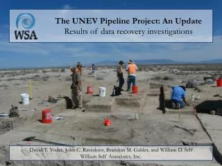
The UNEV Pipeline Project: An Update Results of data recovery investigations. David T. Yoder, John C. Ravesloot, Brandon M. Gabler, and William D. Self William Self Associates, Inc.

E N D
The UNEV Pipeline Project: An Update Results of data recovery investigations David T. Yoder, John C. Ravesloot, Brandon M. Gabler, and William D. Self William Self Associates, Inc.
In 2010 the Holly Corporation is scheduled to construct the UNEV pipeline, a 400-mile-long project that will carry liquid petroleum products from a refinery in Woods Cross in north Salt Lake City to northeast Las Vegas. In 2009, as part of the mitigation effort for UNEV, William Self Associates performed phased data recovery at 11 prehistoric and 4 historic sites along the pipeline’s route. The preliminary results from two of the more interesting prehistoric sites (42MD3014 and 42MD3285, both near Delta, Utah) are presented. A human behavioral ecology framework is used to investigate issues related to site use and occupation.
UNEV Research Themes • Hypothesis 1: Archaic groups practiced a high degree of residential mobility • Hypothesis 2: Formative groups practiced a low degree of residential mobility • Hypothesis 3: Late Prehistoric groups practiced a high degree of residential mobility • Hypothesis 4: According to Madsen and Simms (1998), Fremont groups both farmed and foraged full-time, and switched between these strategies • Expectations: • Elements of Fremont material culture associated with characteristics of both high and low residential mobility should be present • Multiple types of Fremont complex sites should be present - some indicating long-term occupations associated with cultigens, others indicating foraging occupations • Material culture should provide indications of connections between foragers and farmers during the Formative period • Hypothesis 5: Wetlands environments were particularly productive, and therefore groups resided near them throughout prehistory
42MD3014: Class III Results • Site type: Artifact scatter - flaked stone • Culture and period: Archaic, Formative, Late Prehistoric • Diagnostic artifacts: One Gatecliff Contracting-stem point • Description • situated on low sand knoll on a flat plain, 2 miles north of Sevier River • moderate-density lithic scatter of 50 flakes, represents core reduction • 10 obsidian specimens collected for sourcing and hydration analyses • 8 from Black Rock, 1 from Topaz Mountain, 1 from Wild Horse Canyon • hydration rims suggest Archaic, Formative, and Late Prehistoric periods Overview of site, view to the east
42MD3014: Subsurface Feature 1: Large basin-shaped depression Feature 2: Medium basin-shaped depression Feature 3: Brush structure or wikiup Feature 4: Medium pit Feature 5: Medium pit
42MD3014 Medium depression (Feature 2) post-excavation; view to the south
42MD3014 Wikiup (Feature 3) pre-excavation; view to the north
42MD3014 Wikiup (Feature 3) post-excavation; view to the east
42MD3014 Medium pit (Feature 4) post-excavation; view to the south and down
42MD3014 Medium pit (Feature 5) pre-excavation; view to the west and down
42MD3014 Summary • 42MD3014 represents a moderate- to high-density, multicomponent habitation site • surface assemblage • 626 artifacts: debitage, cores, bifaces, ceramics, and an Elko Corner-notched point • disturbed subsurface assemblage • 1,723 artifacts: debitage, bifaces, projectile points, ground stone, ceramics, faunal bone, a hammerstone, a stone bead, and a piece of shell • two pit features, two depressions, and a possible wikiup • three features (Features 2, 3, 4) have clustering 14C dates • wikiup absolute date (Cal A.D. 980 to 1060) is during the Formative/Fremont period • wikiup represents short-term habitation • flaked stone tool manufacture occurred • food processing, evidenced by: • ground stone • faunal bone (cottontails, jackrabbits, small mammals, duck, and common teal) • macrobotanical remains (pickleweed, cheno-am, bullrush, sunflower, dropseed, little barley grass, Indian rice grass, saltbush fruit)
42MD3285: Class III Results • Site Type: Artifact scatter - flaked stone, ceramics, FCR • Culture and Period: Fremont • Diagnostic Artifacts: Fremont Sevier Gray • Description • situated on broad, flat alluvial plain or terrace, one mile south of the Old River Bed • extensive, diffuse artifact scatter • 500+ Fremont Sevier Gray sherds visible on surface Overview of site, view to the north
Feature 1: FCR concentration Feature 2: Artifact concentration Feature 3: FCR concentration Feature 4: FCR concentration Feature 5: Basin-shaped depression, possible wikiup Feature 7: FCR and ground stone concentration Not shown: Feature 6, a natural soil stain 42MD3285: Subsurface
42MD3285 FCR concentration (Feature 1); view to the northeast
42MD3285 Possible wikiup (Feature 5) post-excavation, moistened for emphasis; view to the northwest
42MD3285 Summary • 42MD3285 represents a low- to moderate-density artifact scatter and possible habitation site • surface assemblage • 498 artifacts: debitage, a uniface, bifaces, and Sevier Gray and Snake Valley Gray ceramics • multiple FCR and artifact concentrations • disturbed subsurface assemblage • 277 artifacts: debitage, a hammerstone, a uniface, a biface, a Parowan Basal-notched point, ground stone, Sevier Gray ceramics, faunal bone, and a manuport • a possible wikiup • absolute date of Cal A.D. 450 to 450, 460 to 480, 530 to 640 • if a wikiup, it represents short-term habitation • food processing, evidenced by: • ground stone • faunal bone (a rodent) • macrobotanical remains (pickleweed, cheno-am, bullrush, Indian rice grass)
Conclusions • Data gathered during Phase I data recovery from 15 sites are most useful for: • contributing to knowledge of regional prehistoric occupation in Utah • addressing research questions posed earlier in this presentation directed towards local and regional mobility and settlement patterns • addressing some site-specific mobility questions • Primary field work ended in October • analysis of the large collection of artifacts and samples is in progress • for example, preliminary analyses of the materials from 42MD3014 and 42MD3285 suggest that: • lithic tool manufacture occurred, with little on-site core reduction • there were multiple occupations, minimally during the Archaic and Formative/Fremont periods
Conclusions • Many of the prehistoric sites failed to produce a lot of data, but: • negative data are data nonetheless, and • some of our historic sites are quite interesting, such as 42SL255, the subject of the next paper by Scott O'Mack • Thanks to Holly Energy Partners and Sinclair Oil Corporation for providing the means to collect and disseminate this information, and the agency archaeologists who helped to facilitate it.