Download
1 / 22
220 likes | 258 Vues
Explore marine sediment cores, identify components and origins, make smear slides, predict sediment lithologies, and analyze distribution patterns using real data in a pedagogical approach. Learn how to record observations systematically and classify sediments based on composition.

E N D
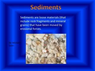
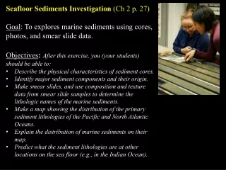
Seafloor Sediments Investigation (Ch 2 p. 27) • Goal: To explores marine sediments using cores, photos, and smear slide data. • Objectives:After this exercise, you (your students) should be able to: • Describe the physical characteristics of sediment cores. • Identify major sediment components and their origin. • Make smear slides, and use composition and texture data from smear slide samples to determine the lithologic names of the marine sediments. • Make a map showing the distribution of the primary sediment lithologies of the Pacific and North Atlantic Oceans. • Explain the distribution of marine sediments on their map. • Predict what the sediment lithologies are at other locations on the sea floor (e.g., in the Indian Ocean).
Pedagogy • Student Inquiry • Real Data • Constructivist approach do-talk-do-talk-do…. To Do: form teams
p. 27 Part 2.1. Predict (individually and then in your team): 1. What kinds of materials might you expect to find on the seafloor?2. Is there any geographic pattern to the distribution of these materials? You will investigate these questions using empirical data and teamwork. And then hypothesize why the sediments are distributed the way they are. Goal for you to learn both WHAT we know about seafloor sediments and HOW we know it.
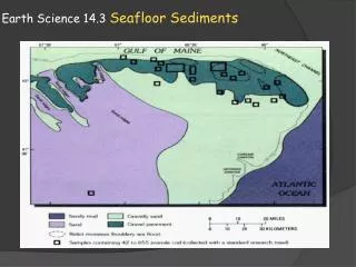
p. 28-33 Initial Inquiry into Seafloor Sediments: Core Observation Part 2.2 Q1: Find your team’s assigned cores in: • Core Photos (p.60-79; or access high resolution photos at: http://iodp.tamu.edu/database/coreimages.html) • Table 2.1 (p. 28-29) • On the base map (p. 32-33). Make a list of observations and questions. [Follow with whole group discussion.]
Assigning Unique Identification Codes to Scientific Samples Scientific ocean drilling site locations, from: http://iodp.tamu.edu/scienceops/maps.html
Example of sample nomenclature and core photo. The standard labeling for ocean drilling samples. From ODP Leg [i.e., Expedition] 199 Initial Reports Volume, Explanatory Notes: http://www-odp.tamu.edu/publications/199_IR/chap_02/chap_02.htm)
TO DO in your group: Q2 (p.30): Design a way to organize and record your visual observations that could be used by all of the students in the class for all of the cores. [Follow with whole group discussion.] Q3 (p. 31): Using the agreed upon approach, describe your core. [Follow with group presentations of cores.] Q4 (p. 34): Explain why a systematic, complete, and consistent method of recording observations is important.
p. 35-51 Sediment Composition (think back to your predictions) TO DO: Part 2.3 Q1 (p. 37): Match smear slide data for your core’s samples listed Table 2.2 (p. 42-51) to mineral and fossil images in Fig 2.3. • Composition (minerals & microfossils) and texture are the primary data used to “name” the sediment: • Extension Lab: Make a sample request from IODP (http://iodp.tamu.edu/curation/samples.html) and make your own smear slides. Try to identify the components, using the following resources: • Images in Fig 2.3, p. 35-36. • http://www.noc.soton.ac.uk/gg/BOSCORF/curatorial/grain_id.html • Rothwell, Minerals and Mineraloids in the Marine Sediments.
Sediment Classification….Name that Sediment! TO DO: Q2, (p. 37) For your assigned core(s), determine the dominant sediment types in the samples. HOW? • Use the smear slide data (Table 2.2, p. 42-51). • Look at the core photos p. 60-79, or access high res digital core photos at http://iodp.tamu.edu/database/coreimages.html) • Use the Decision Tree p. 38-41. • Record your sediment names in Table 2.2 AND (Part 2.4, Q1, p. 52) plot on your map AND on “class” map using colors on p. 52. Do example together
Important information about using the Decision Tree (p.38-41): The decision tree aims to capture the most distinctive (i.e., end-member, dominant) sediment types: • Calcareous ooze: biogenic sediments composed of calcareous nannofossils and/or foraminifers. • Siliceous ooze:biogenic sediments composed of diatoms, radiolarians, sponge spicules, and/or silicoflagellates. • Red clays: very fine terrigenous sediment that often contains siliceous microfossils, fish teeth, Mn-Fe micronodules, and/or volcanic glass. • Terrigenous sediment: siliclastics; sediment from the weathering of continents or volcanic islands. • Glaciomarine sediment: sediment containing terrigenous sand, pebbles, or cobbles transported to the sea by icebergs. Note, while the above 5 sediment types are the most distinctive sediment types, mixed sediment types are common. In addition, the sediment type can also change within a core. For example the sediment could alternate between two or more sediment types or gradually change from one to another. In any of the sediment types, but especially in biogenic oozes and deep sea red clays, layers of volcanic ashmay be distinguishable.
TO DO: Q2 & Q3 (p. 52-54). Analyze class map. Develop hypotheses for what controls the distribution of each of the primary sediment types in the modern ocean.
How does this distribution compare to your initial predictions?
Distribution of Marine Sediments– there is a rhyme and reason! YOU derived this sediment type map from core data! Q4 (p.54): How does your map compare to this one? Distribution of the primary sediment types on the seafloor (from Davies and Gorsline, 1976; Rothwell, 1989)
Idea for extension: Interpret the rest of map (draw boundaries between different primary sediment types)
Follow-Up Exercise with Lecture on Marine Sediments Terrigenous Sediment Glaciomarine Sediment Terrigenous – but a special type that indicate glacial conditions on land. Can accumulate far from land via iceberg rafting. Best recognized by dropstones in cores. • derived from the weathering & erosion of rocks on land: sand & mud • accumulates along continental margins • masks other sediment types because of high sedimentation rates
Biogenic Rich Sediment = Ooze What are the requirements for biogenic ooze to accumulate ? 1. Productivity in the surface waters 2. Preservation (i.e., not dissolved) as settle through the water column 3. High relative abundance (i.e., avoid dilution by other sediment types)
Key points for Lecture on Marine Sediments Calcareous Ooze Siliceous Ooze composed of the siliceous shells of plankton (SiO2) accumulates under areas of high productivity • composed of carbonate shells of plankton(CaCO3) • accumulates on bathymetric highs (above CCD) & beyond the continental margins
Follow-Up Exercise with Lecture on Marine Sediments Deep Sea Red Clay • wind-blown dust & current transported clays • accumulates on the abyssal plains (deep broad sea floor) • mixed with minerals that precipitate on the sea floor and some siliceous microfossils • very slow sedimentation rates
Exploring Further: Q5b (p. 55): Is calcareous ooze in the N Atlantic found at the same depth, shallower depths, or deeper depths than in the N. Pacific? Why? Q6 (p. 55): The map you constructed represents the modern distribution of sediment types in the Pacific Ocean. Do you think this map would also represent sediment type distribution in the geologic past and in the geologic future?What factors might vary (in the past and in the future) that could change the distribution of sediment types?
See handout for most of the instructor guide; For full guide go to DROPBOX. • Exploring The Instructor Guide
Exploring Scientific Data Collected from Marine Expeditions • To Do: See Scientific Ocean Drilling Initial Results Volume(s) (online: http://www.iodp.org/scientific-publications/ or get a hard copy). Explore Initial Results Vol overall. • Idea for extension: Write (type, single spaced) a 1-page summary of the types of scientific data collected from cores, how it is reported and organized, and your comments and questions on it.
Ideas for Extension: Refine Your Core Description and Sediment Classification • Refine based on Explanatory Notes section of an Initial Results (IR) volume: • methodologies and symbols used in descriptions • http://publications.iodp.org/proceedings/320_321/102/102_f8.htm • http://publications.iodp.org/proceedings/320_321/102/102_3.htm • lithostratigraphy: naming the sediments (and then defining lithostratigraphic units) • http://publications.iodp.org/proceedings/320_321/102/102_f9.htm • Find the core description online (IR volumes) for your core. Compare your core description to the published description. Write a reflection on: the strengths and weakness of your description, how you would modify your approach in the future.