MODIS Ocean Data Workshop
MODIS Ocean Data Workshop. Introduction and MODIS History. LaSells Stewart Center. OSU Campus. Valley Library. A Short History. 1983 – NASA began to explore the concept of a polar-orbiting platform to complement a manned polar-orbiting space station

MODIS Ocean Data Workshop
E N D
Presentation Transcript
MODIS Ocean Data Workshop Introduction and MODIS History
A Short History • 1983 – NASA began to explore the concept of a polar-orbiting platform to complement a manned polar-orbiting space station • Beginning as System Z, gained momentum with NASA’s proposed “Global Habitability” program • After Challenger disaster, polar space station disappeared as did manned servicing requirement • System Z became EOS – Earth Observing System • Several instrument suites were developed • Surface Imaging and Sounding Package (SISP) included the Moderate Resolution Imaging Spectrometer • MODIS soon split into 2 concepts • MODIS-N focused primarily on land and atmosphere sensing but included some ocean bands • MODIS-T (tilting) focused on ocean • Because of budget constraints, MODIS-T vanished, replaced by MODIS-N and EOS-Color (to follow SeaWiFS) • Further budget reductions led to replacement of EOS-Color by SIMBIOS
Some Obscure Facts • MODIS was always viewed as the keystone sensor for EOS • Three pairs of MODII were planned initially to provide a 15-year time series • NOAA was involved for much of the development of EOS • Budget constraints and orbit incompatibilities led to eventual decoupling of NASA and NOAA • NASA always expected that NOAA would eventually assume responsibility for MODIS-like measurements
INTRODUCTION -MODIS OCEAN DATA PRODUCTS WORKSHOP Wayne E. Esaias GSFC Code 971 - Oceans and Ice Branch wayne.e.esaias@nasa.gov http://modis-ocean.gsfc.nasa.gov September 4, 2003 Oregon State University
Early EOS Approach • Obtain 15-20 Year Consistent Time Series • Upgrade to New Technology • Transition Research Mission to Quasi Operational System Centralized Data System COTS approach Active Archive Center (DAAC) System • Ongoing Instrument Team Responsibility Instrument performance linkages to science product performance • Transition to a truly operational climate system
Brief MODIS History • Definition Panel 1984 • Selection of Instrument, Instrument Team - 1989 • Restructuring - 1992 • MODIS-T out, PM MODIS-N in (6 MODIS-N’s) • Major budget reduction - 1997 • Addition of team member investigations • EOSDIS rescope • 6 platforms reduced to 1st 2 - AM-1, PM-1 • LaunchTerra 12/1999 • Launch Aqua 5/2002 • Re-compete in mid 2003
Instrument Overview • The MODerate Resolution Imaging Spectroradiometer (MODIS), one of the key instruments for NASA’s Earth Observing System (EOS), was built by Raytheon Santa Barbara Remote Sensing (SBRS) • MODIS ProtoFlight Model (PFM) was launched on board Terra spacecraft on 12/18/99 (first light on 02/24/00). • http://terra.nasa.gov/ • MODIS Flight Model 1 (FM1) on Aqua spacecraft was launched on 05/04/02 (first light on 06/24/02) • http://eos-pm.gsfc.nasa.gov/ • 20 Reflective Solar Bands (RSB): 0.4 - 2.2 microns • 16 Thermal Emissive Bands (TEB) 3.5 - 14.5 microns Page 10
MODIS Chronology MODIS Instrument Panel formed - 1984 Instrument Panel Report (MODIS N & T) – 1986 Phase-B Studies (N & T) complete – 1989 MODIS Science Team selected - 1989 MODIS-T CDR - 1990 MODIS-N Contract Award to SBRC – 1991 EOS program restructured - 1992 EOSDIS restructured - 1996 Protoflight Model shipped – 1997 EOS Terra launched – 12/18/99 EOS Aqua launched 05/04/2002 Page 11
MODIS Instrument DefinitionTeam • * Wayne Esaias (Chairman) NASA Hq. • * William Barnes (Secretary) NASA/GSFC • * Mark Abbott Scripps/JPL. • Steve Cox Colorado St. Univ. • * Robert Evans Univ. Miami • Robert Fraser NASA/GSFC • Alexander Goetz NASA/JPL • * Howard Gordon (Ex-officio) Univ. Miami • * Christopher Justice Univ. Maryland • E. Paul McClain NOAA • Marvin Maxwell NASA/GSFC • Robert Murphy NASA Hq. • Joseph Prospero Univ. Miami • Barrett Rock NASA/JPL • * Steven Running Univ. Montana • Raymond Smith Univ. Cal. Santa Barbara • Jerry Solomon NASA/JPL • Michael Spanner (Ex-officio) NASA/ARC • Joel Susskind NASA/GSFC • * MODIS Science Team Members (1989 - Present)
MODIS Science Team ATMOSPHERES Michael King (group leader) NASA/GSFC Bo-Cai Gao NASA/GSFC Yoram Kaufman NASA/GSFC Paul Menzel NOAA/Univ. Wisconsin Didier Tanre Univ. Lille/France LAND Christopher Justice (group leader) Univ. Maryland Alfredo Huete Univ. Arizona Jan-Peter Muller Univ. London/UK Ranga Myneni (1997) Boston Univ. Vincent Salomonson (team leader) NASA/GSFC Steven Running Univ. Montana Alan Strahler Boston Univ. John Townshend (1997) Univ. Maryland Eric Vermote (1997) NASA/GSFC Zhengming Wan Univ. Cal. Santa Barbara OCEANS Wayne Esaias (group leader) NASA/GSFC Mark Abbott Oregon State Univ. Ian Barton CSIRO/ Australia Otis Brown Univ. Miami Janet Campbell (1997) Univ. New Hampshire Kendall Carder Univ. South Florida Dennis Clark NOAA/NESDIS Robert Evans Univ. Miami Howard Gordon Univ. Miami Frank Hoge NASA/GSFC John Parslow CSIRO/Australia CALIBRATION Phillip Slater (group leader) Univ. Arizona Kurt Thome (group leader 1999-present) Univ. Arizona William Barnes NASA/GSFC
MODIS Scan Cavity and OBCs Page 19
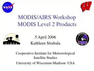
VIIRS vs. MODIS: Size, Power MODIS 2 m3/230 kg/147 W VIIRS <1.2 m3/250 kg/200 W 129 cm 118 cm 107 cm 65 cm 164 cm 138 cm 92-10-175
MODIS Ocean Science TeamTeam Members and Associate Team Members Mark Abbott Oregon State University Barney Balch Bigelow Otis Brown University of Miami Dennis.K.Clark NOAA/NESDIS Janet Campbell University of New Hampshire Ken Carder University of South Florida Wayne Esaias NASA Robert Evans University of Miami Howard Gordon University of Miami Frank Hoge NASA Kay Kilpatrick University of Miami Ed Kearns University of Miami Ricardo Letelier Oregon State University Peter Minnett University of Miami Ken Voss University of Miami
MODIS Ocean Science TeamSupport Jasmine Nahorniak Oregon State University Bruce Bowler Bigelow Mark Yarborough Moss Landing Tim Moore University of New Hampshire Bob Chen University of South Florida Sue Walsh University of Miami Jim Brown University of Miami Warner Behringer University of Miami Kevin Turpie GSFC, SAIC Ron Vogel (MODAPS) GSFC, SAIC Donna Thomas GSFC, SAIC Aumber Bhatti GSFC, SAIC Bob Woodward (SDST) GSFC, SAIC
TERRA MODIS NIGHTTIME 4mm SST MAY 2001 V 3.3.1 -2 5 10 15 20 25 30 35 Co MODIS/OCEAN GROUP GSFC, RSMAS
EOS MODIS SUCCESS CRITERIA Develop improved calibration and science products Process and reprocess the data to make it available for 6+ year mission life Distribute products and tools to the science and operational communities. Improve understanding of how to best implement operational transitions of a national climate time series There are many lessons learned from MODIS Assemble feedback from science community
MODIS Ocean Products • MODIS Instruments: • Terra (1030 morning), • Aqua (1330 afternoon) • 40 products: • 4 SST, • 36 Ocean Color • Resolution: • Spatial: • Level 2 - 1km, ~2000km x 2000km; • Level 3 - 4km, 39 km, 1 deg [all products are global] • Temporal Resolution: • Level 2 - 5 minute granule; • Level 3 - daily, 8 day week, monthly, yearly
MODIS Ocean data products • There are 86 ocean parameters available in over 100 categories of MODIS Ocean data types archived by (and may be obtained from) the NASA Goddard Distributed Active Archive Center. • The three basic groupings of MODIS ocean data parameters are: • ocean color • sea surface temperature • ocean primary production • Ocean Parameter categories: • 36 Ocean Color parameters • 4 Sea Surface Temperature parameters • 8 Primary Productivity parameters • (including 2 Primary Production indices) • 38 Quality Control parameters.
Processing levels Ocean color and sea surface temperature are available at a variety of processing levels: • Level 1 - Unprocessed top of the atmosphere radiance/reflectance • At 1-km spatial resolution • 5 minute granule time resolution • Level 2 swath data • At 1-km spatial resolution • 5 minute granule time resolution • Level 3 global binned or mapped data • spatial resolutions of 4.63km, 39km, or 1 degree • Time resolutions of one day, 8 days, a month or a year. • The binned data products use an integerized sinusoidal equal area grid (ISEAG). The mapped products use a Cylindrical Equidistant Projection.
OPP stat model (opp_hv) OPP s.a. model (opp_wk) L2 Sat 1 km OPP mapping (opp_map) ISEAG 4.63 km Time binning (mtbin) CED 4.88 km L3 binning (mspc/mmap) CED 39 km L2→L3 binning (msbin) CED 1o DATA BINNING PATHWAYS Ocean Color & SST Ocean Primary Productivity YEARLY PGE74 L3 L3 L3 L3 L4 L4 L4 L4 L4 PGE52 MONTHLY PGE73 L3 L3 L3 L3 8-DAY PGE54 L3 L3 L3 L3 L4 L4 L4 L4 PGE51 DAILY PGE20 L3 L3 L3 L3 L2 Binned Maps 1 km 4.6 km 4.9km 39km 1° =111 km Swath ISEAG Linear Linear Linear
Level 4 Productivity • Ocean primary production data is available only as binned or mapped Level 4 (i.e. L4) data. • Ocean Productivity outputs are averaged weekly or yearly. Like the L3 data, the L4 data is organized spatially as either 4km ISEAG gridded bins or as maps using a Cylindrical Equidistant Projection. The mapped data products are available in a choice of 4km , 39km, or 1 degree spatial resolutions. More than one model is used for deriving these data products and some quality statistics are available.
Where to get data and more information Information locations: MODIS Oceans home page • http://modis-ocean.gsfc.nasa.gov MODIS Oceans QA Browse 36km Imagery (MQABI) • http://mqabi.gsfc.nasa.gov • Select Terra collection 4 or Aqua Collection 3 Useful links to documentation and related web pages • http://modis-ocean.gsfc.nasa.gov/doclinks.html Data Ordering locations: NASA GES DAAC WHOM (NASA - Goddard DAAC) http://daac.gsfc.nasa.gov/ Select Ocean color ->MODIS->ocean EOS DATA GATEWAY EDG - http://modis.gsfc.nasa.gov/data/ordering.html
Team, Quality Assurance, Processing, and User data access relationship
8 Day (Weekly) Composites Terra Aqua
Development,characterization, and performance of the EOS MODIS sensors W. Barnes, X. Xiong, B. Guenther and V. SalomonsonNASA/GSFC Greenbelt, MD 20771SPIE/Earth Observing Systems VIIIAugust 3-6, 2003San Diego, CA
VIIRS: Heritage in Key Components Full-aperture Calibrators: Angular Momentum Compensator (SeaWiFs) Reflective Spectralon Solar Diffuser (MODIS TRMM-VIRS) Emissive V-Groove Blackbody (MODIS Design) Diamond-turned Postpolished All-reflective Optics: • Rotating Telescope (SeaWiFS) (less stray light vs. MODIS) 3-mirror Anastigmat • Aft Optics 4-mirror Anastigmat Passive Flat-panel Radiative Cooler (Raytheon IR&D) Stand-alone Electronics Module • Reliable, redundant design • Reprogrammable in flight Scan Control • MODIS & SeaWiFs Based Optical Encoders • <30 µrad Uncertainty High-performance 2nd-generation Focal Planes