Download
1 / 31
310 likes | 470 Vues
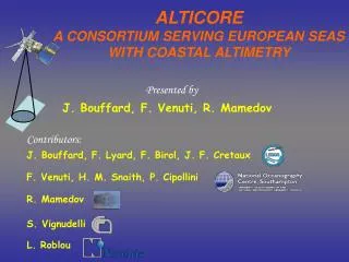
ALTICORE A CONSORTIUM SERVING EUROPEAN SEAS WITH COASTAL ALTIMETRY. Presented by. J. Bouffard, F. Venuti, R. Mamedov. Contributors:. J. Bouffard, F. Lyard, F. Birol, J. F. Cretaux. F. Venuti, H. M. Snaith, P. Cipollini. R. Mamedov. S. Vignudelli. L. Roblou. OUTLINE.

E N D
ALTICOREA CONSORTIUM SERVING EUROPEAN SEAS WITH COASTAL ALTIMETRY Presented by J. Bouffard, F. Venuti, R. Mamedov Contributors: J. Bouffard, F. Lyard, F. Birol, J. F. Cretaux F. Venuti, H. M. Snaith, P. Cipollini R. Mamedov S. Vignudelli L. Roblou
OUTLINE • Overview of coastal altimetry • Data Grids in coastal altimetry • Satellite altimetry applied to Caspian Sea
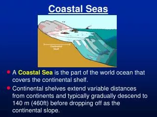
Altimetry: How does it work ? • Principle • corrections • Reference h = Horb - Halt - corrections - Href orbit Halt • Ionospheric • Sea Surface Bias • Tropospheric • Geophysics Horb h • Satellite altimetry is targeted for open ocean • New strategies have to be developed to improve altimeter data sets in coastal areas. Href
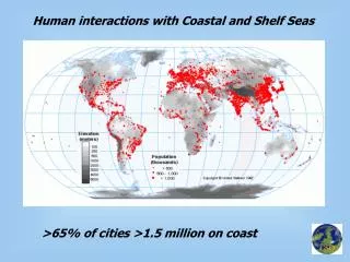
Motivations • Coastal Ocean is A region under stress and inherently complex to study … but relevant for stakeholders who require better access to better information, such as from satellite remote sensing, on which to builda scientifically sound decision-making. • Altimetry provides An all-weatherlook over the sea surface but … more importantly … into the water column from which to extract a broad variety of information for a broad variety of applications.
Difficulties / Solutions Difficulties • Proximity to land • - Contamination in footprints • Control by seabed • - e.g. complex tides • Rapid variations due to tides, winds and air pressure • - Undesirable aliasing in altimetric estimates • Incorrect or flagged data in official products (AVISO …) Solutions Need to develop improved data post-processing lines for coastal purposes : - Improved environmental and geophysical corrections - Adapted data editing - Improved wet tropospheric correction (radiometer decontamination) - Retracking of altimeter waveforms Need to resolve finer space and time scales: - Multi-satellites and multi-sensor applications - New technology in the future (AltiKa, Jason-2, CryoSat-2)
Related projects • • ALBICOCCA:Goal is to increase quantity and quality in coastal ocean • A joint project funded by ASI (IT) and CNES (FR) during 2002-2006 • Partners:CNR (Italy), LEGOS (France), NOCS (UK), Noveltis (France) • Focus on TOPEX/Poseidon mission at first • NW Mediterranean proposed test site • Backward reanalysis of AVISO products • A revised processing strategy • Replicability in other regions (e.g., India, Chile, etc.) • Generation of a 15 year high-resolution altimetric data set from multiple missions (TOPEX/Poseidon, Geosat, Envisat, Jason-1) • • ALTICORE:Goal is to increase data access in coastal ocean • A joint project funded by European Community (INTAS) during 2007-2008, • contract 06-100008-7927 • 3 partners added: SIO and RAS (Russia), IG (Azerbaijan) • Moving to RADS archiving format (open standard) • Extending ALBICOCCA to Black, Caspian,White, Barents seas • Adoption of Web Services and Grid concept • Regional archives regularly updated
The new processing strategy (MAP-Xtrack data) 1 Hz 1 10 100 Distance (in km) CTOH database Topex Poseidon, Jason 1, Envisat, GFO Specific editing Standard corrections Regional de-aliasing: MOG2D HF sampling: 10 & 20 htz data large scale error reduction Quality control procedure Sea level (SL) Along track Sea level Anomaly (SLA) (MAP-Xtrack data) 1/N ∑i=1,N(SLi) - Mean Sea level
Zones of test and validation 1. Northwestern Mediterranean 2. Northern Indian Ocean MAP-Xtrack: Strong qualitative and quantitative improvement compared to standard altimeter product 3. Humboldt Current system 4. Austral – Southern Indian Ocean New Zones of Application (In the framework of the ALTICORE project) : Black, Caspian, White, Barents seas
Comparisons at the Nice TG: % of RMS explained: Impact of the dataediting methodology Nice TG Nice TG Correlation: 0.78 Residual RMS: 3.9 cm RMS explained: 36% Correlation: 0.81 Residual RMS: 3.7 cm RMS explained: 40% Standard editing Specific editing MAP-Xtrack MAP-xtrack Medsea HF no editing The specific data editing methodology allows to decrease the noise in the altimeter time series % 10 40
Comparisons at the Nice TG: % of RMS explained: Impact of regional de-aliasing corrections Nice TG Nice TG Correlation: 0.78 Residual RMS: 3.9 cm RMS explained: 37% Regional de-aliasing MAP-Xtrack Medsea Correlation: 0.75 Residual RMS: 4.1 cm RMS explained: 33% % 10 40 MOG2D Medsea (Regional configuration) significantly improves the consistency between the altimeter and the Nice tide gauge time series. Global de-aliasing MAP-Xtrack Global
Comparisons at the Nice TG: % of RMS explained: Impact of the High Frequency sampling Nice TG Nice TG Correlation: 0.78 Residual RMS: 3.9 cm RMS explained: 37% Correlation: 0.81 Residual RMS: 3.7 cm RMS explained: 40% HF sampling 1HZ sampling MAP-Xtrack Medsea HF MAP-Xtrack Medsea % 10 40 The high frequency sampling allows to go closer to the coast
Number of data available Number of points (SLA) – cycle 5 to 364 along the coast of India 300 200 100 MAP-xtrack data Aviso product 0 The new processing strategy allows to recover more data far and close to the coast Number of points (SLA) the coast of the gulf of Lion. 95 120 95 120 MAP-xtrack data Aviso product MAP-Xtrack Medsea HF DT-(M) SLA Upd
More and better data available but HOW? ? • Data in native • format X • Online database • access • Data in native • format Y • CDs, mail • delivery Regional Centre Data Centre • Data in standard • format Z • offline ftp access Interoperability is key to success! Research Centre 13
What about a Grid? • A Grid is: A flexible, secure, coordinated resource sharing among dynamic collections of individuals, institutions and resources. • What to share: Computation? Storage? Services? • How to share: data discovery, security, data extraction, data use and delivery 14
A Data Grid for Coastal Altimetry • Neither computing nor storage resource sharing, only services provided through the internet • Security: only centralized authentication and activity logging • Only one typology of data • Not massive amounts of data: online data delivery is feasible 15
Data WS client Data WS server Application Application The Grid bricks: Web Services (WS) • Definition: a software system designed to support interoperable Machine to Machine interaction over a network [W3C] • In practice: imagine Web browser / Web server, but no humans involved 16
Web Services in Environmental Sciences • Different Protocols at different levels: • http, https • SOAP, REST, OpenDAP, etc. • OGC Web Services (Web Map Server, Web Coverage Server, Web Feature Server) • Software tools: • OpenDAP provides interfaces to Matlab, clients to read specific data formats (netCDF, HDF..) • OGC WCS is a standard and software tools are being developed to support it 17
Data Grid: other issues • Data formats: how to represent data? • Native formats (RADS) • GML (now ISO 19136) • Other standard formats: netCDF • Data storage model: where to store data? • RDBMS: fast access, robust, abstraction from format issues, flexible • Flat files: software tools available for common formats, scientists are used to flat files 18
ALTICORE Grid: find data ‘select’ (MySQL) ‘list’ ‘list’
ALTICORE Grid: get up-to-date data ‘update’ (MySQL) ‘select’ (MySQL) ‘get’ ‘get’ ‘get’ ‘check_upd’ ‘check_upd’
Is all this really needed? A case study • The Caspian Sea is characterized by dramatic level fluctuations • Off the shelves altimetry data products not optimized for coastal regions • Need to access improved data sets
Coverage of each of the satellite altimeters. Jason (Red), Topex / Poseidon (Yellow), GFO (Black), and Envisat, ERS (White)
Caspian Sea level variation from altimetry (grey circle) and from in-situ measurements (black square)
Caspian Sea Level variation deduced from altimetry measurements
Precipitation (Green), River Runoff (Black) and Discharge to Kara-Bogaz-Gol (Red)
Monthly Caspian Sea volume / annual average (Red) and monthly average Volga river Discharge (Black)
Conclusions • Coastal altimetry is useful and desirable (e.g.: by data integrators). • Altimetry over the coastal ocean demands a different processing. • Coastal altimetry is a young field of study … and the potential of 15 years of historical data is huge. • Progresses in coastal altimetry are promising (e.g., editing, tides, aliasing, etc.) but many issues remain and there is room for substantial improvement. • The key to success will be interoperability: not just more and better data, but also better access and delivery of the proper altimetric information to the right audience.
Collaborations and Future Perspectives • ALTICORE is a multidisciplinary project that brings together experiences and know how from Environmental Sciences, Remote Sensing and Computer Science • Scientific and technological collaboration is key • ALTICORE aims at strengthening the members’ partnership in view of an application to submit to the 7th Framework Programme (FP7)