RUC, Rapid Refresh, HRRR, HCPF update
500 likes | 1.02k Vues
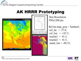
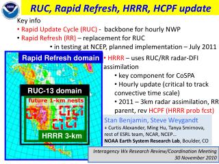
Key info Rapid Update Cycle (RUC) - backbone for hourly NWP Rapid Refresh (RR) – replacement for RUC in testing at NCEP, planned implementation – July 2011. Rapid Refresh domain. RUC, Rapid Refresh, HRRR, HCPF update. HRRR – uses RUC/RR radar-DFI assimilation

RUC, Rapid Refresh, HRRR, HCPF update
E N D
Presentation Transcript
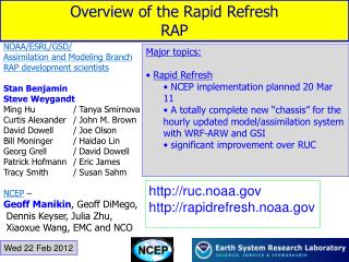
Key info • Rapid Update Cycle (RUC) - backbone for hourly NWP • Rapid Refresh (RR) – replacement for RUC • in testing at NCEP, planned implementation – July 2011 Rapid Refresh domain RUC, Rapid Refresh, HRRR, HCPF update • HRRR – uses RUC/RR radar-DFI assimilation • key component for CoSPA • Hourly update (critical to track convective time scale) • 2011 – 3km radar assimilation, RR parent, rev HCPF (HRRR prob fcst) RUC-13 domain future 1-km nests Stan Benjamin, Steve Weygandt + Curtis Alexander, Ming Hu, Tanya Smirnova, rest of ESRL team, NCAR, NCEP… NOAA Earth System Research Lab, Boulder, CO HRRR 3-km Interagency Wx Research Review/Coordination Meeting 30 November 2010
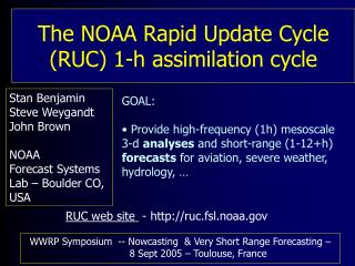
Why have a RUC or Rapid Refresh? • Provide high-frequency (hourly) mesoscale analyses, short-range model forecasts • Assimilate (“merge”) all available observations into single, physically consistent 3-d grid such that • forecasts are improved • Focus on sensible weather, aviation and other hazards: • Thunderstorms, severe weather, winter storms • Detailed surface temperature, dewpoint, winds • Icing, ceiling and visibility, turbulence • Upper-level winds • Users: • NWS and other forecasters • aviation and other transportation • severe weather forecasting • hydrology, energy (load, renewable) “Situational Awareness Model”
Hourly Updated NOAA NWP Models Rapid Refresh (RR) replaces RUC at NCEP planned for July 2011 - WRF/GSI, both with RUC-based enhancements 13km Rapid Refresh 13km RUC 3km HRRR RUC – current NCEP-oper model, new 18h fcst every hour High-Resolution Rapid Refresh Experimental 3km nest inside RUC or RR, new 15-h fcst every hour, central to 2-8h CoSPA
RUC / RR hourly cycling 18-h fcst 18-h fcst 18-h fcst Initial Condition Fields Hourly RUC or RR DDFI DDFI 1-hr fcst 1-hr fcst 1-hr fcst Back- ground Fields Analysis Fields 3DVAR 3DVAR Obs Obs Time (UTC) 11 12 13
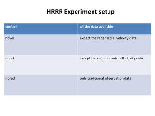
3dvar 3dvar Obs Obs RUC/Rapid Refresh Hourly Assimilation Cycle Cycle hydrometeor, soil temp/moisture/snow plus atmosphere state variables Hourly obs Data Type ~Number Rawinsonde (12h) 150 NOAA profilers 35 VAD winds 120-140 PBL – prof/RASS ~25 Aircraft (V,temp) 3500-10000 TAMDAR (V,T,RH) 100-300 Surface/METAR 2000-2500 Buoy/ship 200-400 GOES cloud winds 4000-8000 GOES cloud-top pres 10 km res GPS precip water ~300 Mesonet (temp, dpt) ~8000 Mesonet (wind) ~4000 METAR-cloud-vis-wx ~1800 AMSU-A/B/GOES radiances – RR only Radar reflectivity/ lightning 1km 1-hr fcst 1-hr fcst 1-hr fcst Background Fields Analysis Fields Time (UTC) 11 12 13
Diabatic Digital Filter Initialization (DDFI) -40 min -20 min Init +20 min Backwards integration, no physics Forward integration, full physics Apply latent heating from radar reflectivity, lightning data Obtain initial fields with improved balance, vertical circulations associated with ongoing convection RUC/RR model forecast Radar reflectivity assimilation in RUC and Rapid Refresh
Radar reflectivity assimilation in RR and RUC - “DFI-radar” technique – reason for HRRR successreflectivity assimilation example below – from RR Upper-level Divergence Low-level Convergence NSSL radar reflectivity (dBZ) K=17 U-comp. diff (radar - norad) K=4 U-comp. diff (radar - norad) 14z 22 Oct 2008 Z = 3 km
Hourly HRRR Initialization 15-h fcst 15-h fcst Hourly HRRR 18-h fcst 18-h fcst 18-h fcst Interp to 3 km grid Interp to 3 km grid Boundary Conditions Initial Condition Fields DDFI DDFI 1-hr fcst 1-hr fcst 1-hr fcst Back- ground Fields Hourly RUC or RR Analysis Fields 3DVAR 3DVAR Obs Obs Time (UTC) 11 12 13
Models at NOAA/ESRL/GSD/AMB RR physics behavior similar to RUC – good for aviation, convective environment , surface and sensible weather NCEP upgrade from RUC to RR provides advanced model and analysis components - WRF-ARW: advanced numerics, phys options, non-hyd option - GSI: advanced satellite assim, EnKF development - Both community-based, ongoing code contributions
RUC/RR cloud / radar assimilation flowchart 1-h fcst qv, qc, qi, qr, qs, qg Sat cloud-top observations METAR cloud observations 3D Radar reflectivity Lightning Merge observations 3D arrays of precipitation and cloud information (observed Yes / No / Unknown) Modify 1-h forecast cloud, hydrometeor fields Diagnose 3D latent heating from radar / lightning data Determine 2D convective suppression field Analysis RUC-3dvar GSI-3dvar 2D convective suppression Modified qv, qc, qi, qr, qs, qg 3D latent heating Model RUC WRF Apply within pre-forecast DFI Forecast integration
Cloud and Hydrometeor Analysis Incremental adjustment based on information from multiple observation types - Uses METAR, satellite, radar, lightning data - Updates RR 1h-fcst RR hydrometeor, water vapor fields - Generates latent heating from radar and lightning data
Recent development:use of NASA Langley satellite cloud data Cloud Top Height Analysis RR with NASA data – over full RR domain RR with NESDIS data - only over RUC domain
RUC to Rapid Refresh • CONUS domain • (13km) • RUC 3DVAR • RUC model + postprocessing • North American • domain (13km) • GSI (Gridpoint • Statistical • Interpolation) • (incl. RR enhancements) • WRF-ARW model (RR version) + • UniPost (with enhancements)
2010 – Changes to RUC • Extension of RUC to 18h every hour (SPC, AWC request) • Modified RUC vertical coordinate (dpsig-max = 10 hPa) • Reversal from 10 hPa to 15 hPa – 10/25/2010 • Addition of Canadian aircraft observations • -- 1000-1200 reports / hour during flight ops hours • TAMDAR – only NOAA-purchased obs • UPS, Southwest – moisture data now being assimilated in ESRL version • Extension of no-echo volumes to PBL height • 1/3 latent heat specification in DFI forward step (condensate assumed to be produced over 30-min period – changed from 10 min) • RH-pseudo-obs at ceiling from METAR cloud obs
Rapid Refresh Partial Cycling GFS model GFS model RR spin-up cycle RR spin-up cycle Observation assimilation 00z 03z 06z 09z 12z 15z 18z 21z 00z Observation assimilation RR Hourly cycling throughout the day - Hourly cycling of land surface model fields - 6 hour spin-up cycle for hydrometeors, surface fields
height wind 12h forecast error (lower is better) RUC(backup) vs. RR 25-30 Nov 2010 RH Temperature
Key updates to RR in last 3 mos. • Change to rotated lat-lon (RLL) grid to include Aleutians • Corrections to radar/satellite processing in analysis, corrections for use of surface data • Intense inquiry on 6h RR forecast skill, esp. for upper-level winds • Determination of WRF sensitivity to water vapor and hydrometeor changes from cloud/radar analysis • WRF error found for RLL grid, fix implemented • Height diagnostic for ARW corrected
Rapid Refresh Implementation Update • Planned date for RR implementation at NCEP – July 2011 (4Q) • Availability date at NCEP for RR grids from frozen version - 30 November 2010 http://rapidrefresh.noaa.gov
HRRR Multi-Scale Reflectivity Verification 10 June – 26 Sept 2010 20 dBZ threshold NSSL refl. mosaic Convective Initiation: HRRR missing exact location of small-scale early thunder- storm development Convective Initiation: “Neighborhood” verification shows HRRR capturing “regions” where thunderstorms are developing 80 km scale 3 km scale
Reflectivity verification • RUC vs. RR vs. HRRR • Summer 2010 • CSI • 80km averaging • HRRR has best skill (over RUC, RR) for all durations • Skill slightly decreases from JuneJulyAugust as large-scale forcing also decreases June July August HRRR RR RUC
25 dBZ threshold 15 dBZ threshold • Reflectivity verification • RUC vs. RR vs. HRRR • June-August 2010 • CSI • 80km averaging 35 dBZ threshold HRRR • HRRR has much better skill (over RUC, RR) as dBZ threshold increases from 152535 dbZ • RR slightly better than RUC RR RUC
HRRR POD Bias HRRR Reflectivity verification: RUC vs. RR vs. HRRR 35 dBZ threshold, June-Aug 2010, 80km avging RUC CSI FAR HRRR RR RUC
HCPF - Convective probability forecasts from HRRR time-lagged ensemble (show with deterministic fcst) Reflectivity (dBZ) Probability (%) 21z 16 July ‘09 Verification 15z + 6h HRRR and HCPF
CoSPA LAMP 8 h Forecast 8 h Forecast 16 September 2010 Last CoSPA-2010 Blitz day – 16 September NYC severe weather and tornado Slides from Matthias Steiner - NCAR Observation at 21Z
CoSPA & CCFP 8 h Forecast 8 h Forecast HRRR 11h fcst init 10z Basis for CoSPA 16 September 2010 At longer lead times CoSPA based mostly on HRRR guidance Observation at 21Z
Much better guidance from earlier HRRR runs for 16 Sept NYC case 09z+12h Not used in CoSPA HRRR - 10z+11h Used in CoSPA HRRR 08z init 13h fcst Not used in CoSPA Obs radar 21z Sept 16
Rapid intensification w. of NYC from 20-21z for 16 Sept case Also captured by 08z HRRR run (12h, 13h forecasts below) Obs radar 20z Sept 16 HRRR 08z init 12h fcst 08z+13h Not used in CoSPA Obs radar 21z Sept 16
HCPF - Convective probability forecasts from HRRR time-lagged ensemble Probability (%) 09z + 13h HCPF valid 22z Forecasts some risk for NYC development 22z 16 Sept ’10 Verification
HRRR Multi-Scale reflectivity verification 10 June – 26 Sept 2010 25 dBZ 8-h fcst East verif observed storm coverage valid (GMT) valid (EDT) init (EDT) • Afternoon jump in skill for coarsened verification grid • “neighborhood” skill for CI and early evolution
HRRR scientific issues 1. Difficulty maintaining MCS propagation (microphysics ? , mid-level moisture ? , 1-km resolution ? Other initial condition issues ? ) 2. Difficulty maintaining elevated convection 3. Lag in CI for early morning runs
HRRR 1-km Nested Grid Experiments (useful experiments, not the answer for now) Initial conditions from the RUC, same as operational HRRR Two-way nested inner 1-km domain defined in vicinity of MCS All other settings identical to operational HRRR 18 June 2010 19 July 2010 4 August 2010 ~2x run-time ~2x run-time From Eric James
21 UTC 4 August 2010 (6-h forecasts) Significant Improvement MCS maintenance No Nest With Nest HRRR-primary HRRR-dev
HRRR-Dev and HRRR-Primary Intercomparison 21-22 Oct 2010 Texas Panhandle MCS From Eric James
Oct. 21, 2010 1300 UTC 0-h HRRR Forecasts RUC third TTEN +METAR-cldRH RUC full TTEN Primary HRRR Developmental HRRR
Oct. 21, 2010 1600 UTC 3-h HRRR Forecasts RUC third TTEN+METAR-cldRH RUC full TTEN Primary HRRR Developmental HRRR
Oct. 21, 2010 1900 UTC 6-h HRRR Forecasts
Oct. 21, 2010 2200 UTC 9-h HRRR Forecasts
Oct. 22, 2010 0100 UTC 12-h HRRR Forecasts RUC third TTEN+METAR-cldRH RUC full TTEN Primary HRRR Developmental HRRR
Oct. 22, 2010 0400 UTC 15-h HRRR Forecasts RUC third TTEN+METAR-cldRH RUC full TTEN Primary HRRR Developmental HRRR
Improved 10m wind 6h forecasts from HRRR compared to RUC Vector error for HRRR 6h forecast - against all METARs in CONUS . Vector error for RUC (backup) 6h forecast – “ October 2010
Upcoming HRRR Changes Fall/Winter 2010 Improved mapping of radar reflectivity (no-echo area, latent heating magnitude) Modifications to WRF model physics (esp. cloud microphysics) to improve HRRR forecasts for MCSs (mesoscale convective systems) Reduce HRRR model latency by ~30 min to attain ~2 hr latency Winter/Spring 2011 Switch parent model from RUC to RR, update RR cloud/hydrometeor assim Assimilate 3-d radar radial wind data Assimilate radar reflectivity at 3-km (hydrometeors, temperature tendency) Test assimilation of SatCast as proxy radar, add to actual radar and lightning
Switch from RUC to RR initial/boundary conditions 1-h HRRR forecasts Valid 23z April 4, 2010 from RR from RUC NSSL verif
Switch from RUC to RR initial/boundary conditions from RR 4-h HRRR forecasts Valid 02z April 5, 2010 from RUC NSSL verif
Summary • Keys for HRRR success: • Accuracy in mesoscale environment from 13km RUC/RR parent assim/model • Effective radar reflectivity assimilation (“DFI-radar” technique) • Improved HRRR in 2011 • better radar assimilation – no-radar, radial wind, focus on improved 3-6h • RR as parent model • applicable to winter weather, surface conditions, ceiling, turb, icing, etc. • NOAA/ESRL demo will continue until NCEP resources available (FY13?) • Rapid Refresh – • In mature testing at NCEP, some changes being finalized @ESRL • Expected implementation date @NCEP – July 2011 • Grids available via ftp from NCEP – starting 30 Nov 2011 • HRRR can provide an estimate of the likelihood (probability), timing, and location of convection and other phenomena through a time-lagged “ensemble-of-opportunity” – HPCF (HRRR Convective Probabilistic Forecast), incorporate in VSREF • Testing of 1-km 2-way nests in HRRR already performed, will provide terminal-scale information for NextGen requirements and improve forecasts of convective evolution
WRF-Chem and RR/HRRR – (ESRL, also NCEP, NCAR) Primary WRF-Chem development and coordination occurring in ESRL Next few years: introduce simple version of WRF-Chem into the RR (or even HRRR) as a first step toward integrated operational weather-visibility-air quality forecasting - Aerosol direct effect on radiation (e.g. solar direct-beam irradiance, surface temp forecasts) - Improved warm-rain and ice nucleation in microphysics (aerosol indirect effects) for better cloud/precip forecasts (impact on ceiling, visibility, icing, surface temp) - First step: RR-Chem, HRRR-chem put together by ESRL * Once per day to 48h * Aerosol cycling only Aerosol optical depth RR-chem – 18h fcst valid 18z 30 Nov 10
FIM-Chem-Ash model – FIM-chem + volcanic ash (10 size bins) – init 12z 15 April 2010 – Eyjafjallaköll - Variable shown – integrated ash - Georg Grell-GSD + FIM development group
Future plans for advanced NWP and DA 2011 – Rapid Refresh operational at NCEP 2013 – Ensemble Rapid Refresh– NARRE 2014 – High Resolution Rapid Refresh operational at NCEP for CONUS 2015 – Add operational Alaska HRRR 2016 – CONUS Ensemble HRRR - HRRRE 2017 – Global Rapid Refresh (GRR) 2018-2030 - 15-min5-min updating HRRR - Alaska • NEMS-based NMM, ARW cores • Hourly updating with GSI, possibly EnKF/hybrid/var assimilation • Initially 6 members, 3 each core • Forecasts to 24-h • NMM to 84-h 4x per day HRRR-CONUS Rapid Refresh North American Rapid Refresh Ensemble • Other improvements • Add inline chem, chem DA • Storm-scale radar assimilation • Sub-hourly DA