Quiz 07
B. A. Quiz 07. Radar Scan Mode for the large radar image: CAPPI or PPI ? Hint, both radar images are for the same time. Why is the Doppler Image showing no precipitation near the radar? Pick from the list of possible options. No Pcpn 3.5 Cone of Silence Virga Hole Attenuation

Quiz 07
E N D
Presentation Transcript
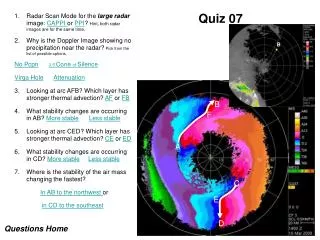
B A Quiz 07 • Radar Scan Mode for the large radar image: CAPPI or PPI? Hint, both radar images are for the same time. • Why is the Doppler Image showing no precipitation near the radar? Pick from the list of possible options. • No Pcpn3.5 Cone of Silence • Virga HoleAttenuation • Looking at arc AFB? Which layer has stronger thermal advection? AF or FB • What stability changes are occurring in AB? More stableLess stable • Looking at arc CED? Which layer has stronger thermal advection? CE or ED • What stability changes are occurring in CD? More stableLess stable • Where is the stability of the air mass changing the fastest? • In AB to the northwest or • in CD to the southeast B F A B A C E D Questions Home
You are correct! Congratulations Yes, it must be a PPI image – you had a 50-50 chance of being right. Did you guess? Your answers to the following questions will find out.
Sorry… that is not the answer we were looking for… Sorry… it is not a CAPPI. You did have a 50-50 chance of guessing the right answer and you guessed wrong. You now know the correct answer. Hint!
You are correct! Congratulations Yes, the no echo zone is a classic “Virga Hole” depicted in PPI scans. The highest scan angle does determine the radius of the virga hole. If the Doppler looked straight up, the precipitation falling to 1.6 km would be detected. At the 3.5 degree angle, the precipitation is intercepted at a range of about 22 km. You could do the trigonometry to check. The Doppler 3.5 cannot answer the question if the hydrometeors are reaching the ground at larger ranges. When using radar one must always remember the geometry of the scan. B F The Virga Hole A C E D
Sorry… that is not the answer we were looking for… but technically you are still correct. Technically there is “No Precipitation “ at the ground but there are hydrometeors above the ground even though they do not show up on the 1.5 km CAPPI. All of the hydrometeors are above 1.6 km so they do not and should not appear on the 1.5 km CAPPI even though the meteorologist needs to know of their existence. If you assume that precipitation only occurs when hydrometeors reach the ground you are correct. Practically, “hydrometeors” was to long to fit the space allowed although that is what is implied. So technically, you are right but please try again.
Mmmm… that is close but not what we were looking for… but there is an element of “correctness”. Would you believe that the “3.5 degree Cone of Silence“ doesn’t quite compute? Aw yeesss Chief, there is indeed a “cone of silence” but if precipitation is falling to the ground, it will be intercepted by even the 3.5 degree scan. The angle of the highest radar scan does determine the range at which the PPI intercepts the hydrometeors. Thus the diameter of the no echo area is a function of the scan but it doesn’t answer the entire question. Try again Agent 86 or Agent 99. But you do get part marks veer veer
Sorry… that is really not the answer we were looking for… Sorry… “Attenuation “ is really not correct. There is no attenuation possible, dome wetting or whatever to block the radar microwaves from exiting the radar dome… Very funny though. Try again.
Sorry… that is not the answer we were looking for… Opps … try again. B F The Virga Hole A C E D
You are correct! Congratulations AF is much longer than FB and thus subtends a larger angle from the radar. There is more directional wind shear. The height interval for the AF wind shear is about the same as that for the FB wind shear. The magnitude of the thermal advection is determined by the vertical wind shear so AF is the clear winner. Both AF and FB veer clockwise with height and thus are experiencing warm advection. B F The Virga Hole A C E D
You might be correct! Congratulations Yes. With the VWS in layer AF producing more warming than that in layer FB, the entire layer AB must be destabilizing – becoming more unstable. One can use this to characterize the type of precipitation that one can expect. B F The Virga Hole A C E D
Sorry… that is not the answer we were looking for… Sorry. With the VWS in layer AF producing more warming than that in layer FB, the entire layer AB must be destabilizing – becoming more unstable. Differential warming between layers can be a powerful mechanism to destabilize an air mass. B F The Virga Hole A C E D
You are correct! Congratulations CE is much longer than ED and thus subtends a larger angle from the radar. There is more directional wind shear. The height interval for the CE wind shear is smaller than the wind shear for ED. The magnitude of the thermal advection is determined by the vertical wind shear so CE is the clear winner. Both CE and ED veer clockwise with height and thus are experiencing warm advection. B F The Virga Hole A C E D
Sorry… that is not the answer we were looking for… Opps … try again. B F The Virga Hole A C E D
You are correct! Congratulations Yes. Considering only layer CD, the VWS in layer CE is producing more warming than that in layer ED. The entire layer CD must be destabilizing – becoming more unstable. One can use this to characterize the type of precipitation that one can expect. B F A C E D
Sorry… that is not the answer we were looking for… Sorry. Try again. B F The Virga Hole A C E D
You are correct! Congratulations Yes. The air mass is becoming more unstable faster to the southeast than to the northwest. The main reason for this is that the height change for vector AB is equally partitioned between AF and FB. In the case of CD, most of the height change is in vector ED so that the direction shear of CE occurs in a very small height interval – strong thermal advection. One would expect convective cloud to form south of the radar before over areas to the north. This makes intuitive sense since the situation is that of a warm frontal surface approaching from the south. These techniques are only intended to be operational and quantitative. Put away your slide rules… B F A C E D
Sorry… that is not the answer we were looking for… Sorry. Try again. B F The Virga Hole A C E D