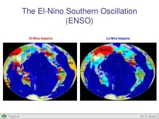
El Nino Southern Oscillation
160 likes | 520 Vues
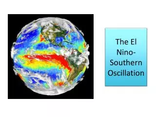
El Nino Southern Oscillation. Benedetto Schiraldi. Outline. Over view Normal Walker Circulation El Nino Event Circulation La Nina Event Circulation How Does ENSO Influence US? El Nino SST Images Mechanism for El Nino. Walker Circulation.

El Nino Southern Oscillation
E N D
Presentation Transcript
El Nino Southern Oscillation Benedetto Schiraldi
Outline • Over view • Normal Walker Circulation • El Nino Event Circulation • La Nina Event Circulation • How Does ENSO Influence US? • El Nino SST Images • Mechanism for El Nino
Walker Circulation http://www.srh.noaa.gov/images/fwd/climate/enso/pacific-el.GIF
El Nino Event http://www.srh.noaa.gov/images/fwd/climate/enso/pacific-el.GIF
El Nino Winter Florida State University Center For Ocean-Atmosphere Prediction Studies
La Nina Winter Florida State University Center For Ocean-Atmosphere Prediction Studies
Sea surface temperature anomaly during the peak of the 2009-10 El Niño, the strongest Central Pacific El Niño observed to date. High Resolution (Source: NASA JPL).
La Nina 2010 Image from NASA/JPL Ocean Surface Topography team oceanography satellite
Deviations from normal sea surface temperatures (left) and sea surface heights (right) at the peak of the 2009-2010 central Pacific El Niño, as measured by NOAA polar orbiting satellites and NASA's Jason-1 spacecraft, respectively. The warmest temperatures and highest sea levels were located in the central equatorial Pacific. Image credit: NASA/JPL-NOAA
Possible factor which Influences El Nino • Madden Julian Oscillation- • 30-90 day cycle of eastward propagating deep convection • Strong MJO have been known to cause intense breakdown of Walker circulation resulting in a Kelvin wave across the equator causing the rapid onset of an El Nino event (Ie. 1982 El Nino)
References • Introduction to Physical Oceanography, Robert Stewart, 2002 • California Institute of Technology, NASA Jet Propulsions Laboratory http://www.jpl.nasa.gov/ • Florida State University, Center For Ocean Atmosphere Predictions Studies http://www.coaps.fsu.edu/ • National Oceanic and Atmospheric Administration Southern Head Quarters http://www.srh.noaa.gov/images/fwd/climate/enso/pacific-el.GIF