
Uploaded by
azure
2 SLIDES
136 VUES
20LIKES
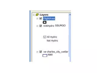
Understanding NWI, SSURGO, and DRG: Key Mapping and Soil Data Systems
DESCRIPTION
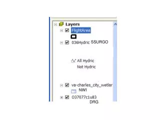
This overview provides insights into three essential soil information systems: the National Wetlands Inventory (NWI), the Soil Survey Geographic Database (SSURGO), and Digital Raster Graphics (DRG). NWI focuses on the identification and classification of wetlands, while SSURGO offers detailed soil maps and data crucial for land-use planning and resource management. DRGs serve as raster representations of topographic maps that enhance visualization and analysis. Together, these systems support environmental assessment, conservation, and land use planning.
Download
1 / 2
Télécharger la présentation 
Understanding NWI, SSURGO, and DRG: Key Mapping and Soil Data Systems
An Image/Link below is provided (as is) to download presentation
Download Policy: Content on the Website is provided to you AS IS for your information and personal use and may not be sold / licensed / shared on other websites without getting consent from its author.
Content is provided to you AS IS for your information and personal use only.
Download presentation by click this link.
While downloading, if for some reason you are not able to download a presentation, the publisher may have deleted the file from their server.
During download, if you can't get a presentation, the file might be deleted by the publisher.
E N D


More Related