Advanced MSc in Geospatial Intelligence for Future Spatial Data Experts
The MSc in Geospatial Intelligence program equips graduates with the technical expertise and practical skills required to excel in the booming fields of geospatial data and GIScience. Applicants should have a background in software engineering or programming, focusing on subjects like geovisualisation, spatial information science, and advanced web technologies. The program prepares students for cutting-edge research and robust career prospects in mobile and web mapping industries, including companies like Google and ESRI. Discover the potential of context-aware navigation and 3D visualisation with our comprehensive curriculum.

Advanced MSc in Geospatial Intelligence for Future Spatial Data Experts
E N D
Presentation Transcript
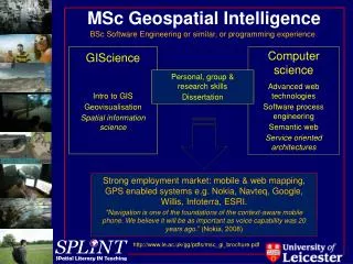
MSc Geospatial Intelligence BSc Software Engineering or similar, or programming experience GIScience Intro to GIS Geovisualisation Spatial information science Computer science Advanced web technologies Software process engineering Semantic web Service oriented architectures Personal, group & research skills Dissertation Strong employment market: mobile & web mapping, GPS enabled systems e.g. Nokia, Navteq, Google, Willis, Infoterra, ESRI. "Navigation is one of the foundations of the context-aware mobile phone. We believe it will be as important as voice capability was 20 years ago.” (Nokia, 2008) Equipped for PhD research: 3D visualisation/dynamic interaction with geodata, geoWeb (semantics & mapping), mobile & augmented realities, geo-semantics & ontologies http://www.le.ac.uk/gg/pdfs/msc_gi_brochure.pdf