Shoebury Flood Risk Management Scheme Options
20 likes | 126 Vues
Evaluate Option 2 and Option 3 for flood risk management in Shoebury. Consider benefits, impacts, and implications of each option for the community and environment.

Shoebury Flood Risk Management Scheme Options
E N D
Presentation Transcript
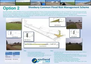
Shoebury Common Flood Risk Management Scheme Option 2 East of the Common – Install a flood gate across the junction between Ness Road, Shoebury Common Road and Waterford Road to a level of 5.5mAOD (2-2.7m above the existing road level). To the north of the road junction construct a reinforced concrete flood wall also to a level of 5.5mAOD along Waterford Road tying into high ground; and to the south replace the existing boundary wall around Coastguard station with a new flood wall to a level of between 5.5 and 5.8mAOD, tying into the existing defences in front of the Coastguard station. Behind the Common – Properties on Lodwick are protected through a reinforced concrete wall to 5.5mAOD tied into surrounding high ground (2 – 2.9m above the existing ground level on road) with new flood gates providing access to the properties. . • Pros • Common will remain largely unaffected • Promenade and sea views will remain unaffected • Cost prohibitive beach recharge is not required • Raising the relative height of defences negates the need to raise the road and the negative impacts this entails • Cons • Road closures both during construction and flood events will be required, resulting in disruption to local traffic • Significant disruption to existing services/ utilities and drainage in road • Uncle Tom’s Cabin, beach huts, public toilets, car park, common and road will be subject to an increasing risk of coastal flooding and may in the future be temporarily unavailable (following a flood event) or permanently abandoned • Construction of large walls will have an impact on the local landscape • Requires permission from local highways team, which may not be granted • Barriers across the road affect emergency access during a flood event • Substantial disruption to local residents, businesses and coastguard station during construction
Shoebury Common Flood Risk Management Scheme Option 3 East of the Common – Raise the level of the road at the junction between Ness Road, Shoebury Common Road and Waterford Road (1.6m above the existing road level) and install a smaller flood gate to a level of 5.5mAOD (approximately 0.6-1.2m above the raised road level). To the north of the road junction construct a reinforced concrete flood wall to a level of 5.5mAOD along Waterford Road tying into high ground; and to the south replace the existing boundary wall around Coastguard station with a new flood wall to a level of between 5.5 and 5.8mAOD, tying into the existing defences in front of the Coastguard station. Behind the Common – Properties on Lodwick are protected through a reinforced concrete wall to 5.5mAOD tied into surrounding high ground (approximately 2.2-2.9m above the existing ground level on road) with new flood gates providing access to the properties. . • Pros • Common will remain largely unaffected • Promenade and sea views will remain unaffected • Cost prohibitive beach recharge is not required • Raising of the road reduces the height of wall and gate required compared to Option 2 and therefore road closures required less frequently • Cons • Road closures both during construction and flood events will be required, resulting in disruption to local traffic • Significant disruption to existing services/utilities and drainage in road • Uncle Tom’s Cabin, beach huts, public toilets, car park, common and road will be subject to an increasing risk of coastal flooding and may in the future be temporarily unavailable (following a flood event) or permanently abandoned • Construction of large walls will have an impact on the local landscape • Requires permission from local highways team, which may not be granted • Barriers across the road affect emergency access during a flood event • Substantial disruption to local residents, businesses and coastguard station during construction.