Download
1 / 2
20 likes | 100 Vues
This study compares cloud fraction estimates from six platforms at various scales over the Southern Great Plains between 1997 and 2011. Results indicate differences in cloud fractions among methods, highlighting the importance of caution and consistency in cloud fraction retrieval.

E N D
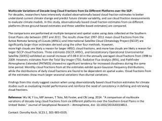
Multiscale Variations of Decade-long Cloud Fractions from Six Different Platforms over the SGP: For decades, researchers have intensively studied observationally based cloud fraction estimates to better understand current climate change and predict future climate variability, and use cloud fraction measurements to evaluate climate models. In this study, observationally based cloud fraction estimates from six different platforms (three ground-based estimates and three satellite-based estimates) are compared. The comparisons are performed at multiple temporal and spatial scales using data collected at the Southern Great Plains site between 1997 and 2011. The results show that 1997-2011 mean cloud fractions from the Active Remote Sensing of CLouds (ARSCL) and International Satellite Cloud Climatology Project (ISCCP) are significantly larger than estimates derived using the other four methods. However, more high clouds are likely a reason for larger ARSCL cloud fractions, and more low clouds are likely a reason for larger ISCCP cloud fractions. Three estimates (ISCCP, ARSCL, and Geostationary Operational Environmental Satellite [GOES]) exhibited an overall increase of 0.08-0.10 in the annually averaged cloud fractions from 1998 to 2009. However, estimates from the Total Sky Imager (TSI), Radiative Flux Analysis (RFA), and Pathfinder Atmospheres Extended (PATMOS) showed no significant tendency for increased cloudiness during the same time period. Monthly cloud fractions from all the estimates exhibit quasi-Gaussian frequency distributions, while the distributions of daily cloud fractions are found to be dependent on spatial scales. Cloud fractions from all the estimates show much larger seasonal variations than diurnal variations. Findings from this study suggest caution when using observationally based cloud fraction estimates for climate studies such as evaluating model performance and reinforce the need of consistency in defining and retrieving cloud fractions. Reference: Wu W, Y Liu, MP Jensen, T Toto, MJ Foster, and CN Long. 2014. "A comparison of multiscale variations of decade-long cloud fractions from six different platforms over the Southern Great Plains in the United States." Journal of Geophysical Research – Atmospheres, doi: 10.1002/2013JD019813. Contact: Dorothy Koch, SC23.1, 301-903-0105.
Figure 1 The geographic locations and grid sizes of the cloud fraction estimates. The gray solid box represents the Southern Great Plains Central Facility. The boxes outlined by colored dashed lines represent spatial scales at: 1) 0.5°, latitude/longitude (cyan, for GOES); 2) 1°, latitude/longitude (red, for GOES and PATMOS-x); 3) 2.5°, equal area (orange, for ISCCP D1); 4) 3°, latitude/longitude (green, for GOES and PATMOS-x); and 5) 5°, latitude/longitude (blue, for GOES, PATMOS-x, ISCCP D1, and ISCCP D2). Figure 2 The 1997-2011 mean diurnal (a-d), annual (e-h) and interannual (i-l) cloud fractions. Colors and lines: 1) cyan: ARSCL; 2) green: TSI; 3) blue: 160° field of view RFA; 4) red: solid, dashed, dotted, and dash-dotted: GOES over 0.5°, 1°, 3°, and 5° latitude/longitude; 5) black solid, dashed, and dotted: PATMOS-x over 1°, 3°, and 5° latitude/longitude; 6) the brown solid, dashed, and dotted: 2.5° equal-area ISCCP D1, 5° latitude/longitude ISCCP D1, and 5° latitude/longitude ISCCP D2. Black triangle, circle, and square: means from 1°, 3°, and 5° PATMOS-x.