Laser Pulse Depth Measurement and Lidar Principles for Hydrographic Surveys
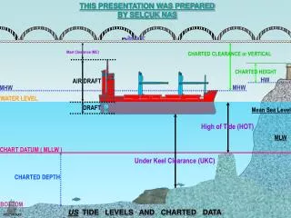
This document provides an in-depth overview of the operating principles of Lidar and DGPS technologies utilized for hydrographic surveying, specifically focusing on the measurement of depths and elevations using initial laser pulse data from altitudes around 400 meters. It outlines the methodology for determining bottom return depths beneath 50 meters and the necessary corrections for tidal influences. The data gathered is referenced to the water level and requires adjustments to align with chart datums. Various tidal benchmarks and vertical datum offsets are included for accurate calculations in marine surveys.

Laser Pulse Depth Measurement and Lidar Principles for Hydrographic Surveys
E N D
Presentation Transcript
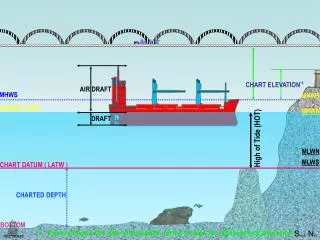
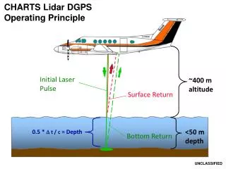
Initial Laser Pulse ~400 m altitude Surface Return 0.5 * t / c = Depth Bottom Return <50 m depth CHARTS Lidar DGPSOperating Principle UNCLASSIFIED
CHARTS Lidar DGPSOperating Principle GPS Constellation Raw depths and elevations referenced to water level In-situ or predicted tides required to reduce data to chart datum UNCLASSIFIED
HydroMap Tide Model (ftp://ftp.seal.navy.smil.mil/mscwest-inbox/) UNCLASSIFIED
Initial Laser Pulse ~400 m altitude 0.5 *t / c = aircraft to bottom distance Bottom Return <50 m depth CHARTS Lidar KGPSOperating Principle UNCLASSIFIED
From benchmark datasheet From simultaneous measurements From averaged OPUS solution CHARTS Lidar KGPSOperating Principle Raw depths and elevations referenced to level of GPS base station. Distance from WGS84 ellipsoid to chart datum must be measured. GPS Constellation Tidal datums MUST be calculated • Base Station Vertical Datum Offsets • MHHW: - 56.668 m • MHW: - 56.628 m • MSL: - 56.391 m • MLLW: - 55.999 m GPS Constellation GPS Constellation GPS Base Station Tidal Benchmark 13.103 m MHHW MHW .669 m 56.668 m 2.049 m .629 m MSL .392 m 56.628 m MLLW 56.391 m (h) 58.048 m 55.999 m WGS84 Ellipsoid UNCLASSIFIED