Japan’s Earthquake &Tsunami 2011
310 likes | 732 Vues
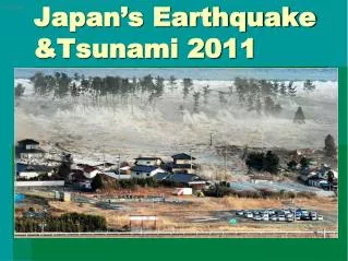
(REUTERS). Japan’s Earthquake &Tsunami 2011. Magnitude 9.0 NEAR THE EAST COAST OF HONSHU, JAPAN Friday, March 11, 2011 at 05:46:23 UTC. Images courtesy of the US Geological Survey. The earthquake occurred 130 km (80 miles) east of Sendai and 373 km (231 miles) northeast of Tokyo.

Japan’s Earthquake &Tsunami 2011
E N D
Presentation Transcript
(REUTERS) Japan’s Earthquake &Tsunami 2011
Magnitude 9.0 NEAR THE EAST COAST OF HONSHU, JAPANFriday, March 11, 2011 at 05:46:23 UTC Images courtesy of the US Geological Survey
The earthquake occurred 130 km (80 miles) east of Sendai and 373 km (231 miles) northeast of Tokyo.
This is one of the largest earthquakes that Japan has ever experienced. In downtown Tokyo, large buildings shook violently. Elsewhere severe flooding occurred due to a tsunami generated by the earthquake. Part of houses swallowed by tsunami burn in Sendai, Miyagi Prefecture (state) after Japan was struck by a strong earthquake off its northeastern coast Friday, March 11, 2011. New York Times
The earthquake caused some damage – but the tsunami was devastating Tsunami waves swept away houses and cars in northern Japan and pushed ships aground. The tsunami waves traveled far inland, the wave of debris racing across the farmland, carrying boats and houses with it.
Fires after earthquakes are often caused by broken gas pipelines CNN reported “The quake rattled buildings and toppled cars off bridges and into waters underneath. Waves of debris flowed like lava across farmland, pushing boats, houses and trailers toward highways.” A number of fires broke out including one at an oil refinery which was burning out of control. Giant fireballs rise from a burning oil refinery in Ichihara, Chiba Prefecture (state) after Japan was struck by a strong earthquake off its northeastern coast Friday, March 11, 2011. Los Angeles Times
Let’s take a look at tsunami as it hits the east coast of Japan http://www.bbc.co.uk/news/world-asia-pacific-12725646
Globally, this is the 5th largest earthquake since 1900 (or 4th depends on M). Chile 1960 Alaska 1964 Sumatra 2004 Russia 1952 Japan 2011 Ecuador 1906 Chile 2010 Alaska 1965
What is a Tsunami? (harbor wave) Seismic sea waves (NOT tidal waves) Large ocean wave or series of ocean waves generated by an earthquake, volcanic eruption, submarine landslide or meteor impact
How do EQs cause a tsunami? http://sese.asu.edu/teacher-resources http://geology.com/articles/tsunami-geology.shtml
Tsunami causes • Unless there is an underwater landslide, strike-slip EQ WILL NOT cause tsunami • Most tsunami generated by subduction zones • Chile • Alaska • Japan • Cascadia • Philippines • Caribbean • New Zealand
Tsunami wavelength and speed • Long wavelengths (over 100 km) • Travel at high speeds : 450 to 650 mph 316,800 ft = 60 miles
Projected travel times for the arrival of tsunami waves across the Pacific Nearby the earthquake there are only minutes to evacuate. However, in many other regions there is advance warning. How long before the tsunami reaches Los Angeles?
What happens when tsunami gets near shore? • Tsunami slows down (shallower water) • Wave gets taller
Tsunami nears shore • As wave gets into shallow water bottom of wave drags along ocean floor • Top of wave still moving fast: causes cresting of wave, and breaking onto shore
Tsunami warning Receding of coastal waters ( 5 - 15 minutes before the strike ).
Approaching tsunamis are almost always heralded by a noticeable fall of coastal waters. Water may recede several hundreds of meters. If you are on the beach, and you see water suddenly receding, exposing the ocean floor, it means that you have minutes before the tsunami strikes. What do you do?
Let’s take a look at what Japan looks like before and after http://www.abc.net.au/news/specials/japan-quake-2011/
Detecting a tsunami • Pressure recorder on bottom of ocean • Buoy to communicate readings via satellite • Tsunami Warning Centers issue warning
Tsunami Warning Centers • Hawaii and Alaska • When EQ considered capable of generating tsunami, send warning with estimated arrival time • Once tsunami hits somewhere, tsunami watch established to monitor tide gauges and ocean buoys
Tsunami Monitoring Systems Locations of NOAA’s National Data Buoy Center (NDBC) DART stations comprising the operational network.
Tsunami Warning • When warning is issued – low lying areas are evacuated • U.S. Coast guard issues warnings over marine frequencies • Some places have sirens