Download
1 / 7
70 likes | 183 Vues
Explore spatial aggregation using field methods in Boulder County Parks and Open Space. Analyze changes in canopy cover, openings, total cover, and opening size. Evaluate treatment effects and scale considerations for operational use. Consider trade-offs in monitoring resources for landscape analysis.

E N D
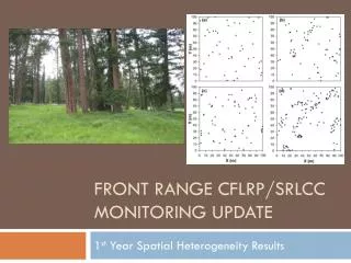
Front Range CFLRP/SRLCC Monitoring Update 1st Year Spatial Heterogeneity Results
Field Methods • Spatial Aggregation “Groupy-Clumpy” Transect • Was not limited to NFS lands • Boulder County Parks and Open Space • Oriented from Plot Center true north on all SRLCC CSE Plots • 100 meter transect, measuring number and distance of Single story/multistory canopy cover and openings Single Story Multi Story Openings
Take home • Total openings increased from pre to post treatments conditions • Though differences were variable when compared to control sites • Mean single opening size increased • Again the variation between pre, post, and the controls were observed. • Future use? • Ground truth remote sensing products and analyses • Operational use for TSA, and/or contractors
Treatment effects scale considerations • Limited monitoring resources, to evaluate a vast resource (Landscape) at fine scales (within stand/patch) • We have to make decisions as to what level of confidence we have in the data and what appropriate inferences we can be drawn from that data. • Trade-offs • A very good understanding (i.e. beyond a reasonable doubt”) at small scales in a limited number of site, vs • A pretty good understanding (i.e. “a preponderance of evidence”) at larger scales with more sites.