Download
1 / 16
160 likes | 269 Vues
How to do a Cost-Benefit Analysis in ELD: a case study from the Ethiopian Highlands. Hans Hurni University of Bern. ELD Ethiopia Project Scope: Soil degradation and sustainable land management in rain-fed agriculture Location: Ethiopian Highlands

E N D
How to do a Cost-Benefit Analysis in ELD: a case study from the Ethiopian Highlands Hans Hurni University of Bern
ELD Ethiopia Project Scope: Soil degradation and sustainable land management in rain-fed agriculture Location: Ethiopian Highlands Spatial scale: Multi-scale from local to national Strategic focus: Provide a spatially explicit model for cost-benefit analysis (CBA) of sustainable land management (SLM). Define further inputs for modelling the total economic value (TEV) of the Ethiopian Highlands. Inform decision-makers about best options for sustainable water and land management in Ethiopia.
Definition of Total Economic Value (TEV): • “The full economic value allocated by society as a whole. This includes use value (direct and indirect, option value) and non-use value.” • ELD Initiative 2013 • Case study Ethiopian Highlands: • direct use value through agricultural (crop and livestock) production • indirect use value through water (and sediment) delivery for lowland irrigation • option value for ecotourism and biodiversity (e.g. wildlife) conservation • non-use value through water (and sediment) delivery for lowland irrigation
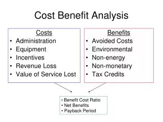
Cost-benefit analysis: • “A comparison of all of the costs and benefits associated with taking action, compared • to ‘business-as-usual’ (changing nothing). ” • ELD Initiative 2013 • ELD Ethiopia Project 2014 • Spatially explicit case study of the direct agricultural use value of land in the Ethiopian Highlands: • Costs and benefits of past and actual (SWC) action • Costs and benefits of optimum (SLM) action • Costs and benefits of ‘business-as-usual’ (inaction)
Recalling the 6+1 steps to estimate the economic benefits and costs of action 1. Inception: Identification of the scope, location, spatial scale, and strategic focus of the study 2. Geographical characteristics: Assessment of quantity, spatial distribution, and ecological characteristics 3. Types of ecosystem services: Analysis of ecosystem services stocks and flows 4. Role of ecosystem services in community livelihoods and economic valuation: Role of the assessed ecosystem services in the livelihoods of the communities; role of overall economic development 5. Land degradation patterns and pressure: Identification of land degradation patterns, drivers and pressure on the sustainable management of land resources 6. Cost-benefit analysis and decision-making: Assessment of sustainable land management options +1 step: Take action!UNCCD; in ELD Methodology 2013
Changes in cultivated biomass and grain yield in an Ethiopian catchment (110 ha) conserved in 1983 Biomass Grain Source: Mirka Loetscher 2003, based on SCRP data
ELD Ethiopia Project Approach (2014) Component 1:Land cover classification - Land cover map at the national level - Classification approach using GIS and Remote Sensing Component 2:Detection of physical SLM structures - Data availability (high resolution Google Earth) - Automated mapping of SLM structures (remote sensing) Component 3:Assessment of soil erosion and the relationship to crop yield - RUSLE model and calibration data from field experiments - Soil erosion assessment beyond RUSLE - Relating soil erosion to soil depth and crop yield Component 4:Evaluating the costs of soil degradation and the economics of SLM practices - Implementation steps of economic valuation - Spatial valuation of SLM measures - Discussion of livelihood options
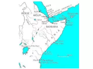
Country Report CRA Watershed Management EthiopiaMap 47, p. 168
0 m 600 m Comparison of Landsat classi- fication(left) with high resolution Google Earth image (below left); automated mapping and quality assessment of SWC structures in Anjeni, Ethiopia (below).
Cropyield Soildepth Crop yield (quintal/ha) versus soil depth (cm) relationship for a crop basket in the moist WeynaDega agroecological zone with Fanya juu soil conservation structures (example no. 23, ELD Ethiopia model)