Environmental Impact of Gypsum Spill in Grand Bay, MS: Effects on Estuaries and Ecosystems
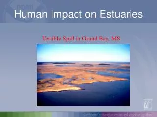
A recent spill from a gypsum stack near a fertilizer company has severely impacted the Grand Bay estuary in Mississippi. The spill contaminated the nearby Bangs Lake, leading to algae blooms observable on the lake's surface. Photographs captured by the Grand Bay National Estuarine Research Reserve reveal the extensive damage to marsh grass and water quality in the affected area. The spill crossed a road and raised concerns about the ecological health of the region, highlighting the importance of monitoring water quality in estuarine environments.

Environmental Impact of Gypsum Spill in Grand Bay, MS: Effects on Estuaries and Ecosystems
E N D
Presentation Transcript
Human Impact on Estuaries Terrible Spill in Grand Bay, MS
Gypsum stack around a retaining pond holding wastewater (Image: Grand Bay National Estuarine Research Reserve)
Fertilizer company is in the upper left corner. The spill crossed the road in the middle of the image and entered the lake. The faint green in the lower right corner are algal mats on the surface.Photo: Grand Bay NERR
Area where the spill entered Bangs Lake. Note the algal mats on the left side of the image. Photo: Grand Bay NERR
Algal mats growing on the surface of the lake amid damaged marsh grass.Photo: Grand Bay NERR
The fertilizer factory can be seen in the lower right corner. The red marker in the middle of the image shows the area of the lake where the spill entered. The other red marker shows the closest water quality monitoring station to the spill.Photo: Grand Bay NERR